Cochran Creek Falls to Amicalola Falls
|
|
The Basics: |
| Event Type: |  | Hike | |
|
Event Location: | |
Chattahoochee National Forest, near Dawsonville, GA


| |
| Date(s) & Time: | | Sat, Dec 17 2011
9:30 am >> Sat, Dec 17 2011 6:00 pm (Carpool Departure: 8:30 pm *log in for location*)
| |
| Registration Opens:
| |
Fri, Dec 16 2011 3:00 pm
| |
| Registration Cut Off:
| |
Fri, Dec 16 2011 8:00 pm
| |
| Event Duration: | | Per Itinerary | |
| Difficulty Rating: | | D5: Difficult (Exploratory) | |
| Distance: | | 9.5 Miles | |
| Pace: | | Moderate | |
Trip Leader(s):
| | Tony C
Charlie Cottingham
 Email Trip Leader(s) Email Trip Leader(s)
You must be logged in to get the Trip Leader contact information.
| |
| Member Cost: | | None |
|
| Participant Info: |
| Who's Invited: | |
Members Only, 21 And Older Only
| |
| Maximum Group Size: | | 10 |
| Minimum Group Size: | | 5 |
| Number Registered So Far: | |
5 / 0 (To see who's signed up, log in to the Member Area)
|
| Are Dogs Permitted: | |
Yes
|
|
Note: This is an "EXPLORATORY" trip. This means that there are parts of this trip, or perhaps the whole trip, that is new to your Trip Leader(s). However, they are confident that this will not be an issue.
This note is here so that you can make an informed decision. When a Trip Leader isn't personally familiar with a trip, there is an increased chance of things not going as planned and you need to be prepared. The Trip Leader may have additional details in the itinerary.
|
| Itinerary: |
Ok our original plan for today was the Tray Mtn D6 explorer hike but due to forecast rain on Friday, we rescheduled that one because six miles of bushwhacking would not be fun on wet terrain...also not as as safe as dry conditions.
So instead going to do a hike that is new to the AOC...Cochran Falls to Amicalola Falls. This should be a good one and we have to thank fellow Trip Leaders Bobby, and Ron for helping us to scout it out and figure it out. They will hopefully be leading this same hike or something similar in the next few months, so if you can't make this one, look for more hikes to this special spot soon.
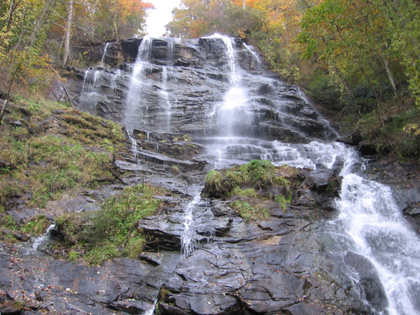
Cochran Falls is a lesser known GA waterfall, but not due to any lack of beauty. It is very unique and impressive but just involves some rugged, challenging terrain to reach it, which is mainly why this is categorized as a D5. We may have to be creative in our route and definitely will take careful steps but I've done the first part of this hike three times now, and am fairly comfortable with it.
The wet conditions from the rain won't help but it should make the falls more voluminous, and if we do get to where don't feel comfortable, we can always fall back and just go to Amicalola for a long hike on the AT Approach Trail. Bearden Falls is nearby too and could check that one out as well.
But we hope to keep to our plan, which is to drop a shuttle vehicle off at Amicalola State Park and then drive just about 7 miles to the Cochran Falls trailhead...well not really a trailhead but just will park along the side of a forest service road and walk from there. We start out on some logging roads and then head up into the woods, then skirt the creek a few times and climb around some rocks. We then start to gain elevation in earnest and end up at the base of Cochran Creek Falls. I would post a pic but don't want to ruin any surprises.
After a long break there, we will climb up a short section near the falls. This is maybe class 3 rock scrambling for about 6 feet and then just some climbing up a steep grade but some trees to hold onto and shouldn't be too bad. It was very manageable in dry conditions.
We work our way on an unofficial trail to the top of the falls where we will enjoy a beautiful view to the south. Then it's about half a mile headed NW on another unofficial use trail until we reach the Len Foote Hike Inn trail. From there, it will be fairly straightforward hike to the Inn and then NW to the AT Approach Trail, where we will hang a left and then head back to Amicalola Falls State Park. We will check out the falls here and then walk down to our shuttle vehicle. The drivers will go retrieve the other vehicles at Cochran TH and then back home.
The total distance should be about 9 1/2-10 miles and 2500' of total ascent.
NOTE: This is a D5 event, so if you haven't done anything similar with the AOC in the past, the Trip Leaders will be contacting you to determine if this is the right hike for you. You should be comfortable doing some light scrambling on this one and expect some rugged, slightly challenging terrain on the first part of the route. |
|
Required Items to Bring:
water and food
hiking shoes or boots
| | Recommended Items to Bring:
Use our Event Checklists to make sure you have everything you need.
trekking poles
camera | |
|
| How to Get There: |
| Event Directions: | | Directions will be given at carpool or email if Meet at Event. | |
| Carpool to Event Distance (round trip): | | 112Mile(s) |
| Carpool Departure Time: | |
8:30 pm
|
| Carpool Location: | |
Log in for location
|
| Carpool Directions: | |
Log in for directions
|
| Carpool Cost: | |
Estimated cost per vehicle for this event is $44.80 using a reimbursement rate guideline of $0.400 per mile. The total amount should be divided by the number of people in the vehicle, including the driver. This is a guideline, not a rule, for drivers but the cost should not be higher unless there are extenuating circumstances.
|
|
| Notes: |
|
|
|
| Cost Includes: | | NA |
Cancellation/Partial Attendance: Please review the AOC cancellation policy. |
 Print-Friendly Version
 Calendar of Events
 Event Places