 Print-Friendly Version Print-Friendly Version
|
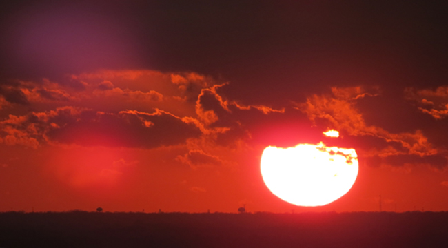
Summit Sunset Series #8 - Sweat Mountain | |||||||
| The Basics: | |||||||
| Event Type: | Hike | ||||||
| Event Location: |
Marietta, GA


| ||||||
| Date(s) & Time: | Wed, Jan 25 2012 5:00 pm >> Wed, Jan 25 2012 6:15 pm (Carpool Departure: 4:45 pm *log in for location*) | ||||||
| Registration Opens: | Tue, Jan 24 2012 8:30 pm | ||||||
| Registration Cut Off: | Wed, Jan 25 2012 5:00 pm | ||||||
| Event Duration: | 1 Hours 15 Minutes | ||||||
| Difficulty Rating: | D2: Easy to Moderate | ||||||
| Distance: | 1 Miles | ||||||
| Pace: | Moderate | ||||||
| Trip Leader(s): | Tony C Joyce T.  Email Trip Leader(s) Email Trip Leader(s)
You must be logged in to get the Trip Leader contact information. | ||||||
| Member Cost: | None | ||||||
| Participant Info: | |||||||
| Who's Invited: | Members Only, 21 And Older Only | ||||||
| Maximum Group Size: | 10 | ||||||
| Minimum Group Size: | 4 | ||||||
| Number Registered So Far: | 4 / 0 (To see who's signed up, log in to the Member Area) | ||||||
| Are Dogs Permitted: | No | ||||||
| Itinerary: | |||||||
Ok very short notice on this but weather hsa been questionable all day...going to give it a shot though... Sweat Mountain is also a part of the ridge that divides the Chattahoochee River basin to the south and southeast, from the Lake Allatoona (Etowah River) basin to the north and northwest. From Sweat Mountain, this runs west-southwest through Cobb to Kennesaw Mountain and Lost Mountain (thanks wikipedia) This isn't a very well-known sunset spot, but it's a good one. After about a tenth of a mile of off trail hiking through some woods, there is a trail with blazes going up to a west facing overlook, about 80 feet below the summit. But it's only about a half mile up and back down so a 1 mile hike total....however you do gain 450', so it is fairly steep and you should be in solid D2 shape for this hike and not a total beginner. Because of limited parking, we will carpool to the trailhead from a nearby shopping center and just take a max of two vehicles. There is no "Meet at Event" but essentially you are doing the same thing by meeting at the carpool, just 3 miles away. Bring a headlamp or flashlight..if we do get a good sunset, we won't rush down afterwards and will stay to watch the afterglow and then probably will be fairly dark at that point. If it is cloudy and we don't get our sunset, we won't need the lights. | |||||||
| |||||||
| How to Get There: | |||||||
| Event Directions: | No Meet at Event...carpool only..see details below.. | ||||||
| Carpool to Event Distance (round trip): | 6Mile(s) | ||||||
| Carpool Departure Time: | 4:45 pm | ||||||
| Carpool Location: | Log in for location | ||||||
| Carpool Directions: | Log in for directions | ||||||
| Carpool Cost: | Estimated cost per vehicle for this event is $2.40 using a reimbursement rate guideline of $0.400 per mile. The total amount should be divided by the number of people in the vehicle, including the driver. This is a guideline, not a rule, for drivers but the cost should not be higher unless there are extenuating circumstances. | ||||||
| Notes: | |||||||
|
* We encourage all members to follow our Etiquette Guidelines while participating in AOC events. | |||||||
| Cost Includes: | NA | ||||||
Cancellation/Partial Attendance: Please review the AOC cancellation policy. *Note: NA | |||||||
 Calendar of Events
 Event Places