 Print-Friendly Version Print-Friendly Version
|
|
Coosa Backcountry Loop | |||||||
| The Basics: | |||||||
| Event Type: | Hike | ||||||
| Event Location: |
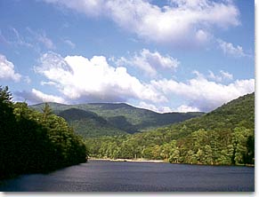
Vogel State Park


| ||||||
| Date(s) & Time: | Sun, Feb 5 2012 9:00 am >> Sun, Feb 5 2012 6:00 pm (Carpool Departure: 7:30 am *log in for location*) | ||||||
| Registration Opens: | Tue, Jan 24 2012 8:00 pm | ||||||
| Registration Cut Off: | Fri, Feb 3 2012 5:00 pm | ||||||
| Event Duration: | 9 Hours | ||||||
| Difficulty Rating: | D5: Difficult | ||||||
| Distance: | 12.9 Miles | ||||||
| Pace: | Moderate | ||||||
| Trip Leader(s): | Scott Laura  Email Trip Leader(s) Email Trip Leader(s)
You must be logged in to get the Trip Leader contact information. | ||||||
| Member Cost: | None | ||||||
| Participant Info: | |||||||
| Who's Invited: | Members Only, 21 And Older Only | ||||||
| Maximum Group Size: | 12 | ||||||
| Minimum Group Size: | 3 | ||||||
| Number Registered So Far: | 12 / 0 (To see who's signed up, log in to the Member Area) | ||||||
| Are Dogs Permitted: | Yes | ||||||
| Itinerary: | |||||||
| The Coosa Backcountry Loop is a long and strenuous trek, especially as a day hike. It leaves Vogel State Park and climbs to Burnett Gap. From here, the trail circles the Sosebee Creek valley, where it reaches a low point. From Sosebee Creek, the path makes a long climb to wooded Coosa Bald, breaking the 4,000-foot elevation mark. Some serious ups and downs follow as the path enters the Blood Mountain Wilderness and reaches Slaughter Mountain before making its way back down to the state park. We will climb and descend over 1 mile in elevation crossing 3 ridgelines at a moderate pace with plenty of stops for photos and lunch. This is NOT a beginners hike, so please be sure you are in good physical condition. However, we will not be hiking at a fast or fitness hike pace. (Trail Description from 50 Hikes In the North Georgia Mountains by Johnny Molloy) | |||||||
| |||||||
| How to Get There: | |||||||
| Event Directions: | Vogel State Park GPS Coordinates: Located 11 miles south of Blairsville via U.S. Hwy. 19/129.
| ||||||
| Carpool to Event Distance (round trip): | 134Mile(s) | ||||||
| Carpool Departure Time: | 7:30 am | ||||||
| Carpool Location: | Log in for location | ||||||
| Carpool Directions: | Log in for directions | ||||||
| Carpool Cost: | Estimated cost per vehicle for this event is $53.60 using a reimbursement rate guideline of $0.400 per mile. The total amount should be divided by the number of people in the vehicle, including the driver. This is a guideline, not a rule, for drivers but the cost should not be higher unless there are extenuating circumstances. | ||||||
| Notes: | |||||||
|
Trail Map: http://gastateparks.org/content/Georgia/parks/trail_maps/Vogel2010-trailmap.pdf * We encourage all members to follow our Etiquette Guidelines while participating in AOC events. | |||||||
| Cost Includes: | Free, but there is a $5.00 parking fee per car, if you do not already have a Georgia State Park parking pass. | ||||||
Cancellation/Partial Attendance: Please review the AOC cancellation policy. *Note: Will This Event Occur Rain or Shine? No. | |||||||
 Calendar of Events
 Event Places