 Print-Friendly Version Print-Friendly Version
|
|
Blood Mountain Loop via Lake Winfield Scott | |||||||
| The Basics: | |||||||
| Event Type: | Hike | ||||||
| Event Location: |
Near Suches Georgia


| ||||||
| Date(s) & Time: | Sat, Jan 28 2012 9:45 am >> Sat, Jan 28 2012 3:45 pm (Carpool Departure: 8:00 am *log in for location*) | ||||||
| Registration Opens: | Wed, Jan 25 2012 6:32 pm | ||||||
| Registration Cut Off: | Fri, Jan 27 2012 11:59 pm | ||||||
| Event Duration: | 6 hours plus 3.25 hours drive time | ||||||
| Difficulty Rating: | D4: Moderate to Difficult | ||||||
| Distance: | 11 Miles | ||||||
| Pace: | Moderate | ||||||
| Trip Leader(s): | John Weatherman Email Trip Leader(s) Email Trip Leader(s)
You must be logged in to get the Trip Leader contact information. | ||||||
| Member Cost: | None | ||||||
| Participant Info: | |||||||
| Who's Invited: | Members Only, 21 And Older Only | ||||||
| Maximum Group Size: | 16 | ||||||
| Minimum Group Size: | 4 | ||||||
| Number Registered So Far: | 8 / 0 (To see who's signed up, log in to the Member Area) | ||||||
| Are Dogs Permitted: | Yes | ||||||
| Itinerary: | |||||||
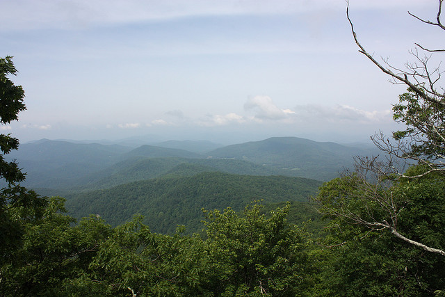
| Blood Mountain is almost 4,500 feet high and is the highest point on the AT in Georgia. Saturday is expected to be clear, so it is possible we will be able to see downtown from the top where we will have our lunch. In any case, we will have good views in all directions. From Lake Winfied Scott we will hike up the Jarrad Gap Trail (1.2 miles) then go left on the AT (2.2 miles), to right on the Freeman Trail (1.8 miles), then up Blood Mtn on the AT (1 mile), lunch at the summit, then down on the AT to Slaughter Gap (1.7 miles), and take the Slaughter Gap trail (2.7 miles) back to the start. Total of about 11 miles. About half of this hike will be along the Appalachian Trail, and there will be numerous overlooks on the way up. This is a hard hike, so do not sign up if you have never been on a D4 hike. That said, it is not a fast hike, so if you want to charge ahead, please sign up for something else. There are several turns and we will need to stop and wait for people at these turns. If you do not want to wait, please do not sign up. | |||||||
| |||||||
| How to Get There: | |||||||
| Event Directions: | 1. North on GA 400 2. When 400 ends Turn left at traffic light onto US 19 3. In Dahlonega take US 19 bypass 4. Continue on US 19 until you reach GA 60 and take left. 5. On GA 60 you will climb for about 7 miles. 6. In Suches take right onto GA 180. 7. Proceed east until you reach Lake Winfield Scott in about 5 miles. 8. Pay parking fee near entrance. Use parking lot near lake. | ||||||
| Carpool to Event Distance (round trip): | 135Mile(s) | ||||||
| Carpool Departure Time: | 8:00 am | ||||||
| Carpool Location: | Log in for location | ||||||
| Carpool Directions: | Log in for directions | ||||||
| Carpool Cost: | Estimated cost per vehicle for this event is $54.00 using a reimbursement rate guideline of $0.400 per mile. The total amount should be divided by the number of people in the vehicle, including the driver. This is a guideline, not a rule, for drivers but the cost should not be higher unless there are extenuating circumstances. | ||||||
| Notes: | |||||||
|
* We encourage all members to follow our Etiquette Guidelines while participating in AOC events. | |||||||
Cancellation/Partial Attendance: Please review the AOC cancellation policy. | |||||||
 Calendar of Events
 Event Places