Map & Compass Hike and O Meet at East Palisades. Event still ON!
|
|
The Basics: |
| Event Type: |  | Learn | |
|
Event Location: | |
NW Atlanta by the Chattahoochee River


| |
| Date(s) & Time: | | Sun, Feb 19 2012
9:30 am >> Sun, Feb 19 2012 1:00 pm
| |
| Registration Opens:
| |
Mon, Feb 6 2012 9:30 pm
| |
| Registration Cut Off:
| |
Sat, Feb 18 2012 6:00 pm
| |
| Event Duration: | | 3 Hours 30 Minutes | |
| Difficulty Rating: | | D2: Easy to Moderate | |
| Distance: | | 4 Miles | |
| Pace: | | Leisurely | |
Trip Leader(s):
| | Charlie Cottingham
Kathy Malone
 Email Trip Leader(s) Email Trip Leader(s)
You must be logged in to get the Trip Leader contact information.
| |
| Member Cost: | | None |
|
| Participant Info: |
| Who's Invited: | |
Members Only, 21 And Older Only
| |
| Maximum Group Size: | | 15 |
| Minimum Group Size: | | 4 |
| Number Registered So Far: | |
9 / 0 (To see who's signed up, log in to the Member Area)
|
| Are Dogs Permitted: | |
No
|
|
| Itinerary: |
WEATHER UPDATE as of SAT EVENING FEB 18: We're still ON for the event, but the latest weather report shows the front moving through Atlanta slower than had been expected, so now we may have a quarter of an inch or so of rain after the O Meet begins. I'll put up a large tarp that will keep us dry during our Map & Compass "Tutorial" session. It's still expected to be in the low 50s with an occasional light drizzle or shower Thankfully there won't be much wind until midafternoon.. Please prepare and dress accordingly. By the way, if you choose to cancel, no problem - we'll be offering a similar AOC "O" participation event and Map/Compass tutorial again in the near future! -Charlie
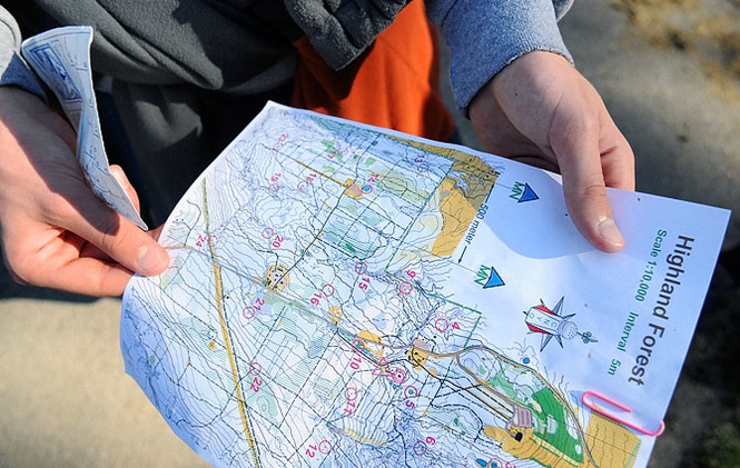
IN A NUTSHELL: Known for its excellent network of hiking trails and high rocky cliffs that tower above the river, the East Palisades unit of the Chattahoochee River National Recreation Area (CRNRA) is conveniently located near the I-285/ I-75 Interchange in NW Atlanta. This AOC hiking adventure and map & compass learning experience will be held in conjunction with the Feb 19 "O Meet" hosted there by Charlie's friends in the GA Orienteering Club.
Our AOC "subgroup" will gather at 9:30 AM in the upper parking lot (see detailed directions below). Several dozen other participants from the O Club and the public at large will arrive a bit later.
The event will be fun for hikers of all experience levels and great way to learn and practice map & compass skills. Our "wayfaring O hike" will be at an easy to moderate pace and likely no more than 4 miles in length, along the scenic wooded trails adjoining the river, and occasionally a bit off-trail through parts of the forest.
EVENT PLAN: After introductions we'll conduct a half-hour "refresher tutorial" for our AOC subgroup in the basics of how to use a compass in conjunction with a topographic map and how to find our way confidently through unfamiliar terrain. We'll also discuss the basics of the sport of Orienteering and sign up to take part in the O Meet as a "wayfaring group" —see more below.
We AOCers will then set off together on the “Yellow” O course, suitable for both experienced and beginner "O hikers". Along the way we'll practice our map & compass skills to locate about ten partially hidden “control flags” whose locations are shown on our topo map. After reaching each flag we’ll take a close look at our map and "clue sheet" and discuss appropriate “attack strategies” for finding the next flag in the course’s sequence.
We’ll share several copies of the GAOC's East Palisades topographic map which we'll specially mark for the Yellow course. Bring your own compass if you have one – otherwise feel free to borrow one of our “loaner” compasses. We plan to take a relaxed “wayfaring” pace, although many O Meet competitors that day will be trying for max. speed between control flags.
Our group O hike on the Yellow course is expected to last about 2 hours after which you're welcome to try part of a more advanced course on your own if you like. The control flags will be picked up by O Club volunteers beginning at about 3:00 PM so it's important to check in back at the Start by then.
OPTIONAL POST-HIKE GROUP LUNCH (about 1:00 PM): After the event feel free to join Charlie for lunch at a nearby restaurant - separate checks. We can agree upon an appropriate spot at the meet and quickly caravan to it in our vehicles.
WHAT IS ORIENTEERING? It’s a sport that blends the fun of a scavenger hunt with the adventure of navigating between flagged checkpoints in unfamiliar natural terrain. We “orienteer” using a detailed topographic map, a simple compass, and our judgment as to which route to take between partially hidden white & orange control flags whose positions and surrounding land & water features are shown on the map. Before tackling an O course we’re also usually given a "clue sheet" that describes the main topographic features in the immediate vicinity where each flag is hung.
We’re fortunate to have in Atlanta a very active and friendly not-for-profit “O” club. GA Orienteering Club volunteers organize year-round “O Meets” and “O” education programs at parks and wilderness preserves throughout north Georgia. The general public is welcomed at GAOC events without formal membership. GAOC dues are only $8 per year (or $12 per couple, $15 per family) and members get discounted maps at O meets. The map & registration fee at most meets, even for non-members, is only about $8.00.
More Info on GA Orienteering Club: www.GAOrienteering.org
Great webpage on Compasses and how to use your compass with a map:
http://web.williams.edu/Biology/Faculty_Staff/hwilliams/Orienteering/compass.html
GAOC Online Tutorial on the basics of Orienteering:
http://gaorienteering.org/Education/BeginnerGuide/introduction.htm
More on Chattahoochee River National Rec Area: http://www.nps.gov/chat/ |
|
Required Items to Bring:
• Comfortable broken-in Athletic Shoes or Hiking Boots with wool-blend or synthetic Socks. Avoid 100% cotton.
• Lightweight comfortable Clothing layers appropriate for the weather. Long Pants are suggested, since we’ll be occasionally walking off-trail through the forest.
• Compass if you have one. A simple "protractor-type" compass on a clear plastic rectangular base is fine. They're available for about $10 or less at Wal-Mart, Sports Authority, REI, etc. We'll have several "loaner" compasses on hand for you to share if it's inconvenient for you to bring one.
• Water: About 1 liter, in “Camelbak-style” hydration system or bottles in a small daypack/fanny pack.
• $3 in Cash for the CRNRA self-serve Parking Fee envelope if you drive and don't display an annual Nat'l Parks parking pass.
| | Recommended Items to Bring:
Use our Event Checklists to make sure you have everything you need.
• Consider carrying a light Daypack or Fanny Pack for stashing unneeded layers as you warm up and for your water bottle, camera, snack, emergency rain gear, etc.
• Optional: Trekking Pole(s) or Hiking Stick.
• Optional: Your Camera!
• Several copies of the E Palisades O Map will be provided for our group to share at no charge by your Trip Leaders. If you'd like your own personal copy to use and to keep for future use, bring $3 in cash to cover this additional expense. When we register for the meet as a "wayfaring group" we can buy extra maps at this discounted price."
| |
|
| How to Get There: |
| Event Directions: | |
DIRECTIONS to CRNRA EAST PALISADES UPPER PARKING LOT (a.k.a. the "Indian Trail" lot). It's in NW Atlanta about 5 minutes south of I-285 Exit #22, via the approach options below. Don't forget to take care of your self-serve $3-per-car parking fee if you don't display a valid pass. (Caution! This is NOT the free I-85 MARTA lot at the "Indian Trail Road" exit where AOCers often meet for carpooling !)
OPTION A: FROM the I-285/ I-75 INTERCHANGE in NW ATLANTA:
1. Take I-285 eastward about 1 mile and get off at your first opportunity, Exit #22, "Northside Drive/ New Northside Drive/ Powers Ferry Road."
2. At the end of the ramp turn Right onto Northside Drive and go 1.1 mile to Indian Trail on your right. (En route pass through the traffic light at Powers Ferry Rd.)
3. Turn Right onto Indian Trail and go about 0.4 mile. (Indian Trail becomes gravel and ends at the CRNRA parking lot.).
OPTION B: FROM the I-285/ GA-400 INTERCHANGE in NORTH ATLANTA:
1. Take I-285 westward about 4 miles and get off at Exit #22, "New Northside Drive/ Northside Drive/ Powers Ferry Road."
2. At the end of the ramp continue straight ahead about 0.2 mile (on the I-285 access road) to the next traffic light at Northside Drive.
3. Turn Left onto Northside Drive and go 1.3 mile to Indian Trail on your right. (En route pass through the traffic light at Powers Ferry Rd.)
4. Turn Right onto Indian Trail and go about 0.4 mile. (Indian Trail becomes gravel and ends at the CRNRA parking lot.)
STREET ADDRESS and LAT/LON COORDINATES of E Palisades upper Parking Lot are given below. You may wish to enter this "dummy" address or lat/lon as your destination for GPS navigation or Google Maps in conjunction with the above directions:
1490 Indian Trail NW, Sandy Springs, GA 30327
33.8880,-84.4336
| |
|
| Notes: |
|
|
|
| Cost Includes: | | Like other Chattahoochee River Nat'l Recreation Area units, this East Palisades upper parking lot has a $3 per vehicle parking fee. Unless you display a valid U. S. National Parks annual parking pass it's your responsibility to take care of this with a self-serve envelope and to hang the tear-off receipt on your rear-view mirror. Otherwise this is a Free Event with several shared Maps and our O Meet group Registration covered by your AOC event leaders. |
Cancellation/Partial Attendance: Please review the AOC cancellation policy. |
 Print-Friendly Version
 Calendar of Events
 Event Places