 Print-Friendly Version Print-Friendly Version
|
Scaly Mountain Hike NC - Great Views, Clear Skies Forecast | |||||
| The Basics: | |||||
| Event Type: | Hike | ||||
| Event Location: | Scaly Mountain � Bartram Trail | ||||
| Date(s) & Time: | Sat, Feb 25 2012 10:15 am >> Sat, Feb 25 2012 3:30 pm (Carpool Departure: 8:15 am *log in for location*) | ||||
| Registration Opens: | Mon, Feb 20 2012 9:57 pm | ||||
| Registration Cut Off: | Fri, Feb 24 2012 9:00 pm | ||||
| Event Duration: | 5 Hours 15 Minutes | ||||
| Difficulty Rating: | D4: Moderate to Difficult | ||||
| Distance: | 7.5 Miles | ||||
| Pace: | Moderate | ||||
| Trip Leader(s): | Steven K Michelle Spence  Email Trip Leader(s) Email Trip Leader(s)
You must be logged in to get the Trip Leader contact information. | ||||
| Member Cost: | None | ||||
| Participant Info: | |||||
| Who's Invited: | Members Only, 21 And Older Only | ||||
| Maximum Group Size: | 16 | ||||
| Minimum Group Size: | 6 | ||||
| Number Registered So Far: | 9 / 0 (To see who's signed up, log in to the Member Area) | ||||
| Are Dogs Permitted: | No | ||||
| Itinerary: | |||||
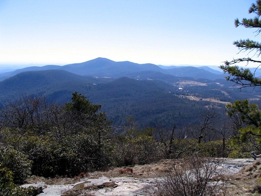
This is really two separate hikes. The first three and half miles will be south of the Osage Overlook. We will follow the Bartram Trail and two side trails: Hurrah Ridge and West Fork to form a loop. The area is heavily forested and has many stream crossings. Fortunately most crossings have bridges so unless there are heavy rains the week before; you should not get too wet. Do expect to get a little muddy. After returning to the Osage Overlook, we will go north on the Bartram Trail for the second part of our hike. Here we will ascend over 1000 feet in two miles to reach the summit of Scaly Mountain at 4804 feet. To gain this much elevation in that short of a distance there will be some steep sections. Depending on weather conditions it could be slippery or icy. However when you make it to the top you will be rewarded with great views of the valley below. There are several rocky out-croppings similar to Blood Mountain and if the weather is nice I am sure we will want to stay a while. This is not a bad hike for hike for beginning hikers, but still I would not recommend it unless you are in pretty good shape. It is great having newcomers on hikes, but if you have any questions whether this is the right hike for you, please e-mail the hike leader. | |||||
| |||||
| How to Get There: | |||||
| Event Directions: | North on I-85. Take I-985 split to Gainesville. After 26 miles name will change to US 23. Continue on US 23 through Clayton GA. Past Dillard GA take right on GA 246. When it crossing into NC, the highway name changed to NC 106. Continue to Osage Overlook parking lot. | ||||
| Carpool to Event Distance (round trip): | 210Mile(s) | ||||
| Carpool Departure Time: | 8:15 am | ||||
| Carpool Location: | Log in for location | ||||
| Carpool Directions: | Log in for directions | ||||
| Carpool Cost: | Estimated cost per vehicle for this event is $84.00 using a reimbursement rate guideline of $0.400 per mile. The total amount should be divided by the number of people in the vehicle, including the driver. This is a guideline, not a rule, for drivers but the cost should not be higher unless there are extenuating circumstances. | ||||
| Notes: | |||||
|
From April to November this hike would likely be rated as moderate D3 on the AOC difficulty scale. However the high altitudes, frequent wet/icy spots on certain sections of the trail combined with possible winter conditions warrant the D4 rating. Also actual weather conditions at higher altitudes are far less predictable than in Atlanta. So be prepared. * We encourage all members to follow our Etiquette Guidelines while participating in AOC events. | |||||
Cancellation/Partial Attendance: Please review the AOC cancellation policy. | |||||
 Calendar of Events
 Event Places