 Print-Friendly Version Print-Friendly Version
|
|
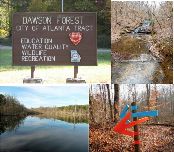
Dawson Forest Exploratory Hike | |||||||
| The Basics: | |||||||
| Event Type: | Explorer | ||||||
| Event Location: |
Dawsonville, GA


| ||||||
| Date(s) & Time: | Sat, Mar 17 2012 9:00 am >> Sat, Mar 17 2012 2:30 pm (Carpool Departure: 8:15 am *log in for location*) | ||||||
| Registration Opens: | Tue, Feb 21 2012 8:00 pm | ||||||
| Registration Cut Off: | Fri, Mar 16 2012 4:00 pm | ||||||
| Event Duration: | 5 Hours 30 Minutes | ||||||
| Difficulty Rating: | D5: Difficult (Exploratory) | ||||||
| Distance: | 12 Miles | ||||||
| Pace: | Fast | ||||||
| Trip Leader(s): | Lauren Joyce T.  Email Trip Leader(s) Email Trip Leader(s)
You must be logged in to get the Trip Leader contact information. | ||||||
| Member Cost: | None | ||||||
| Participant Info: | |||||||
| Who's Invited: | Members Only, 21 And Older Only | ||||||
| Maximum Group Size: | 11 | ||||||
| Minimum Group Size: | 4 | ||||||
| Number Registered So Far: | 9 / 0 (To see who's signed up, log in to the Member Area) | ||||||
| Are Dogs Permitted: | No | ||||||
|
Note: This is an "EXPLORATORY" trip. This means that there are parts of this trip, or perhaps the whole trip, that is new to your Trip Leader(s). However, they are confident that this will not be an issue. This note is here so that you can make an informed decision. When a Trip Leader isn't personally familiar with a trip, there is an increased chance of things not going as planned and you need to be prepared. The Trip Leader may have additional details in the itinerary. | |||||||
| Itinerary: | |||||||
| Let's explore Dawson Forest some more. We've done it twice and had an absolute blast both times. Here's some more info on Dawson Forest and what we'll be doing: The Georgia Nuclear Aircraft Laboratory, also known as AFP No. 67, for Air Force Plant 67 was a United States Air Force test facility located in the Dawson Forest in Dawsonville, Georgia. It was the site of Lockheed's lab for investigating the feasibility of nuclear aircraft. The site was used for irradiating military equipment, as well as the forest to determine the effect of nuclear war, and its effects on wildlife. The area was closed in 1971 and acquired by the city of Atlanta for a second airport, but its topography was determined to be ill-suited for an airport. Documents explaining what went on at the site remain highly classified. Flash forward to 2012: Dawson Forest is filled with trails (horse, biking and hiking) and I've found a map that shows where various components of AFP 67 used to stand. We can look for remnants of various structures such as: "The Hot Cell Building" "Reactor Site" "Cooling Off Area" "Bear Foot Falls" - we know where this is and can use it as a map point Several old bridges and pump houses are noted on the map as well We'll meet at the trailhead of the Atlanta Tract and take the blue/orange trail towards the West. Starting on this trail will point us in the direction of the Reactor Site, Bear Foot Falls and some old bridges. We should also be able to find The Hot Cell Building. We'll decide as a group which trail or trails to take based upon what we think we can find using the trail map and the map I've got showing where the various fun things are. This will be a fun, interactive group hike. We're hoping to hike out for about two and a half hours and then follow the same (or similar trail) back for two and a half hours. Your TL's have been here before and found the trails to be very well marked. We're not doing any major bushwhacking and we're mostly staying on marked trails so we won't end up three states away. Please be prepared to hike a little extra or a little longer depending upon how adventurous we are. Also, there could be some water crossings and we'll decide as a group whether we do them or not, but please be prepared to at least do short, not too difficult water crossings. We will be safe. It's a great space to hike. There is not a lot of elevation change, but there are some climbs that will get your heart pumping. The trails vary from wide gravel roads, compacted dirt, some pavement and lots of wooded trails. It all depends on which way we decide to go as a group. Please be prepared to stay together as a group. I've put ~12 miles down for this hike. It could me more or it could be less based upon how difficult it is to get to certain places. There are horses out there on the main trails and you all know what comes out of the back end of a horse. We just sometimes have to watch our step. We'll hike at a pretty fast pace but we will stop for snacks, pictures and the like. We'll take a short break about halfway through to rest our legs and eat some lunch (pack your own). Stolen from GA Forestry Commision: The Dawson Forest City of Atlanta Tract is a 10,130 acre forest owned by the City of Atlanta and managed by the Georgia Forestry Commission. The Commission plays a Stewardship role for the City by using conservation practices that minimize damage to the Forest caused by human and natural forces. The Forest produces timber, wildlife habitat, clean water into the Etowah River watershed, and many opportunities for persons to experience recreation and education. Trail map: http://www.gatrees.org/ForestManagement/documents/DawsonForestTrai lsMapEMBrev0110.pdf There is a "dry toilet" at the trailhead. | |||||||
| |||||||
| How to Get There: | |||||||
| Event Directions: | Directions from Hwy 400: Take Hwy 400 North or South depending upon starting location to the Dawsonville Outlet mall Red Light. (Turn Left (West) if traveling North or Right (West) if traveling South onto Dawson Forest Road.) Go straight through roundabout, continue straight for approximately 4 miles until the intersection/stop sign. This is Highway 9. Proceed straight through intersection for approximately 1.5 miles to South entrance gate. Proceed through gate and Parking Area/Trailhead will be just ahead on the right. There is a brown sign at the road pointing to trail parking. Once you turn right, follow the road straight back and you will dead end in to a small parking area. There are several signs along the way indicating you are in Dawson Forest. This is about as close as I could figure: 34.35146, - 84.14382 For best directions from your location, open www.maps.google.com and put the bold text below in the seach bar and then use your location as the starting point. 34.35146, -84.14382 | ||||||
| Carpool to Event Distance (round trip): | 60Mile(s) | ||||||
| Carpool Departure Time: | 8:15 am | ||||||
| Carpool Location: | Log in for location | ||||||
| Carpool Directions: | Log in for directions | ||||||
| Carpool Cost: | Estimated cost per vehicle for this event is $24.00 using a reimbursement rate guideline of $0.400 per mile. The total amount should be divided by the number of people in the vehicle, including the driver. This is a guideline, not a rule, for drivers but the cost should not be higher unless there are extenuating circumstances. | ||||||
| Notes: | |||||||
|
* We encourage all members to follow our Etiquette Guidelines while participating in AOC events. | |||||||
Cancellation/Partial Attendance: Please review the AOC cancellation policy. | |||||||
 Calendar of Events
 Event Places