 Print-Friendly Version Print-Friendly Version
|
|
Beech Bottom Trail to Jacks River Falls | |||||||
| The Basics: | |||||||
| Event Type: | Hike | ||||||
| Event Location: |
Cohutta Wilderness


| ||||||
| Date(s) & Time: | Sun, Mar 11 2012 9:30 am >> Sun, Mar 11 2012 2:30 pm (Carpool Departure: 7:30 am *log in for location*) | ||||||
| Registration Opens: | Sun, Mar 4 2012 8:00 pm | ||||||
| Registration Cut Off: | Fri, Mar 9 2012 5:00 pm | ||||||
| Event Duration: | 5 Hours | ||||||
| Difficulty Rating: | D3: Moderate | ||||||
| Distance: | 9.2 Miles | ||||||
| Pace: | Moderate | ||||||
| Trip Leader(s): | Scott Laura  Email Trip Leader(s) Email Trip Leader(s)
You must be logged in to get the Trip Leader contact information. | ||||||
| Member Cost: | None | ||||||
| Participant Info: | |||||||
| Who's Invited: | Members Only, 21 And Older Only | ||||||
| Maximum Group Size: | 12 | ||||||
| Minimum Group Size: | 4 | ||||||
| Number Registered So Far: | 13 / 0 (To see who's signed up, log in to the Member Area) | ||||||
| Are Dogs Permitted: | No | ||||||
| Itinerary: | |||||||
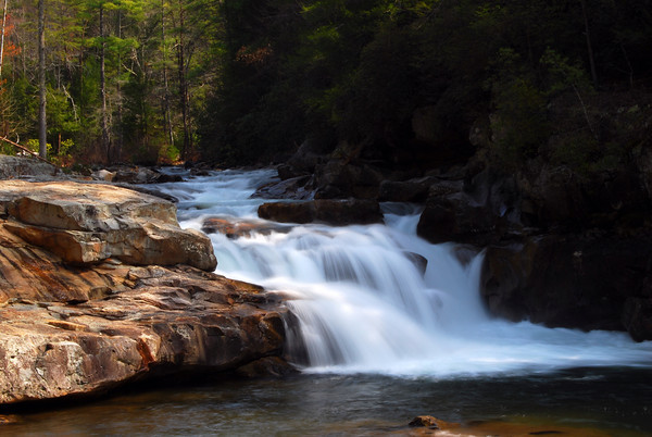
| There are many trails in the Cohuttas that lead to Jacks River Falls, but Beech Bottom is the easiest way to get there. This easy to moderate trail is 4 miles one way with another .6 miles to the falls. We'll take a nice long lunch break to relax, enjoy the falls, and explore. (Thanks to Paula for showing us this trail last year and to Cliff for taking such a great photo of the falls at that event and letting us use it.) | |||||||
| |||||||
| How to Get There: | |||||||
| Event Directions: | - From Chatsworth take US 411 north 13.2 miles to Cisco community and intersection with Old Highway 2 (also known as FS 16). - At .7 mile pass County Road 169 on the right. The pavement ends at 1 mile. Take the right fork at the Y intersection at 1.6 miles. (County Road 210 bears left.) - At 3.2 miles, FS 17 comes in from the right, FS 16 goes left. Follow FS 16 just across the Tennessee state line to the northwestern trailhead of the Jacks River Trail. (Note that FS 51 branches to the right just after crossing the river. Stay left on FS 16.) - From the Jacks River trailhead, take FS 221 in Tennessee (FS 16 in Georgia) 1 mile to FS 62. Turn right and continue 4.5 miles to a parking lot at trailhead. | ||||||
| Carpool to Event Distance (round trip): | 180Mile(s) | ||||||
| Carpool Departure Time: | 7:30 am | ||||||
| Carpool Location: | Log in for location | ||||||
| Carpool Directions: | Log in for directions | ||||||
| Carpool Cost: | Estimated cost per vehicle for this event is $72.00 using a reimbursement rate guideline of $0.400 per mile. The total amount should be divided by the number of people in the vehicle, including the driver. This is a guideline, not a rule, for drivers but the cost should not be higher unless there are extenuating circumstances. | ||||||
| Notes: | |||||||
|
Will this event occur rain or shine? Yes, unless there is severe weather. * We encourage all members to follow our Etiquette Guidelines while participating in AOC events. | |||||||
Cancellation/Partial Attendance: Please review the AOC cancellation policy. | |||||||
 Calendar of Events
 Event Places