 Print-Friendly Version Print-Friendly Version
|
|
Conasauga River Trail | |||||||
| The Basics: | |||||||
| Event Type: | Hike | ||||||
| Event Location: |
Cohutta Wilderness


| ||||||
| Date(s) & Time: | Sun, Apr 22 2012 9:30 am >> Sun, Apr 22 2012 7:30 pm (Carpool Departure: 7:30 am *log in for location*) | ||||||
| Registration Opens: | Fri, Apr 6 2012 8:00 pm | ||||||
| Registration Cut Off: | Fri, Apr 20 2012 5:00 pm | ||||||
| Event Duration: | 10 Hours | ||||||
| Difficulty Rating: | D4: Moderate to Difficult (Exploratory) | ||||||
| Distance: | 12.1 Miles | ||||||
| Pace: | Moderate | ||||||
| Trip Leader(s): | Scott Laura  Email Trip Leader(s) Email Trip Leader(s)
You must be logged in to get the Trip Leader contact information. | ||||||
| Member Cost: | None | ||||||
| Participant Info: | |||||||
| Who's Invited: | Members Only, 21 And Older Only | ||||||
| Maximum Group Size: | 12 | ||||||
| Minimum Group Size: | 3 | ||||||
| Number Registered So Far: | 10 / 0 (To see who's signed up, log in to the Member Area) | ||||||
| Are Dogs Permitted: | No | ||||||
|
Note: This is an "EXPLORATORY" trip. This means that there are parts of this trip, or perhaps the whole trip, that is new to your Trip Leader(s). However, they are confident that this will not be an issue. This note is here so that you can make an informed decision. When a Trip Leader isn't personally familiar with a trip, there is an increased chance of things not going as planned and you need to be prepared. The Trip Leader may have additional details in the itinerary. | |||||||
| Itinerary: | |||||||
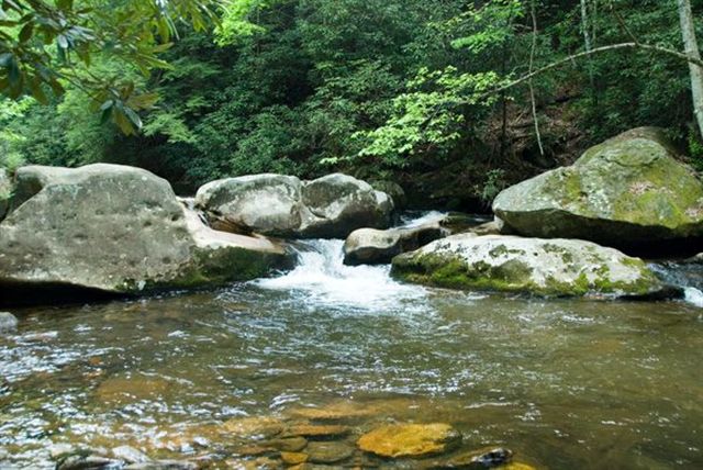
The Conasauga River Trail is a 12.1 mile shuttle hike in the Cohutta Wilderness. This trail crosses the river 38 times passing waterfalls, rushing shoals, deep pools, giant boulders, beaver ponds, rhododendron, hemlocks, and pine. After dropping off half of our vehicles at the Conasauga River trailhead near Murrays Lake, we will drive to the Betty Gap parking lot to begin our hike. We will be hiking primarily downhill on a gradual slope as we follow the river downstream until we reach the trail's end. Please be prepared to get very wet. You must bring river shoes and hiking poles for the numerous river crossings with water levels that at times could be higher than waist deep. (Special thanks to Scott Sanders for his write-up, directions, GPS route, and photos on Backpacker.com) | |||||||
| |||||||
| How to Get There: | |||||||
| Event Directions: | Detailed directions to both trailhead parking lots will be provided at the carpool. | ||||||
| Carpool to Event Distance (round trip): | 180Mile(s) | ||||||
| Carpool Departure Time: | 7:30 am | ||||||
| Carpool Location: | Log in for location | ||||||
| Carpool Directions: | Log in for directions | ||||||
| Carpool Cost: | Estimated cost per vehicle for this event is $72.00 using a reimbursement rate guideline of $0.400 per mile. The total amount should be divided by the number of people in the vehicle, including the driver. This is a guideline, not a rule, for drivers but the cost should not be higher unless there are extenuating circumstances. | ||||||
| Notes: | |||||||
|
Will this event occur rain or shine? No * We encourage all members to follow our Etiquette Guidelines while participating in AOC events. | |||||||
Cancellation/Partial Attendance: Please review the AOC cancellation policy. | |||||||
 Calendar of Events
 Event Places