(Day 1) - Arrive at the airport (discuss with trip leader, some may be leaving earlier to do other things prior to this trip). If you're just doing this, then you would likely need to fly into Mammoth Lakes, CA to be picked up on this day. Likely at Bishop, CA Ranger Station, trip leader will pick up permits (already reserved and paid) and purchase fuel canisters and rent bear canisters for everyone. Drive to Onion Valley campsite, 13 miles west of Independence, CA. Setup camp here at 9,200 foot elevation and get ready for 3 day backpacking trip into Kings Canyon National Park. Store all food in bear canisters. No food is to be left in cars or tents as we will be entering an active bear area.
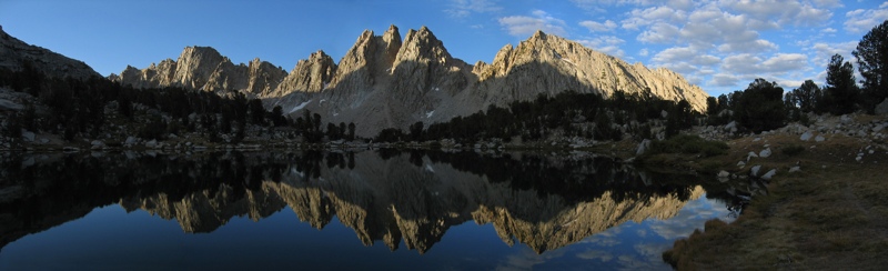
(Day 2) - Break camp early and backpack about 8 miles to Charlotte Lake, Kings Canyon National Park, involving about 2,600' of elevation gain. We will pass several beautiful mountain lakes, go over Kearsarge Pass at 11,823' with its beautiful views of Kearsarge Lakes and Bullfrog Lake in the distance, as well as the Kearsarge Pinnacles. Then we will go down to Charlotte Lake at 10,370', where we will camp. Some of us may decide to do some hiking with day packs before settling down for the evening.
(Day 3) - The current plan is to do a day hike to Rae Lakes, returning to Charlotte Lake to camp again, or possibly backpacking a short distance to Kearsarge Lakes area to camp. The day hike to Rae Lakes will be about 5.5 miles, passing over Glen Pass at 11,978', and on to Rae Lakes at 10,696'. After some exploring around the several Rae Lakes, we return the same way to Charlotte Lake for a trip of 11-13 miles, with about 3,000' of elevation gain.
(Day 4) - We arise early and backpack 8 miles to our cars over Kearsarge Pass and back down to Onion Valley with about 1,400' of elevation gain. If desired, some may go down into Kearsarge Lakes area for some better views. We pack our gear in the cars and drive to Lone Pine, CA and on to our campsite at Whitney Portal, where we will spend the night.
(Day 5) - We arise early and start our day hike of 11 miles and 6200' of elevation gain from Whitney Portal via the Mt. Whitney Trail to the summit of Mt. Whitney, the tallest mountain in the contiguous United States, at 14,505'. We return the same way for a 22 mile hike round trip in 10-13 hours. We get in our cars and return to Lone Pine for our individual choices of lodging. Options include camping, a hostel, and hotels.
(Day 6) - Check out and return home. |
|
Costs:
1) The Kings Canyon backcountry permit for eight people is $36.00, to be divided among participants, if fewer than eight people, go we'll divide it up among the number who go. Payable to trip leader before May 15.
2) The Mt. Whitney permit for eight people is $126.00, to be divided among participants, if fewer than eight people, go we'll divide it up among the number who go. Payable to trip leader before May 15.
3) The camping permit for Tuesday night is $50 , to be divided among participants, if fewer than eight people, go we'll divide it up among the number who go. Payable to trip leader before May 15.
4) The camping permit for Friday night is $48, to be divided among participants, if fewer than eight people, go we'll divide it up among the number who go. Payable to trip leader before May 15.
5) Individual lodging accomodations for Saturday night.
6) Bear canister rental is about $5. Payable to trip leader before May 15.
7) Fuel canisters will be about $6. Payable to trip leader before May 15.
8) There may be park entrance fees. Payable to trip leader before May 15.
9) Expect to be eating out on Tuesday and Saturday night and Sunday.
10) Car rental fees and gas to be shared. Payable after transportation details are determned.
11) Airline ticket.
We will have a planning/details meeting for this trip before the AOC social on May 8.
Those who have questions about their abilities and/or any details about the trip are encouraged to talk to the trip leaders. If you don't have recent D5 hiking and backpacking experience with AOC, you'll need trip leader approval.
Trip leaders advise participants to make transportation reservations as soon as possible. Copy of airline ticket is to be emailed to trip leaders by May 20 as proof of commitment. Proof of reservations for accomodations on Saturday night is also required by May 20. If you haven't done these things by May 20, you'll be moved to the waiting list.
Accommodations: Camping at Onion Valley on the 1st night. Backpacking nights 2 - 3. Camping in Lone Pine on the 4th night. Optional camping or staying in a hostel or hotel in Lone Pine on the 5th night. We'll talk about this in more detail later when we see what everyone wants to do.
Transportation: Each person will be responsible for his or her own airfare. Your TLs will provide their arrival times and location(s) shortly after registration opens, and thereafter initiate communication with all participants, to assist in determining if ride sharing is possible from the airport. Mammoth Lakes is the closest airport. We will have two rental cars for transportation to our events. You will be expected to share car rental and gas cost equally with those using your rental vehicle.
Weather: We will be hiking and camping at high altitude with temperatures possibly in the 30's or lower at night. Winds at the top of Mt. Whitney may reach 30 mph or higher. Although not likely, It is possible that there may be a snowstorm as we hike. There is a chance that there may be some snow on the trails, though we do not expect to need any snowshoes or crampons. Rain is possible, although not expected. Sun is more dangerous at higher altitudes and protection should be used.
Exploratory nature of Events: For your TLs, this event promises to be a glorious week of exploration in an exciting environment we have never visited. However, understand that your TLs have never been here! We have never hiked these trails. While we have studied maps and trail guides, and will have these maps and trail guides in hand while hiking, you should be in sufficient shape to hike additional mileage if we miss a turn or hike the wrong route.
Changes: Details of this event, such as the specific trail hiked, are subject to change based upon an assessment of a multitude of variables, such as weather, conditions, crowds and new information.
|
 Print-Friendly Version
 Email Trip Leader(s)
 Calendar of Events
 Event Places