 Print-Friendly Version Print-Friendly Version
|
Rabun Bald, Three Forks, Holcomb Creek Falls, Ammons Falls, and a few other falls - 3 distinct trails, 1 event | |||||||
| The Basics: | |||||||
| Event Type: | Hike | ||||||
| Event Location: |
About 9 miles east of Clayton, Ga


| ||||||
| Date(s) & Time: | Wed, May 16 2012 10:30 am >> Wed, May 16 2012 6:00 pm (Carpool Departure: 8:00 am *log in for location*) | ||||||
| Registration Opens: | Mon, May 14 2012 1:59 pm | ||||||
| Registration Cut Off: | Tue, May 15 2012 8:30 pm | ||||||
| Event Duration: | 7 Hours 30 Minutes | ||||||
| Difficulty Rating: | D5: Difficult | ||||||
| Distance: | 12.5 Miles | ||||||
| Pace: | Moderate | ||||||
| Trip Leader(s): | Mark Email Trip Leader(s) Email Trip Leader(s)
You must be logged in to get the Trip Leader contact information. | ||||||
| Member Cost: | None | ||||||
| Participant Info: | |||||||
| Who's Invited: | Members Only, 21 And Older Only | ||||||
| Maximum Group Size: | 8 | ||||||
| Minimum Group Size: | 2 | ||||||
| Number Registered So Far: | 5 / 0 (To see who's signed up, log in to the Member Area) | ||||||
| Are Dogs Permitted: | No | ||||||
| Itinerary: | |||||||
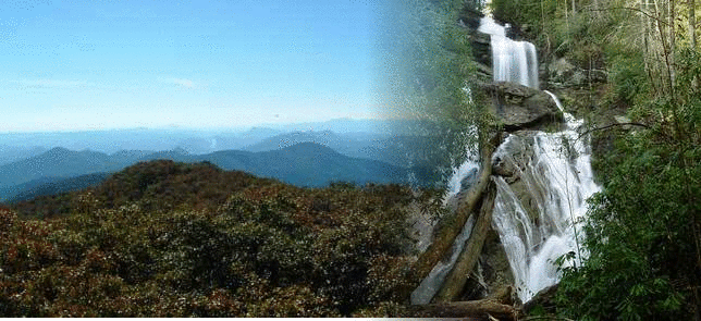
Yes... you read that title correctly. This hike is will be packed with adventure and sightseeing opportunities! Three separate trails - all within a few miles. We'll hike to the second highest peak in Georgia with spectacular 360 degree views, go through some of the prettiest and diverse forest to see several waterfalls (two over 100 feet tall), and then visit one of the most lush and pretty areas in the state. Please read ALL sections of this event posting prior to signing up for this hike. There is important information throughout concerning the difficulty, what to expect, what not to expect, and how to be prepared.
| |||||||
| |||||||
| How to Get There: | |||||||
| Event Directions: | There is limited to no cell phone coverage in the area of this event, the drive time is approximate, and the order we do these hikes is subject to modification. Therefore, this will be a carpool only event. If you will not be traveling from the Atlanta area and feel that you have a legitimate need to meet at the event, you will need to contact the trip leader for specific directions/instructions. | ||||||
| Carpool to Event Distance (round trip): | 220Mile(s) | ||||||
| Carpool Departure Time: | 8:00 am | ||||||
| Carpool Location: | Log in for location | ||||||
| Carpool Directions: | Log in for directions | ||||||
| Carpool Cost: | Estimated cost per vehicle for this event is $88.00 using a reimbursement rate guideline of $0.400 per mile. The total amount should be divided by the number of people in the vehicle, including the driver. This is a guideline, not a rule, for drivers but the cost should not be higher unless there are extenuating circumstances. | ||||||
| Notes: | |||||||
|
There is no reason not to bring enough water, snacks, and food on this hike. This hike will be broken up into three sections, with us returning to the cars after each. So, bring plenty of water (even extra), snacks, and lunch, because half of it can be left in the car for the second and third portions of the hike - there will not be the burden to carry it ALL at any given time. We will be covering a lot of ground, and the expected duration in the wilderness will be about 7 - 8 hours. * We encourage all members to follow our Etiquette Guidelines while participating in AOC events. | |||||||
Cancellation/Partial Attendance: Please review the AOC cancellation policy. | |||||||
 Calendar of Events
 Event Places