 Print-Friendly Version Print-Friendly Version
|
|
Rabun Bald & Bartram Trail Overlook | |||||||
| The Basics: | |||||||
| Event Type: | Hike | ||||||
| Event Location: |
Clayton, GA


| ||||||
| Date(s) & Time: | Sat, May 19 2012 8:15 am >> Sat, May 19 2012 6:00 pm (Carpool Departure: 8:15 am *log in for location*) | ||||||
| Registration Opens: | Tue, May 15 2012 6:05 pm | ||||||
| Registration Cut Off: | Fri, May 18 2012 7:30 am | ||||||
| Event Duration: | 9 Hours 45 Minutes | ||||||
| Difficulty Rating: | D5: Difficult | ||||||
| Distance: | 12 Miles | ||||||
| Pace: | Moderate | ||||||
| Trip Leader(s): | Doug L Email Trip Leader(s) Email Trip Leader(s)
You must be logged in to get the Trip Leader contact information. | ||||||
| Member Cost: | None | ||||||
| Participant Info: | |||||||
| Who's Invited: | Members Only, 21 And Older Only | ||||||
| Maximum Group Size: | 8 | ||||||
| Minimum Group Size: | 2 | ||||||
| Number Registered So Far: | 3 / 0 (To see who's signed up, log in to the Member Area) | ||||||
| Are Dogs Permitted: | No | ||||||
| Itinerary: | |||||||
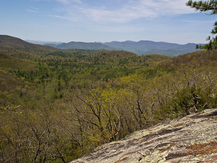
This hike will start at the Three Forks trail on Hale Ridge road. We will go up this trail 3 miles to the tower on top of Rabun Bald. We will turn left on the Bartram and go down to Saltrock Gap, skirt the top of Flattop Mountain and go down to a good overlook where we will have lunch while enjoying the view. The tower on Rabun Bald offers a 360 degree view of the surrounding mountains. The overlook offers one of the most unspoiled views on the Bartram trail. At 12 miles and 3800 feet of elevation gain this will be a strenuous hike. The initial ascent of 2200 feet is one of the longest uphill stretches in Georgia with the last .5 mile being particularly steep. Faster hikers can go ahead but we will regroup at the tower, gaps and overlook to avoid getting too strung out. I have done this hike in 5.5 hours but depending on the group it could take as long as 8. The drive is a little over 2 hours each way not counting the usual break on the way up or dinner on the way back. After the hike we will stop in Clayton for dinner if enough people are interested. NOTES: | |||||||
| |||||||
| How to Get There: | |||||||
| Event Directions: | Directions to trailhead will be given at carpool (or via email if "meeting at event"). | ||||||
| Carpool to Event Distance (round trip): | 170Mile(s) | ||||||
| Carpool Departure Time: | 8:15 am | ||||||
| Carpool Location: | Log in for location | ||||||
| Carpool Directions: | Log in for directions | ||||||
| Carpool Cost: | Estimated cost per vehicle for this event is $68.00 using a reimbursement rate guideline of $0.400 per mile. The total amount should be divided by the number of people in the vehicle, including the driver. This is a guideline, not a rule, for drivers but the cost should not be higher unless there are extenuating circumstances. | ||||||
| Notes: | |||||||
|
Because this a D5 event, if you have not very recently completed some tough AOC hikes, I will be contacting you to determine your level of fitness and experience to make sure this is the right hike for you. This hike will be cancelled if the chance of thunderstorms is 50% or greater or a steady all day rain is forecast. I prefer hiking with a small group. If this event does fill up I will not increase the group size by adding people from the waiting list unless someone that is registered drops out. The last 6 miles of the drive will be on a maintained forest service dirt road with some potholes and ruts. I made it to this trailhead in a small car with low ground clearance several times without any trouble but want to warn anybody that does not like driving on dirt roads. * We encourage all members to follow our Etiquette Guidelines while participating in AOC events. | |||||||
| Cost Includes: | NA | ||||||
Cancellation/Partial Attendance: Please review the AOC cancellation policy. *Note: NA | |||||||
 Calendar of Events
 Event Places