 Print-Friendly Version Print-Friendly Version
|
|
Hiking | |||||
| The Basics: | |||||
| Event Type: | Hike | ||||
| Event Location: | Standing Indian | ||||
| Date(s) & Time: | Sat, Jan 27 2007 9:00 am >> N/A | ||||
| Registration Opens: | Mon, Jan 1 2007 12:00 am | ||||
| Registration Cut Off: | Thu, Jan 25 2007 11:59 pm | ||||
| Event Duration: | per itinerary | ||||
| Difficulty Rating: | D5: Difficult | ||||
| Trip Leader(s): | d merat Email Trip Leader(s) Email Trip Leader(s)
You must be logged in to get the Trip Leader contact information. | ||||
| Member Cost: | None | ||||
| Participant Info: | |||||
| Who's Invited: | Members Only, 21 And Older Only | ||||
| Maximum Group Size: | 12 | ||||
| Minimum Group Size: | 4 | ||||
| Number Registered So Far: | 13 / 0 (To see who's signed up, log in to the Member Area) | ||||
| Are Dogs Permitted: | No | ||||
| Itinerary: | |||||
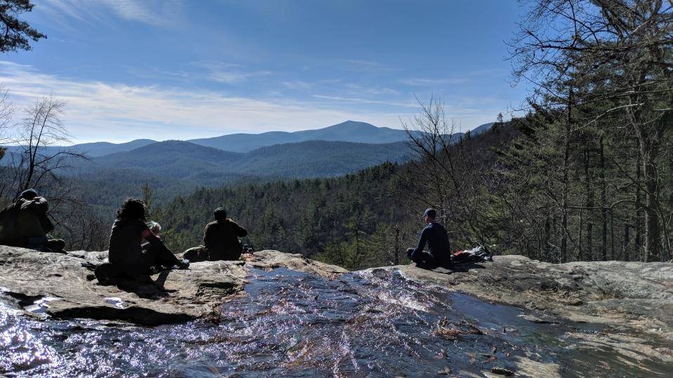
| Strenuous 9 Miles Standing Indian Mountain is the highest point along the Appalachian Trail south of the Smokey Mountains. The bare spot on top of Standing Indian is not large, but it provides a brilliant vista at the Standing Indian Basin. From this point, you are looking to the west and can see several miles on a clear day. Little Annie Lake, less than 15 miles away, is visible beyond seven tree-filled mountain ridges, including Chunky Gal Mountain, which rises high above the other ridges. To the west, you can see the 4,132-foot peak at Rich Knob and the 4,588-foot peak at Hightower Bald. Located in the Nantahala Wilderness Area, Standing Indian Mountain is the highest point along the Appalachian Trail south of the Smokey Mountains. Views from the top can be spectacular regardless of the time of year. We will make a loop using 3 trails: Beech Creek trail-up hill, with the last 20 minutes straight up the side of standing Indian. Appalachian Trail-ridgeline to the top, down hill the rest of the way. Deep Gap Trail- Gentle down hill to steep down hill then flat. | |||||
| |||||
| How to Get There: | |||||
| Event Directions: | Tallulah & Nantahala Wilderness Areas 9:00 a.m. - Indian Trail P&R (I-85 N to Exit 101, turn left over the bridge and turn right into Park-n-Ride). Directions to trailhead: 85 N to 985 N to 23/365 N to 23/441 N this will take us into Clayton GA. In Clayton turn left onto 76 W, travel about 15 minutes. Right onto Persimmon, left onto Tallulah road , travel about 20 minutes, or until the road ends. | ||||
| Notes: | |||||
|
Are Dogs Permitted? No. Will this event occur rain or shine? Yes. NOTE: Please be considerate of others. If you sign-up and cannot attend, please e-mail the trip leader, so others that may be on a waiting list may attend. E-mail the trip leader to be put on a waiting list if the trip is at the max number of attendees. * We encourage all members to follow our Etiquette Guidelines while participating in AOC events. | |||||
| Cost Includes: | Please share gas expense with your carpool driver. | ||||
Cancellation/Partial Attendance: Please review the AOC cancellation policy. | |||||
 Calendar of Events
 Event Places