 Print-Friendly Version Print-Friendly Version
|
|
Betty Creek to Beech Gap and back | |||||||
| The Basics: | |||||||
| Event Type: | Hike | ||||||
| Event Location: |
Standing Indian area, near Franklin, NC


| ||||||
| Date(s) & Time: | Sat, Aug 25 2012 7:30 am >> Sat, Aug 25 2012 9:30 pm (Carpool Departure: 7:30 am *log in for location*) | ||||||
| Registration Opens: | Tue, Aug 21 2012 10:03 pm | ||||||
| Registration Cut Off: | Fri, Aug 24 2012 12:00 pm | ||||||
| Event Duration: | per itinerary | ||||||
| Difficulty Rating: | D5: Difficult | ||||||
| Distance: | 14 Miles | ||||||
| Pace: | Moderate | ||||||
| Trip Leader(s): | Dorothea Email Trip Leader(s) Email Trip Leader(s)
You must be logged in to get the Trip Leader contact information. | ||||||
| Member Cost: | None | ||||||
| Participant Info: | |||||||
| Who's Invited: | Members Only, 21 And Older Only | ||||||
| Maximum Group Size: | 9 | ||||||
| Minimum Group Size: | 2 | ||||||
| Number Registered So Far: | 5 / 0 (To see who's signed up, log in to the Member Area) | ||||||
| Are Dogs Permitted: | No | ||||||
| Itinerary: | |||||||
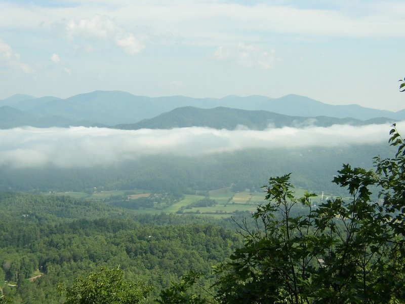
This section of the AT, lying in the curve of the horseshoe formed by Standing Indian and Albert Mountains, sees little use by the AOC, although it is a comfortable and pretty hike, undulating gently across varied terrain that features several streams, several gaps, and one 180-degree view to the east. With about 1800 ft in elevation gain in total, it offers a pleasant outing in the woods. I can’t remember how long it took the previous times I have hiked it, but I would allow seven hours. On the photo, taken from Black Rock State Park, Standing Indian is the highest peak. Trace a line towards the right down its back and then dropping more steeply to Beech Gap. From there the trail continues to the right (not visible) and then swings to the north. If people are interested, we will have supper in Clayton. Since I will be meeting the carpoolers from Atlanta in Clayton, I will be asking for a volunteer to coordinate the carpooling at the Indian Trail park and ride. | |||||||
| |||||||
| How to Get There: | |||||||
| Event Directions: | From the Indian Trail park & ride, take I-85 North. After 11 miles bear left to take I-985 North. This road will change to GA 365, US 441, and US 23. Stay on it for 75 miles, then stop at the Burger King in Clayton for a pit-stop and to meet the leader. Once back on the 441, it is 21 miles to Franklin. Make a left onto US 64 West and travel 11 miles, then turn left on to S.R. 1448 (Old US 64). Continue on S.R. 1448 to Wallace Gap and turn right on to FS 67, following the sign to Standing Indian Campground. Continue for 8.8 miles to the parking area at Betty Creek Gap on your right. We will be returning to Clayton via a different route. | ||||||
| Carpool to Event Distance (round trip): | 240Mile(s) | ||||||
| Carpool Departure Time: | 7:30 am | ||||||
| Carpool Location: | Log in for location | ||||||
| Carpool Directions: | Log in for directions | ||||||
| Carpool Cost: | Estimated cost per vehicle for this event is $96.00 using a reimbursement rate guideline of $0.400 per mile. The total amount should be divided by the number of people in the vehicle, including the driver. This is a guideline, not a rule, for drivers but the cost should not be higher unless there are extenuating circumstances. | ||||||
| Notes: | |||||||
|
If you have not recently completed comparable AOC hikes, I will be contacting you to determine whether this is the right hike for you * We encourage all members to follow our Etiquette Guidelines while participating in AOC events. | |||||||
Cancellation/Partial Attendance: Please review the AOC cancellation policy. | |||||||
 Calendar of Events
 Event Places