 Print-Friendly Version Print-Friendly Version
|
|
Slow and Steady: Andrews Cove to Tray Mountain | |||||||
| The Basics: | |||||||
| Event Type: | Hike | ||||||
| Event Location: |
Chattahoochee National Forest


| ||||||
| Date(s) & Time: | Tue, Oct 9 2012 11:00 am >> Tue, Oct 9 2012 11:45 am (Carpool Departure: 11:00 am *log in for location*) | ||||||
| Registration Opens: | Wed, Oct 3 2012 8:10 pm | ||||||
| Registration Cut Off: | Mon, Oct 8 2012 5:00 pm | ||||||
| Event Duration: | Per Itinerary | ||||||
| Difficulty Rating: | D4: Moderate to Difficult | ||||||
| Distance: | 10.4 Miles | ||||||
| Pace: | Leisurely | ||||||
| Trip Leader(s): | Tony C David M  Email Trip Leader(s) Email Trip Leader(s)
You must be logged in to get the Trip Leader contact information. | ||||||
| Member Cost: | None | ||||||
| Participant Info: | |||||||
| Who's Invited: | Members Only, 21 And Older Only | ||||||
| Maximum Group Size: | 10 | ||||||
| Minimum Group Size: | 4 | ||||||
| Number Registered So Far: | 7 / 0 (To see who's signed up, log in to the Member Area) | ||||||
| Are Dogs Permitted: | No | ||||||
| Itinerary: | |||||||
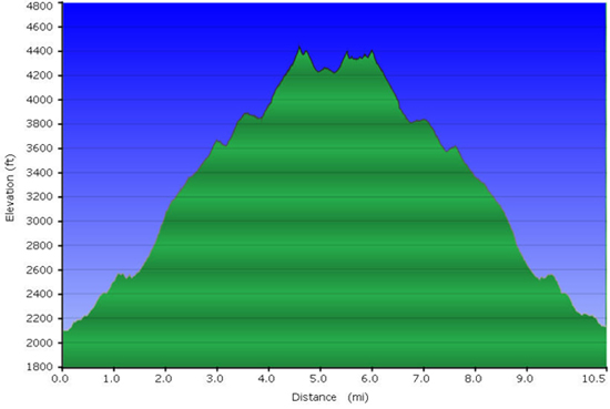
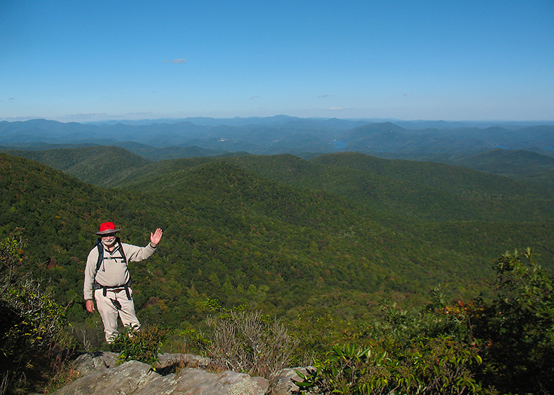
--Note: pushed back a day because of rain forecast for Monday -- First of all, props to Sam L for starting this “Slow and Steady” series, and I hope to lead a few more of these myself this fall and winter for those who enjoy a long hike with a leisurely to moderate pace. These are just an alternative to the faster, "fitness" hikes, which are great too, but not always in the mood for one of those. So we will take our time with this one, esp on the uphill sections. Andrews Cove to Tray Mtn has become my official annual hike to celebrate the arrival of cooler fall weather. It seems like it gets pushed back father every year as summer temps stick around longer, but the forecast for Monday is looking great....highs in the upper 50s at the elevations where we will be most of the day...so let's get out there and enjoy it. Standing at 4430', Tray Mountain is the fifth highest in GA (using 300' prominence rule). It is a very popular hiking destination on the AT, and for good reason...a challenging climb and the effort is well rewarded with beautiful views along the trail and of course at the summit and additional overlooks. This route is sometimes a D5, but making it a D4 on this occasion because of the slower pace. I do believe that anyone in D4 shape will be just fine on it. You could probably This trail is easy to follow, so faster hikers can hike ahead during most sections, but I'll ask that everyone regroup at each trail junction. If you don't like to stand and wait, you can hike back to the tail end of the group to keep moving and get some extra mileage in. I've done this before on my faster days and works well. But to give you more guidance on what the slow or "leisurely" pace means, I would say 1.5 to 2 mph on the uphills and maybe 2 to 2.5 mph on the downhills. So if you are a really fit and fast D5 hiker, you are going to be standing around and waiting a good bit..or getting in a good bit of extra mileage in...one or the other. So keep that in mind before signing up to make sure that you will enjoy this kind of hike. Andrews Cove sits at about 2000', about 900' below Unicoi Gap, where Tray Mtn hikes often begin. This route has a longer initial climb (and ending descent) but does save you from having to do the 1000' climb up Rocky Mtn twice. That's another reason to take your time on the long climb up because once you get up there, it is just about all dowhill the rest of the way. A few short climbs but nothing that challenging. But refer to the elevation profile below for the full story. From the trailhead, we will hike up to Indian Grave Gap and then jump on the Appalachian Trail (AT) to the Tray summit. Then down just a bit on the other side to the AT shelter for some views. From there we will have about a 200' climb back to the top and a detour to the secret overlook....ok maybe not so "secret" at this point, but still one of the best views in the state. We will take a long lunch break here and then we will head back down. I enjoy hiking around sunset time, so we are not starting this one so early in the morning and will try to time it to finish at around 7:30 pm (sunset is at 7:12 PM). I doubt we'll end up in the dark, but bring a headlamp just in case we cut it close. I have a GPS, compass, maps, and have hiked this trail many times before, so no big deal if we do finish up just a little later. But should be a fun hike on a crisp, cool autumn day...nothing better. Total distance is approx 10.4 miles. (and 2900 sounds like a lot of ascent for a D4, but the slower pace really does make a big difference. This should be less strenuous than some D4 fitness hikes that the AOC often offers) PLEASE NOTE: If rain is forecast (or the forecast high suddenly jumps by 10 degrees), the hike will be rescheduled for a later date. The point for this one is to be a nice cool day in the mtns. Because this a challenging D4 event, if you have not very recently completed some tough AOC hikes, I may be contacting you to determine if this is the right hike for you. Because there is very limited parking at the trailhead, I am making this carpool only without the usual "Meet at Event" option. And if the parking area is full, we may actually have to start at Unicoi Gap after all...either that or Indian Grave Gap, so just be aware that the plan may change in that regard (although unlikely).
| |||||||
| |||||||
| How to Get There: | |||||||
| Event Directions: | Directions to trailhead will be given at carpool. | ||||||
| Carpool to Event Distance (round trip): | 150Mile(s) | ||||||
| Carpool Departure Time: | 11:00 am | ||||||
| Carpool Location: | Log in for location | ||||||
| Carpool Directions: | Log in for directions | ||||||
| Carpool Cost: | Estimated cost per vehicle for this event is $60.00 using a reimbursement rate guideline of $0.400 per mile. The total amount should be divided by the number of people in the vehicle, including the driver. This is a guideline, not a rule, for drivers but the cost should not be higher unless there are extenuating circumstances. | ||||||
| Notes: | |||||||
|
* We encourage all members to follow our Etiquette Guidelines while participating in AOC events. | |||||||
Cancellation/Partial Attendance: Please review the AOC cancellation policy. | |||||||
 Calendar of Events
 Event Places