Intermediate Orienteering Practice at Sweetwater Creek State Park
|
|
The Basics: |
| Event Type: |  | Adventure | |
|
Event Location: | |
30 min W of Atlanta, near I-20 Thornton Rd exit
| |
| Date(s) & Time: | | Sun, Sep 16 2012
9:30 am >> Sun, Sep 16 2012 1:30 pm (Carpool Departure: 9:30 am *log in for location*)
| |
| Registration Opens:
| |
Sun, Sep 9 2012 9:30 pm
| |
| Registration Cut Off:
| |
Sat, Sep 15 2012 9:30 pm
| |
| Event Duration: | | 4 Hours | |
| Difficulty Rating: | | D3: Moderate | |
| Distance: | | 4 Miles | |
| Pace: | | Leisurely | |
Trip Leader(s):
| | Charlie Cottingham
Harry Falise
 Email Trip Leader(s) Email Trip Leader(s)
You must be logged in to get the Trip Leader contact information.
| |
| Member Cost: | | None |
|
| Participant Info: |
| Who's Invited: | |
Members Only, 21 And Older Only
| |
| Maximum Group Size: | | 12 |
| Minimum Group Size: | | 4 |
| Number Registered So Far: | |
6 / 0 (To see who's signed up, log in to the Member Area)
|
| Are Dogs Permitted: | |
No
|
|
| Itinerary: |
IN A NUTSHELL: This group orienteering practice event is intended primarily for those AOCers who already have had some experience with topographic maps, compasses and the sport of orienteering, but also is suitable for map & compass "novices" who feel comfortable with occasional off-trail hiking through rough terrrain.
The event will be held in conjunction with the Sweetwater Ck State Park orienteering meet on Sun Sep 16th, hosted by Charlie's and Harry's friends in the GA Orienteering Club (GAOC).
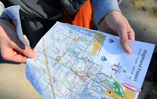
Our intent will be to orienteer together the intermediate "Orange" orienteering course at an easy to moderate pace. Along the way we'll take the time to discuss alternate strategies for reaching each successive "control flag," and take an appropriate route accordingly. On an Orange course the control flags are typically hung at terrain features that are 50 to 100 meters from the nearest trail, lake frontage, etc.
EVENT PLAN: We'll all gather initially just inside the entrance of the Walmart Parking lot near the I-20 Thornton Rd exit - see easy detailed directions below. After introductions we'll carpool and/or caravan about 3 miles to the O Meet "Start" location inside the State Park.
After checking in informally at the O Meet we'll conduct a brief refresher for our AOC "subgroup" in how to use a compass in conjunction with a topographic map to find our way confidently through unfamiliar terrain. We'll also discuss the basics of the sport of Orienteering and register as a "wayfaring group" —see more below.
We AOCers will then set off together on the “Orange" (intermediate) O course, practicing our map & compass skills to locate about ten partially hidden “control flags” whose locations are shown on our topo map. After reaching each flag we’ll take a look at our map and "clue sheet" and discuss appropriate “attack strategies” to find the next flag in the course’s sequence.
We’ll share a couple of copies of the GAOC's Sweetwater Ck State Park topographic map specially marked for the Orange course. Bring your own compass if you have one – otherwise you may use one of our free “loaner” compasses. We plan to take a relaxed “wayfaring” pace, although many O Meet competitors that day will be trying for max. speed between control flags.
After we finish the Orange course you're welcome (on your own) to register for a different course and locate several or all of those flags. Beginning at about 3:00 pm the control flags will be picked up by O Club volunteers, so it's important to check in back at the Start by then.
WHAT IS ORIENTEERING? It’s a sport that blends the fun of a scavenger hunt with the adventure of navigating between flagged checkpoints in unfamiliar natural terrain. We “orienteer” using a detailed topographic map, a simple magnetic compass, and our judgment as to which route to take between partially hidden white & orange control flags whose positions and surrounding land & water features are shown on the map. Before tackling an O course we’re also usually given a "clue sheet" that describes the main topographic features in the immediate vicinity where each flag is hung.
We’re fortunate to have in Atlanta a very active and friendly not-for-profit “O” club. GA Orienteering Club volunteers organize year-round “O Meets” and “O” education programs at parks and wilderness preserves throughout north Georgia. The general public is welcome to participate in GAOC events without formal membership. Membership dues are only $8 per year (or $12 per couple, $15 per family).
For more on the GA Orienteering Club go to:
http://gaorienteering.org
The O Club has an free online "Tutorial" for beginners at:
http://gaorienteering.org/Education/BeginnerGuide/introduction.htm
|
|
Required Items to Bring:
• Comfortable broken-in Athletic Shoes or Hiking Boots with wool-blend or synthetic Socks. Avoid 100% cotton.
• Lightweight comfortable Clothing layers appropriate for the weather. Long Pants are suggested, since we’ll be occasionally walking off-trail through the forest.
• Compass if you have one. (A simple "protractor-type" compass on a clear plastic rectangular base. They're available for about $10 or less at Wal-Mart, Sports Authority, REI, etc. We'll have several "loaner" compasses on hand for you to share if it's inconvenient for you to bring one.
• Water: About 1 Quart, in “Camelbak” or bottles inside a small daypack/fanny pack.
• $3 in Cash for the CRNRA self-serve Parking Fee envelope if you drive.
| | Recommended Items to Bring:
Use our Event Checklists to make sure you have everything you need.
• Consider carrying a Light Daypack for stashing unneeded layers as you warm up and for your water bottle, camera, snack, emergency rain gear, etc.
• Optional: Trekking Pole(s) or Hiking Stick.
• Optional: Your Camera!
| |
|
| How to Get There: |
| Event Directions: | | ALL PLEASE MEET at CARPOOL LOCATION - SEE BELOW. | |
| Carpool to Event Distance (round trip): | | 6Mile(s) |
| Carpool Departure Time: | |
9:30 am
|
| Carpool Location: | |
Log in for location
|
| Carpool Directions: | |
Log in for directions
|
| Carpool Cost: | |
Estimated cost per vehicle for this event is $2.40 using a reimbursement rate guideline of $0.400 per mile. The total amount should be divided by the number of people in the vehicle, including the driver. This is a guideline, not a rule, for drivers but the cost should not be higher unless there are extenuating circumstances.
|
|
| Notes: |
|
|
|
Cancellation/Partial Attendance: Please review the AOC cancellation policy. |
 Print-Friendly Version
 Calendar of Events
 Event Places