 Print-Friendly Version Print-Friendly Version
|
|
Siler Bald & Wayah Bald on the AT | |||||||
| The Basics: | |||||||
| Event Type: | Hike | ||||||
| Event Location: |
west of Franklin, NC


| ||||||
| Date(s) & Time: | Sat, Sep 15 2012 8:00 am >> Sat, Sep 15 2012 8:00 pm (Carpool Departure: 8:00 am *log in for location*) | ||||||
| Registration Opens: | Mon, Sep 10 2012 10:00 pm | ||||||
| Registration Cut Off: | Thu, Sep 13 2012 6:00 pm | ||||||
| Event Duration: | per itinerary | ||||||
| Difficulty Rating: | D5: Difficult | ||||||
| Distance: | 12 Miles | ||||||
| Pace: | Moderate | ||||||
| Trip Leader(s): | Dorothea Ofelia  Email Trip Leader(s) Email Trip Leader(s)
You must be logged in to get the Trip Leader contact information. | ||||||
| Member Cost: | None | ||||||
| Participant Info: | |||||||
| Who's Invited: | Members Only, 21 And Older Only | ||||||
| Maximum Group Size: | 9 | ||||||
| Minimum Group Size: | 2 | ||||||
| Number Registered So Far: | 5 / 0 (To see who's signed up, log in to the Member Area) | ||||||
| Are Dogs Permitted: | Yes | ||||||
| Itinerary: | |||||||
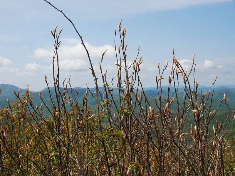
Two magnificent views on a figure-8 hike. The center of the figure 8 is the parking lot at Wayah Gap (~4200 ft). To make the first loop we ascend Siler Bald (5216 ft), where we will enjoy a 360-degree view on a wide-open grassy crown, after which we return to Wayah Gap (4 miles, 2 hours). For the second loop we cross the road and ascend Winespring Mountain and continue along the ridge to Wayah Bald (5350 ft), where we enjoy another almost 360-degree view from the recently restored fire tower, before returning to Wayah Gap (8 miles, four hours). Total elevation gain about 3000 ft. The photo, kindly supplied by Viranuj S, is taken from the top of Siler towards the south. The summit of Standing Indian can be seen at the left edge of the photo.
Ofelia, the co-leader, will be coordinating the carpool at the Indian Trail Marta park-and-ride and get you all to the Burger King in Clayton by 9:30, when I will join the group. | |||||||
| |||||||
| How to Get There: | |||||||
| Event Directions: | From the Indian Trail park & ride, take I-85 North. After 11 miles bear left to take I-985 North. This road will change to GA 365, US 441, and US 23. Stay on it for 75 miles, then stop at the Burger King in Clayton for a pit-stop and to meet the leader. Once back on the 441, it is 21 miles to Franklin. Make a left onto US 64 West. Go 3.7 miles on US 64 and make a right onto Patton Rd, then an immediate left onto Wayah Rd, SR 1310, which is all paved. (There should be a sign for Wayah Bald on US 64.) From there it is 8.9 miles to the Appalachian Trail. Look for the hikers-crossing sign at the top of Wayah Gap and turn left into the parking lot of the Wayah Crest campground. | ||||||
| Carpool to Event Distance (round trip): | 242Mile(s) | ||||||
| Carpool Departure Time: | 8:00 am | ||||||
| Carpool Location: | Log in for location | ||||||
| Carpool Directions: | Log in for directions | ||||||
| Carpool Cost: | Estimated cost per vehicle for this event is $96.80 using a reimbursement rate guideline of $0.400 per mile. The total amount should be divided by the number of people in the vehicle, including the driver. This is a guideline, not a rule, for drivers but the cost should not be higher unless there are extenuating circumstances. | ||||||
| Notes: | |||||||
|
I will be contacting anyone who has not recently completed a D5 hike to ascertain whether this is a good hike for you. * We encourage all members to follow our Etiquette Guidelines while participating in AOC events. | |||||||
Cancellation/Partial Attendance: Please review the AOC cancellation policy. | |||||||
 Calendar of Events
 Event Places