 Print-Friendly Version Print-Friendly Version
|
|
Wellness Hike at Little Mulberry Park | ||||||||||||||
| The Basics: | ||||||||||||||
| Event Type: | Hike | |||||||||||||
| Event Location: | Dacula, GA | |||||||||||||
| Date(s) & Time: | Sun, Nov 18 2012 11:00 am >> Sun, Nov 18 2012 2:30 pm | |||||||||||||
| Registration Opens: | Fri, Nov 2 2012 9:00 am | |||||||||||||
| Registration Cut Off: | Fri, Nov 16 2012 11:00 pm | |||||||||||||
| Event Duration: | 3 Hours 30 Minutes | |||||||||||||
| Difficulty Rating: | D4: Moderate to Difficult | |||||||||||||
| Distance: | 9.5 Miles | |||||||||||||
| Pace: | Moderate | |||||||||||||
| Trip Leader(s): | Ofelia Email Trip Leader(s) Email Trip Leader(s)
You must be logged in to get the Trip Leader contact information. | |||||||||||||
| Member Cost: | None | |||||||||||||
| Participant Info: | ||||||||||||||
| Who's Invited: | Members Only, 21 And Older Only | |||||||||||||
| Maximum Group Size: | 12 | |||||||||||||
| Minimum Group Size: | 2 | |||||||||||||
| Number Registered So Far: | 15 / 0 (To see who's signed up, log in to the Member Area) | |||||||||||||
| Are Dogs Permitted: | No | |||||||||||||
| Itinerary: | ||||||||||||||
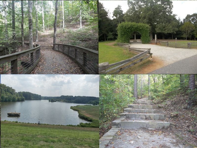
We will start at the parking lot near the intersection of Hog Mountain Rd and Pine Rd. Our pace will be moderate to fast with "water break" at designated points. After brief introductions, we will hike the paved (east side) Miller Lake Trail, then take the East Equestrian Trail and connect halfway through the paved East Meadow Trail. We will then "grasswhack" to continue on the paved trail around the Pond which takes us to the Fence Rd Entrance where we will have our lunch at the Pavilion. At lunch break you will be treated with informative Nutrition Class. We will continue on through the paved West Meadow Trail stopping by the Observation Terrace; and then proceed to the entrance of the Ravine Loop Trail where we can have a short stop for a "photo-op". The Ravine Loop will take us through the Indian Mounds and to the Ravine Cliff where the Table Rock Waterfall is located - hopefully there's plenty of waterflow. We will continue on to Beech Trail that will connect us to the other half of the paved West Meadow Trail and proceed to Carriage Trail. From there we will connect to the West Equestrial Trail and finally completing our hike through the (west side) paved Miller Lake Trail which will take us to the parking lot by 2:30 pm. What I love about this park is that it invigorates our sense of well-being. Gwinnett County's pursuit to protect and preserve vital ecological areas, such as the forest, lakes, ponds, streams and meadows does not only foster a diverse and long-term sustainable ecosystems in the community, but also fosters health and well-being of the people. Little Mulberry Park is equipped with amenities such as a large rustic-looking picnic pavilion, two smaller picnic pavilions, restrooms, a playground, and an observation terrace at the peak of the West Meadow, which is one of the highest elevations in Gwinnett County. | ||||||||||||||
| ||||||||||||||
| How to Get There: | ||||||||||||||
| Event Directions: | From Atlanta take I-85 North Take Exit 120 for Hamilton Mill Rd. | |||||||||||||
| Notes: | ||||||||||||||
* We encourage all members to follow our Etiquette Guidelines while participating in AOC events. | ||||||||||||||
Cancellation/Partial Attendance: Please review the AOC cancellation policy. | ||||||||||||||
 Calendar of Events
 Event Places