 Print-Friendly Version Print-Friendly Version
|
|
Arkaquah Trail to Brasstown Bald - Top & Back | |||||||
| The Basics: | |||||||
| Event Type: | Hike | ||||||
| Event Location: | Near Young Harris GA | ||||||
| Date(s) & Time: | Sat, Dec 1 2012 9:30 am >> Sat, Dec 1 2012 5:00 pm (Carpool Departure: 7:45 am *log in for location*) | ||||||
| Registration Opens: | Sun, Nov 4 2012 8:07 pm | ||||||
| Registration Cut Off: | Fri, Nov 30 2012 2:45 pm | ||||||
| Event Duration: | 7 Hours 30 Minutes | ||||||
| Difficulty Rating: | D5: Difficult | ||||||
| Distance: | 12 Miles | ||||||
| Pace: | Moderate | ||||||
| Trip Leader(s): | Tom Jarosz Email Trip Leader(s) Email Trip Leader(s)
You must be logged in to get the Trip Leader contact information. | ||||||
| Member Cost: | None | ||||||
| Participant Info: | |||||||
| Who's Invited: | Members Only, 21 And Older Only | ||||||
| Maximum Group Size: | 16 | ||||||
| Minimum Group Size: | 4 | ||||||
| Number Registered So Far: | 10 / 0 (To see who's signed up, log in to the Member Area) | ||||||
| Are Dogs Permitted: | Yes | ||||||
| Itinerary: | |||||||
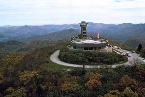
The Arkaquah Trail is widely regarded to be one of the most challenging and scenic in GA. Looking north from the overlooks, you can see Standing Indian Mtn and even parts of the Smokies as well. This is a 12-mile strenuous hike. Do not attempt this hike unless you have successfully completed a long hike in the past with a lot of elevation gain.
| |||||||
| |||||||
| How to Get There: | |||||||
| Event Directions: | Directions to Track Rock Gap (Arkaquah Trailhead): From the Park & Ride we will go north on Georgia 400 to Dahlonega. Continue on US Hwy 19 North past Voget State Park, then take a right on State Road 180 East. Stay on 180 for 2.4 miles, turn left at Town Creek School Rd and after 2 miles turn right on Trackrock Church Rd. Take another right onto Trackrock Gap Rd. The parking lot at the trailhead is on the left. | ||||||
| Carpool to Event Distance (round trip): | 202Mile(s) | ||||||
| Carpool Departure Time: | 7:45 am | ||||||
| Carpool Location: | Log in for location | ||||||
| Carpool Directions: | Log in for directions | ||||||
| Carpool Cost: | Estimated cost per vehicle for this event is $80.80 using a reimbursement rate guideline of $0.400 per mile. The total amount should be divided by the number of people in the vehicle, including the driver. This is a guideline, not a rule, for drivers but the cost should not be higher unless there are extenuating circumstances. | ||||||
| Notes: | |||||||
|
* We encourage all members to follow our Etiquette Guidelines while participating in AOC events. | |||||||
Cancellation/Partial Attendance: Please review the AOC cancellation policy. | |||||||
 Calendar of Events
 Event Places