 Print-Friendly Version Print-Friendly Version
|
|
Backpacking: Rough Ridge & Jacks River (w/ optional hike to Jacks Falls) | |||||||
| The Basics: | |||||||
| Event Type: | Backpacking | ||||||
| Event Location: |
Beautiful Cohutta Wilderness (E. Cowpen to Rough Ridge, Jacks Falls, Jacks River Trail to Dally Gap) | ||||||
| Date(s) & Time: | Sat, Jul 21 2007 8:00 am >> N/A (Carpool Departure: 8:05 am *log in for location*) | ||||||
| Registration Opens: | Mon, Jul 9 2007 12:00 am | ||||||
| Registration Cut Off: | Thu, Jul 19 2007 11:59 pm | ||||||
| Event Duration: | Per Itinerary | ||||||
| Difficulty Rating: | D5: Difficult | ||||||
| Trip Leader(s): | Paula Schubert Email Trip Leader(s) Email Trip Leader(s)
You must be logged in to get the Trip Leader contact information. | ||||||
| Member Cost: | None | ||||||
| Participant Info: | |||||||
| Who's Invited: | Members Only, 21 And Older Only | ||||||
| Maximum Group Size: | 11 | ||||||
| Minimum Group Size: | 3 | ||||||
| Number Registered So Far: | 11 / 0 (To see who's signed up, log in to the Member Area) | ||||||
| Are Dogs Permitted: | No | ||||||
| Itinerary: | |||||||
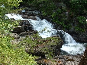
| Let's go backpacking in the beautiful Cohuttas.... This trip will require a car shuttle, but our adventure begins at Three Forks trailhead. We'll be hiking in on E. Cowpen (.4 miles) to the Rough Ridge Trail. Rough Ridge is a 7 mile trail rated moderate to strenuous due to the elevation change, which it loses 2140 ft. from start to finish. This ridge trail descends to a hardwood cove and then around the 4th mile becomes very steep and sometimes rocky as it continues to descend to Rough Creek. Hiking poles/stick are required because of the steep descend and narrowing trail. Once to the end of Rough Ridge, we'll set up camp, relax and enjoy everyone's company. I highly recommend venturing to Jacks Falls. It's optional , but only one river crossing and 1.2 miles downstream (north) from camp. Believe me, it's well worth this short hike along the river and offers a great swimming hole for those wanting to cool off. We'll also have a good spot to cool off and swim near camp too.
Our adventure doesn't stop on Saturday because Sunday we'll pack up and head upstream (south) on the Jacks River trail, where we'll cross Jacks river 19 times. Hiking poles/stick are required for the crossings. The last 2.3 miles after the last river crossing is through a beautiful hardwood forest where our hike ends at Dally Gap. From here, we'll shuttle back to Three forks trailhead for the other vehicles. | |||||||
| |||||||
| How to Get There: | |||||||
| Carpool to Event Distance (round trip): | 180Mile(s) | ||||||
| Carpool Departure Time: | 8:05 am | ||||||
| Carpool Location: | Log in for location | ||||||
| Carpool Directions: | Log in for directions | ||||||
| Carpool Cost: | Estimated cost per vehicle for this event is $72.00 using a reimbursement rate guideline of $0.400 per mile. The total amount should be divided by the number of people in the vehicle, including the driver. This is a guideline, not a rule, for drivers but the cost should not be higher unless there are extenuating circumstances. | ||||||
| Notes: | |||||||
|
Are Dogs Permitted? No, because of river crossings. Will this event occur rain or shine? No, not in severe weather. Please be considerate of others. If you sign-up and cannot attend, please e-mail the event leader so others that may be on a waiting list may attend. E-mail the event leader to be put on a waiting list if the trip is at the max number of attendees. * We encourage all members to follow our Etiquette Guidelines while participating in AOC events. | |||||||
| Cost Includes: | Please share gas expenses with carpool drivers. | ||||||
Cancellation/Partial Attendance: Please review the AOC cancellation policy. | |||||||
 Calendar of Events
 Event Places