 Print-Friendly Version Print-Friendly Version
|
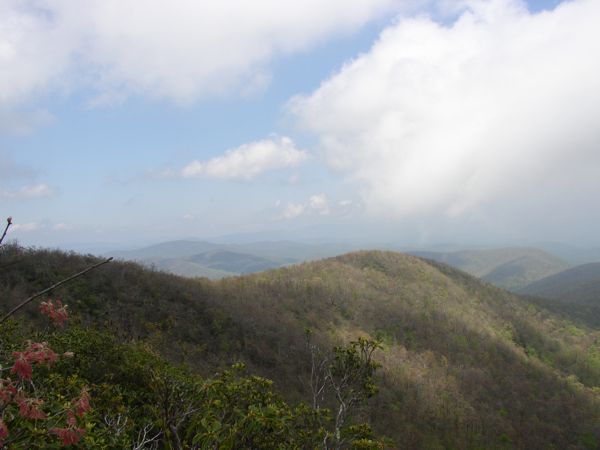
AT - Tray Mountain from Unicoi Gap | |||||||
| The Basics: | |||||||
| Event Type: | Hike | ||||||
| Event Location: |
Unicoi Gap Parking Lot


| ||||||
| Date(s) & Time: | Sat, Jan 12 2013 9:15 am >> Sat, Jan 12 2013 5:00 pm (Carpool Departure: 7:45 am *log in for location*) | ||||||
| Registration Opens: | Thu, Jan 10 2013 7:00 am | ||||||
| Registration Cut Off: | Sat, Jan 12 2013 7:00 am | ||||||
| Event Duration: | 7 Hours 45 Minutes | ||||||
| Difficulty Rating: | D5: Difficult (Exploratory) | ||||||
| Distance: | 10.2 Miles | ||||||
| Pace: | Leisurely | ||||||
| Trip Leader(s): | Rafiq Pavan  Email Trip Leader(s) Email Trip Leader(s)
You must be logged in to get the Trip Leader contact information. | ||||||
| Member Cost: | None | ||||||
| Participant Info: | |||||||
| Who's Invited: | Members Only, 21 And Older Only | ||||||
| Maximum Group Size: | 8 | ||||||
| Minimum Group Size: | 3 | ||||||
| Number Registered So Far: | 10 / 0 (To see who's signed up, log in to the Member Area) | ||||||
| Are Dogs Permitted: | Yes | ||||||
|
Note: This is an "EXPLORATORY" trip. This means that there are parts of this trip, or perhaps the whole trip, that is new to your Trip Leader(s). However, they are confident that this will not be an issue. This note is here so that you can make an informed decision. When a Trip Leader isn't personally familiar with a trip, there is an increased chance of things not going as planned and you need to be prepared. The Trip Leader may have additional details in the itinerary. | |||||||
| Itinerary: | |||||||
Tray Mountain (elev. 4,430) is the second highest point on the Georgia AT, just 31 feet shy of Blood Mountain. Originally called Trail Mountain, some believe it was named that because of the numerous trails leading to the summit that the Cherokees used to climb in order to identify enemy campfires from the top. Tray Mountain's summit offers spectacular 360 degree views of the surrounding Georgia mountains including Yonah, Brasstown, Currahee, and Rabun. From the Unicoi Gap parking lot, we will hike 5.1 miles to the top of Tray Mountain on the AT and then return the same way for a total of 10.2 miles for the day. The total round-trip elevation gain will be around 3,500 feet. This is NOT a beginners hike, so please be sure you are in good physical condition. However, we will not be hiking at a fast or fitness hike pace.
(Promo photo from Dorothea's Tray Mountain AOC event posting and elevation profile from http://www.georgia-atclub.org/) | |||||||
| |||||||
| How to Get There: | |||||||
| Event Directions: | Unicoi Gap Parking Lot GPS Coordinates: | ||||||
| Carpool to Event Distance (round trip): | 138Mile(s) | ||||||
| Carpool Departure Time: | 7:45 am | ||||||
| Carpool Location: | Log in for location | ||||||
| Carpool Directions: | Log in for directions | ||||||
| Carpool Cost: | Estimated cost per vehicle for this event is $55.20 using a reimbursement rate guideline of $0.400 per mile. The total amount should be divided by the number of people in the vehicle, including the driver. This is a guideline, not a rule, for drivers but the cost should not be higher unless there are extenuating circumstances. | ||||||
| Notes: | |||||||
|
* We encourage all members to follow our Etiquette Guidelines while participating in AOC events. | |||||||
Cancellation/Partial Attendance: Please review the AOC cancellation policy. *Note: Will This Event Occur Rain or Shine? Yes | |||||||
 Calendar of Events
 Event Places