 Print-Friendly Version Print-Friendly Version
|
^^ Summit GA’s Highest Peaks: #15 - Big Bald Mountain (4075’) & #17 - Rich Mountain (4040’) ^^ | |||||||
| The Basics: | |||||||
| Event Type: | Hike | ||||||
| Event Location: |
Rich Mountain Wilderness, near Blue Ridge, GA


| ||||||
| Date(s) & Time: | Sat, Mar 9 2013 8:00 am >> Sat, Mar 9 2013 6:00 pm (Carpool Departure: 8:00 am *log in for location*) | ||||||
| Registration Opens: | Mon, Mar 4 2013 8:00 pm | ||||||
| Registration Cut Off: | Fri, Mar 8 2013 4:00 pm | ||||||
| Event Duration: | Per Itinerary | ||||||
| Difficulty Rating: | D5: Difficult (Exploratory) | ||||||
| Distance: | 11 Miles | ||||||
| Pace: | Moderate | ||||||
| Trip Leader(s): | Mark Email Trip Leader(s) Email Trip Leader(s)
You must be logged in to get the Trip Leader contact information. | ||||||
| Member Cost: | None | ||||||
| Participant Info: | |||||||
| Who's Invited: | Members Only, 21 And Older Only | ||||||
| Maximum Group Size: | 12 | ||||||
| Minimum Group Size: | 4 | ||||||
| Number Registered So Far: | 5 / 0 (To see who's signed up, log in to the Member Area) | ||||||
| Are Dogs Permitted: | Yes | ||||||
|
Note: This is an "EXPLORATORY" trip. This means that there are parts of this trip, or perhaps the whole trip, that is new to your Trip Leader(s). However, they are confident that this will not be an issue. This note is here so that you can make an informed decision. When a Trip Leader isn't personally familiar with a trip, there is an increased chance of things not going as planned and you need to be prepared. The Trip Leader may have additional details in the itinerary. | |||||||
| Itinerary: | |||||||
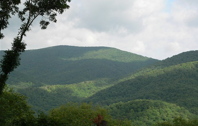
The North Georgia mountains may not be the Himalayas or the Rockies, but do offer many opportunties for challenging and exciting hikes to outstanding scenic views. For this series, we are summiting the 20 highest peaks in Georgia. (For more info on the criteria used, click here.) #15 Big Bald Mountain & #17 Rich Mountain Standing 4075' above sea level with 1755' feet of clean prominence, Big Bald Mtn is the tallest in the Rich Mtn Wilderness and the 15th tallest in GA. Rich Mountain is the 2nd tallest in Rich Mtn Wilderness and has clean prominence of 331'.
We will start the hike at Stanley Gap and follow the very pretty Stanley Creek trail for about a mile before beginning our off-trail adventure. We will hike off-trail about 2.5 miles to the top of Big Bald. After claiming this first peak, we will continue off-trail over the other side of Big Bald, pick up a 4WD road for a very short distance, then head off-trail once again to claim our next summit, Rich Mtn. After heading down to a gap, we will pick up a quasi-trail and generally follow a ridge line across the top of Cold Mtn and then down the other side. We'll pick up a road for a very short distance before heading off on another trail which will eventually rejoin the Stanley Creek Trail, that will take us back to the parking lot. After the hike, we will stop for some well deserved BBQ north of Ellijay. Thanks to Jeff H for provinding insight and information which was very beneficial in route planning. | |||||||
| |||||||
| How to Get There: | |||||||
| Event Directions: | Directions to trailhead will be given at carpool (or via email if "meeting at event"). | ||||||
| Carpool to Event Distance (round trip): | 160Mile(s) | ||||||
| Carpool Departure Time: | 8:00 am | ||||||
| Carpool Location: | Log in for location | ||||||
| Carpool Directions: | Log in for directions | ||||||
| Carpool Cost: | Estimated cost per vehicle for this event is $64.00 using a reimbursement rate guideline of $0.400 per mile. The total amount should be divided by the number of people in the vehicle, including the driver. This is a guideline, not a rule, for drivers but the cost should not be higher unless there are extenuating circumstances. | ||||||
| Notes: | |||||||
|
Up to 3 well behaved dogs will be allowed on this event. However, as this event involves a significant amount of off-trail hiking, it is not practical for dogs to be on a leash. Therefore, dogs should be able to be trusted off-leash if being brought on this hike. * We encourage all members to follow our Etiquette Guidelines while participating in AOC events. | |||||||
| Cost Includes: | NA | ||||||
Cancellation/Partial Attendance: Please review the AOC cancellation policy. *Note: NA | |||||||
 Calendar of Events
 Event Places