 Print-Friendly Version Print-Friendly Version
|
Slow and Steady: Lake Winfield Scott to Blood Mtn & Slaughter Mtn | |||||||
| The Basics: | |||||||
| Event Type: | Hike | ||||||
| Event Location: |
Chattahoochee National Forest near Suches, GA


| ||||||
| Date(s) & Time: | Fri, Feb 1 2013 9:45 am >> Fri, Feb 1 2013 9:00 pm (Carpool Departure: 9:45 am *log in for location*) | ||||||
| Registration Opens: | Tue, Jan 29 2013 7:46 pm | ||||||
| Registration Cut Off: | Fri, Feb 1 2013 7:00 am | ||||||
| Event Duration: | Per Itinerary | ||||||
| Difficulty Rating: | D5: Difficult | ||||||
| Distance: | 8.7 Miles | ||||||
| Pace: | Leisurely | ||||||
| Trip Leader(s): | Tony C Email Trip Leader(s) Email Trip Leader(s)
You must be logged in to get the Trip Leader contact information. | ||||||
| Member Cost: | None | ||||||
| Participant Info: | |||||||
| Who's Invited: | Members Only, 21 And Older Only | ||||||
| Maximum Group Size: | 10 | ||||||
| Minimum Group Size: | 3 | ||||||
| Number Registered So Far: | 5 / 0 (To see who's signed up, log in to the Member Area) | ||||||
| Are Dogs Permitted: | No | ||||||
| Itinerary: | |||||||
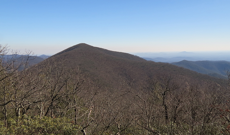
Ok the weather forecast for Fri is looking sunny and COLD. Highs in the 20s in the mtns and wind gusts up to 30mph and wind chill values near 0. So while this is a D4 type of route, the weather on this one is pushing it up to a D5. The plan is to start at Lake Winfield Scott and hike around the lake..enjoying the views of Slaughter Mtn in the distance...that part is just 1 mile and flat. Then we get on the Jarrad Gap trail and climb up to the AT where we take it up to the top of Blood Mtn. I'll probably hike down the other side about 200' or so to enjoy those overlooks but that is optional and you can just hang out at the top if you want. But after a long break up there either way, we will head back down, but hang a left on the Duncan Ridge trail. When we get to the flanks of Slaughter Mtn, we will go off trail for about a third of a mile to the top of Slaughter. I wouldn't really this "bushwhacking" because terrain is open and not like you have to fight through dense vegetation..it is just walking through the woods. We will take a long break at the top of Slaughter and then it's mostly downhill from there...back to the DRT and then out to Wolfpen Gap. We need two cars to do a shuttle. It's only about 3 1/2 miles between shuttle points so we could do it with two full cars but wouldl just take a little extra shuttling back and forth. If we only had one carful, we will have to just head back to Lake Winfield Scott from Slaughter..will be a mile or two longer and maybe push this up to a D5. The total ascent is close to 2400 so would already be pushing a D5 without that but the slow pace should help. And by slow, I mean 1 1/2 to 2 mph starting out with plenty of breaks. You can hike ahead at your own pace on most of the uphills but keep in mind if you do that, if you get to the top 45 min before the tail end of the group, be sure you are fine hanging out there that extra time. Be sure to dress warm so you are comfortable standing around as well as moving. That sounds difficult with this forecast but can be done....and it will be colder on top of Blood Mtn and supposed to be windy with gusts up to 30mph. So wind chill in the single digits. Although you can always get in the AT shelter out of the wind, now that I think of it. But should be a beautiful day to be up in the mtns. I tried to make the carpool after the worst of rush hour because fighting traffic is not a great way to start out. We should have enough daylight ot complete the hike but bring a headlamp or flashlight just in case. I have GPS and map and compass and have hiked all these trails before, so shouldn't be an issue if we barely run out of daylight. (And thanks to Sam L for starting this “Slow and Steady” series, and I hope to lead a few more of these myself for those who enjoy a long hike with a leisurely to moderate pace. These are just an alternative to the faster, "fitness" hikes, which are great too, but not always in the mood for one of those. So we will take our time with this one, esp on the uphill sections.)
| |||||||
| |||||||
| How to Get There: | |||||||
| Event Directions: | Directions to trailhead given at carpool or email if meeting at event. | ||||||
| Carpool to Event Distance (round trip): | 140Mile(s) | ||||||
| Carpool Departure Time: | 9:45 am | ||||||
| Carpool Location: | Log in for location | ||||||
| Carpool Directions: | Log in for directions | ||||||
| Carpool Cost: | Estimated cost per vehicle for this event is $56.00 using a reimbursement rate guideline of $0.400 per mile. The total amount should be divided by the number of people in the vehicle, including the driver. This is a guideline, not a rule, for drivers but the cost should not be higher unless there are extenuating circumstances. | ||||||
| Notes: | |||||||
|
* We encourage all members to follow our Etiquette Guidelines while participating in AOC events. | |||||||
Cancellation/Partial Attendance: Please review the AOC cancellation policy. | |||||||
 Calendar of Events
 Event Places