 Print-Friendly Version Print-Friendly Version
|
|
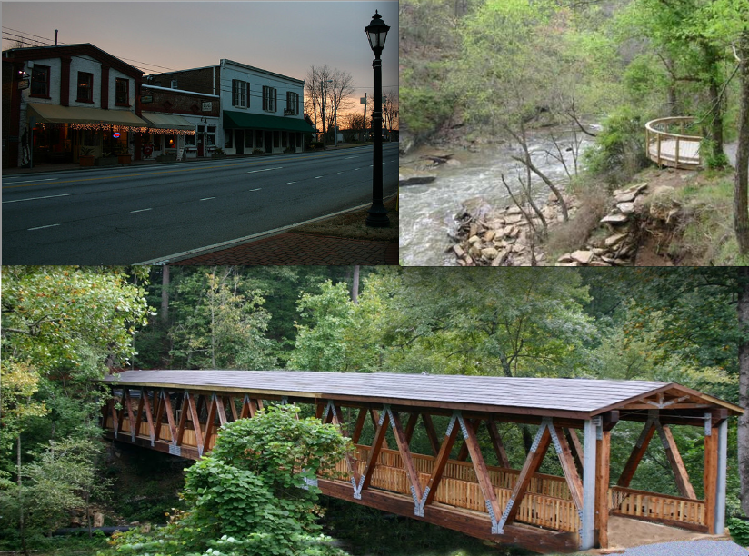
Vickery Creek Easter Weekend Dayhike with our Sierra Club friends! | |||||||
| The Basics: | |||||||
| Event Type: | Hike | ||||||
| Event Location: |
Chattahoochee River Nat'l Rec. Area, Roswell, GA


| ||||||
| Date(s) & Time: | Sat, Mar 30 2013 9:00 am >> Sat, Mar 30 2013 12:30 pm | ||||||
| Registration Opens: | Wed, Mar 20 2013 9:00 pm | ||||||
| Registration Cut Off: | Fri, Mar 29 2013 9:00 pm | ||||||
| Event Duration: | 3 Hours 30 Minutes | ||||||
| Difficulty Rating: | D2: Easy to Moderate | ||||||
| Distance: | 5 Miles | ||||||
| Pace: | Leisurely | ||||||
| Trip Leader(s): | Charlie Cottingham Email Trip Leader(s) Email Trip Leader(s)
You must be logged in to get the Trip Leader contact information. | ||||||
| Member Cost: | None | ||||||
| Participant Info: | |||||||
| Who's Invited: | Members Only, 21 And Older Only | ||||||
| Maximum Group Size: | 12 | ||||||
| Minimum Group Size: | 2 | ||||||
| Number Registered So Far: | 14 / 0 (To see who's signed up, log in to the Member Area) | ||||||
| Are Dogs Permitted: | No | ||||||
| Itinerary: | |||||||
Our friends in the Sierra Club have invited us to join them for a 3-hour dayhike at lovely "Vickery Creek" on the Saturday of Easter Weekend. This popular unit of the Chattahoochee River Nat'l Recreation Area (CRNRA) is conveniently located in Roswell, GA, just 10 miles north of Atlanta. Along the trail we'll have spectacular views of the large rocky creek (a.k.a. "Big Creek") and its waterfalls, rapids and mill ruins - also beautiful wildflowers, trees and wildlife. The Sierra Club's representative for the hike will be Bob Springfield, an experienced Sierra Club volunteer who knows these trails well. I (Charlie) have hiked and "orienteered" often at Vickery Creek and enjoy its variety of trails and scenery. I'll be leading the event for the Atlanta Outdoor Club but Bob will choose our specific route. Thanks to Bob for recently joining the AOC! We'll gather at 9:00 AM in the convenient free parking lot behind "Roswell Mill," a historic area that was built in the 1800s to harness the creek's water power. (See detailed Directions below, plus Lat/Lon and street address for GPS, etc.) The massive covered bridge pictured above crosses the creek just below this lot, allowing easy access to the CRNRA hiking trails. We intend to take a leisurely to moderate pace and stop occasionally along the way to regroup and to observe and photograph the waterfalls, rapids and ruins along the creek; We plan to hike a total of about 5 miles with perhaps 500 vertical feet of total uphill ascending during the 3-hour hike. | |||||||
| |||||||
| How to Get There: | |||||||
| Event Directions: | DIRECTIONS to "ROSWELL MILL" PARKING LOT (VICKERY CREEK COVERED BRIDGE TRAILHEAD) from GA-400/ I-285 INTERCHANGE: GPS & GOOGLE.com/Maps USERS: You can enter as your destination either of the following: Lon/Lat Coordinates: Approx. Street Address: | ||||||
| Notes: | |||||||
|
* We encourage all members to follow our Etiquette Guidelines while participating in AOC events. | |||||||
| Cost Includes: | Free event with Free parking! | ||||||
Cancellation/Partial Attendance: Please review the AOC cancellation policy. | |||||||
 Calendar of Events
 Event Places