 Print-Friendly Version Print-Friendly Version
|
|
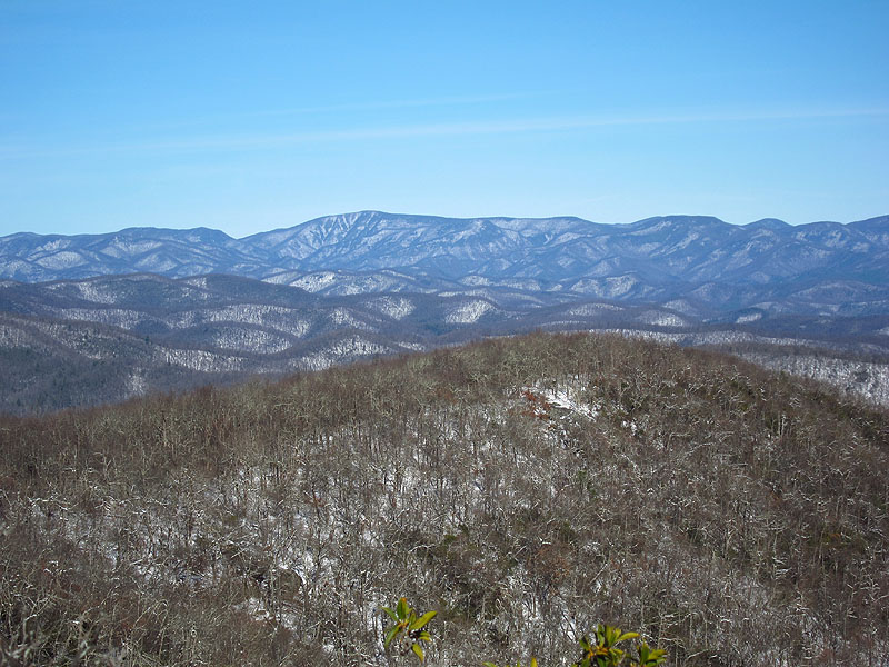
Tray Mountain from Unicoi Gap | |||||||
| The Basics: | |||||||
| Event Type: | Hike | ||||||
| Event Location: |
North of Helen GA


| ||||||
| Date(s) & Time: | Sun, Feb 24 2013 9:00 am >> Sun, Feb 24 2013 7:00 pm (Carpool Departure: 9:00 am *log in for location*) | ||||||
| Registration Opens: | Fri, Feb 22 2013 12:35 pm | ||||||
| Registration Cut Off: | Sat, Feb 23 2013 8:00 pm | ||||||
| Event Duration: | 10 Hours | ||||||
| Difficulty Rating: | D5: Difficult | ||||||
| Distance: | 11 Miles | ||||||
| Pace: | Moderate | ||||||
| Trip Leader(s): | Doug L Email Trip Leader(s) Email Trip Leader(s)
You must be logged in to get the Trip Leader contact information. | ||||||
| Member Cost: | None | ||||||
| Participant Info: | |||||||
| Who's Invited: | Members Only, 21 And Older Only | ||||||
| Maximum Group Size: | 8 | ||||||
| Minimum Group Size: | 2 | ||||||
| Number Registered So Far: | 6 / 0 (To see who's signed up, log in to the Member Area) | ||||||
| Are Dogs Permitted: | No | ||||||
| Itinerary: | |||||||
This hike on the Appalachian Trail will start at Unicoi Gap North of Helen. We will go up Rocky Top Mountain gaining 1100 feet of elevation, go down 800 feet to Indian Grave Gap and then go up 1300 feet to the top of Tray Mountain. We will then follow the trail about .25 miles to a nice overlook where we will have lunch. We return following the same route. At nearly 11 miles and 3200 feet of elevation gain this will be a strenuous hike. The trip up to Tray has 2 uphill sections with about 2400 feet of elevation gain but most people find the 800 foot climb to the top of Rocky Top on the way back the most challenging part of the hike. This hike normally takes about 5 to 6 hours but it could be longer depending on the group. We will be hiking at a moderate pace (by D5 standards). Faster hikers can go ahead but we will regroup at road crossings and the top of Tray Mountain to avoid getting too strung out. The drive is about 1.5 hours each way not counting the usual break on the way up. NOTES: This hike will be cancelled if a steady all day rain is forecast or it looks like there will be ice on the roads. | |||||||
| |||||||
| How to Get There: | |||||||
| Event Directions: | Directions to trailhead will be given at carpool (or via email if "meeting at event"). | ||||||
| Carpool to Event Distance (round trip): | 125Mile(s) | ||||||
| Carpool Departure Time: | 9:00 am | ||||||
| Carpool Location: | Log in for location | ||||||
| Carpool Directions: | Log in for directions | ||||||
| Carpool Cost: | Estimated cost per vehicle for this event is $50.00 using a reimbursement rate guideline of $0.400 per mile. The total amount should be divided by the number of people in the vehicle, including the driver. This is a guideline, not a rule, for drivers but the cost should not be higher unless there are extenuating circumstances. | ||||||
| Notes: | |||||||
|
Because this a D5 event, if you have not very recently completed some tough AOC hikes, I will be contacting you to determine your level of fitness and experience to make sure this is the right hike for you. * We encourage all members to follow our Etiquette Guidelines while participating in AOC events. | |||||||
| Cost Includes: | NA | ||||||
Cancellation/Partial Attendance: Please review the AOC cancellation policy. *Note: NA | |||||||
 Calendar of Events
 Event Places