 Print-Friendly Version Print-Friendly Version
|
|
*You Can Do It* #4 Saturday Morning at Serenbe | |||||||
| The Basics: | |||||||
| Event Type: | Hike | ||||||
| Event Location: |
Chattahoochee Hills, GA


| ||||||
| Date(s) & Time: | Sat, Mar 16 2013 10:30 am >> Sat, Mar 16 2013 1:00 pm | ||||||
| Registration Opens: | Mon, Mar 11 2013 7:00 pm | ||||||
| Registration Cut Off: | Sat, Mar 16 2013 7:00 am | ||||||
| Event Duration: | 2 Hours 30 Minutes | ||||||
| Difficulty Rating: | D2: Easy to Moderate | ||||||
| Distance: | 6 Miles | ||||||
| Pace: | Leisurely | ||||||
| Trip Leader(s): | John Stirman Lemmy  Email Trip Leader(s) Email Trip Leader(s)
You must be logged in to get the Trip Leader contact information. | ||||||
| Member Cost: | None | ||||||
| Participant Info: | |||||||
| Who's Invited: | Members Only, 21 And Older Only | ||||||
| Maximum Group Size: | 14 | ||||||
| Minimum Group Size: | 4 | ||||||
| Number Registered So Far: | 14 / 0 (To see who's signed up, log in to the Member Area) | ||||||
| Are Dogs Permitted: | Yes | ||||||
| Itinerary: | |||||||
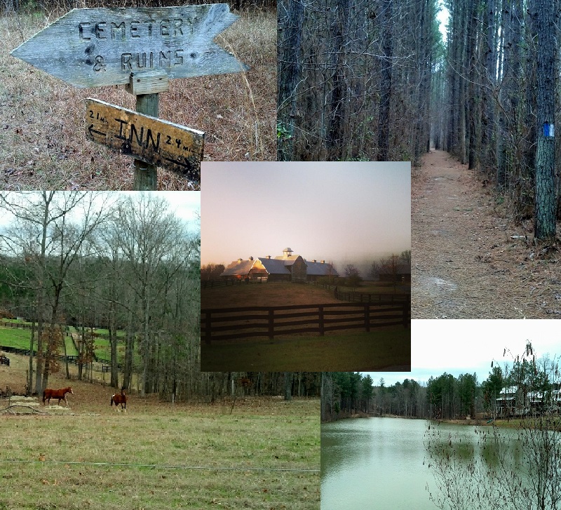
Welcome to #4 of my *You Can Do It* Series of hikes! The *You Can Do It* hikes are designed especially for newer hikers who aren't ready for faster and more strenuous hikes. This time, we’ll be enjoying the wonderful trails of the Serenbe Community. Serenbe is in the heart of the Chattahoochee Hill Country – which is protected with a master plan that calls for 80% green space. This hike will begin at the Farmers Market public parking area in the lovely rural downtown area. However, most of our time will be spent on trails that run alongside Cedar Creek. The paths may take us past beautiful horse pastures, scenic ponds, the Condor family cemetery, and the ruins of their stone dairy barn. Although we'll be hiking approximately 6 miles, we'll be taking this at a leisurely pace with short breaks for pics and to catch our breath. This would be a good hike for beginners who can handle a little bit of distance. Also, we’ll be sticking close together for this hike as there are many cross trails at Serenbe and you could become disoriented. There are two separate hikes with lunch in between. If you are new to hiking, I'd strongly suggest you only sign up for one of the hikes as the combined distance for both is around 12 miles. If you sign up for both hikes, I may contact you to make sure you can handle the extended distance. The (optional) lunch will be in Serenbe at The Blue Eyed Daisy from around 1:00 PM to 2:30 PM. The Blue eyed Daisy is a little local place that has won an episode of (Food Networks) Cupcake Wars and also serves wonderful sandwiches and salads. | |||||||
| |||||||
| How to Get There: | |||||||
| Event Directions: | Directions: 9110 Selborne Ln, Chattahoochee Hills, GA 30268 Located just 32 miles South of Atlanta
From Atlanta and Points North and Airport: • Take I-85 South just past the airport to exit #69 • Take exit #69 and follow the signs for South Fulton Parkway (there are no real turns, lanes just veer off) • Go about 15 miles and turn left onto Cochran Mill Road (first turn once road narrows to two lanes) • Go 2.6 miles until Cochran Mill dead ends into Hutcheson Ferry Road • Turn right onto Hutcheson Ferry Road and go about 2 miles. • Turn left on Atlanta-Newnan Road • Travel approximately 1 mile and turn right on Selborne Lane. Drive straight ahead into the community. Park at the Farmer’s Market Public Parking area on the right, near the middle of town. •When coming from the airport, if there is a choice between I-85 and Spur 14, take Spur 14 to South Fulton Parkway.
From East or West of Atlanta: • Take I-285 to exit #62 and follow the signs for South Fulton Parkway • Now follow the first set of directions above starting with the third (3rd) dot
From the South, traveling North on I-85: • Take I-85 to exit #51 and turn left • Go ½ mile and turn right onto Ga. Highway 29 • Go 5 miles until you come to a stop light in the village of Palmetto • Turn left at the stop light onto Toombs Street • Take Toombs through Palmetto until you come to a flashing light • At this light, turn right onto Hutcheson Ferry Road • Turn left on Atlanta-Newnan Road • Travel approximately 1 mile and turn right on Selborne Lane. Drive straight ahead into the community. Park at the Farmer’s Market Public Parking area on the right, near the middle of town.
From the South, traveling North on I-75: • Take I-285 West • Take I-285 to exit #62 and follow the signs for South Fulton Parkway
| ||||||
| Notes: | |||||||
|
We will allow up to four dogs on this hike. Although they are not allowed in the Blue Eyed Daisy, there are dog posts outside and it is even an option to dine outside on the patio. :-) * We encourage all members to follow our Etiquette Guidelines while participating in AOC events. | |||||||
Cancellation/Partial Attendance: Please review the AOC cancellation policy. | |||||||
 Calendar of Events
 Event Places