 Print-Friendly Version Print-Friendly Version
|
|
Sassafras Mt. to Drawbar Cliffs | |||||||
| The Basics: | |||||||
| Event Type: | Hike | ||||||
| Event Location: |
Pickens, SC


| ||||||
| Date(s) & Time: | Sat, Mar 16 2013 7:30 am >> Sat, Mar 16 2013 6:00 pm (Carpool Departure: 7:30 am *log in for location*) | ||||||
| Registration Opens: | Mon, Mar 11 2013 8:06 pm | ||||||
| Registration Cut Off: | Fri, Mar 15 2013 6:00 pm | ||||||
| Event Duration: | Per itinerary | ||||||
| Difficulty Rating: | D5: Difficult | ||||||
| Distance: | 16 Miles | ||||||
| Pace: | Moderate | ||||||
| Trip Leader(s): | Beth H Email Trip Leader(s) Email Trip Leader(s)
You must be logged in to get the Trip Leader contact information. | ||||||
| Member Cost: | None | ||||||
| Participant Info: | |||||||
| Who's Invited: | Members Only, 21 And Older Only | ||||||
| Maximum Group Size: | 8 | ||||||
| Minimum Group Size: | 4 | ||||||
| Number Registered So Far: | 10 / 0 (To see who's signed up, log in to the Member Area) | ||||||
| Are Dogs Permitted: | Yes | ||||||
| Itinerary: | |||||||
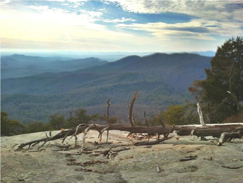
Starting at Chimney Top Gap the trail climbs 1,200 ft. over 2.7 miles to the top of Sassafras Mt. Some of the trees have been thinned along the trail, providing nice mountain views. At 3,554 ft. Sassafras is the highest point in SC, though the border between NC & SC runs along the ridge. We'll stop at the overlook there & then proceed to the trail towards Table Rock. This is a rolling trail with lots of ascents & descents. The trail passes an old home site, through rhododendron arches, over small streams, & through lush forest. About 4.5 miles from Sassafrass Mtn. there is a big boulder field where we can spend some time climbing & exploring. Leaving the boulder field you can sneak a precarious view of a We continue climbing to reach the cliffs & the overlook where we'll have lunch and enjoy the view. Then it's back the way we came. If it's not too late & everyone wants to we can stop for dinner before we hit the GA border. | |||||||
| |||||||
| How to Get There: | |||||||
| Event Directions: | From Indian Trail travel I-85 North approx 78 miles to SC 11 (Exit 1). Go North on SC 11 approx 47 miles to US 178. Turn left on US 178 & drive 7 miles to the town of Rocky Bottom. Turn right on F. Van Clayton Rd. & drive 1.3 miles. Pass the sign for Chimney Top Gap on the left. Go over the hill & the parking area will be on the left. | ||||||
| Carpool to Event Distance (round trip): | 280Mile(s) | ||||||
| Carpool Departure Time: | 7:30 am | ||||||
| Carpool Location: | Log in for location | ||||||
| Carpool Directions: | Log in for directions | ||||||
| Carpool Cost: | Estimated cost per vehicle for this event is $112.00 using a reimbursement rate guideline of $0.400 per mile. The total amount should be divided by the number of people in the vehicle, including the driver. This is a guideline, not a rule, for drivers but the cost should not be higher unless there are extenuating circumstances. | ||||||
| Notes: | |||||||
|
* We encourage all members to follow our Etiquette Guidelines while participating in AOC events. | |||||||
Cancellation/Partial Attendance: Please review the AOC cancellation policy. | |||||||
 Calendar of Events
 Event Places
 The Foothills Trail is a well maintained 77 mile scenic trail which stretches from Table Rock State Park to Oconee State park. This time we'll be hiking 16 miles rountrip from Chimney Top Gap to Drawbar Cliffs.
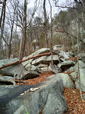 waterfall going over the mountian rock faces.