 Print-Friendly Version Print-Friendly Version
|
|
Jack’s Knob Trail - Brasstown Bald - Chattahoochee Gap | |||||||
| The Basics: | |||||||
| Event Type: | Hike | ||||||
| Event Location: |
Blairsville, GA


| ||||||
| Date(s) & Time: | Sat, Jun 1 2013 8:00 am >> Sat, Jun 1 2013 8:00 pm (Carpool Departure: 8:00 am *log in for location*) | ||||||
| Registration Opens: | Mon, May 27 2013 9:00 pm | ||||||
| Registration Cut Off: | Fri, May 31 2013 6:00 pm | ||||||
| Event Duration: | per itinerary | ||||||
| Difficulty Rating: | D5: Difficult | ||||||
| Distance: | 10 Miles | ||||||
| Pace: | Moderate | ||||||
| Trip Leader(s): | Dorothea Beth H  Email Trip Leader(s) Email Trip Leader(s)
You must be logged in to get the Trip Leader contact information. | ||||||
| Member Cost: | None | ||||||
| Participant Info: | |||||||
| Who's Invited: | Members Only, 21 And Older Only | ||||||
| Maximum Group Size: | 9 | ||||||
| Minimum Group Size: | 2 | ||||||
| Number Registered So Far: | 7 / 0 (To see who's signed up, log in to the Member Area) | ||||||
| Are Dogs Permitted: | No | ||||||
| Itinerary: | |||||||
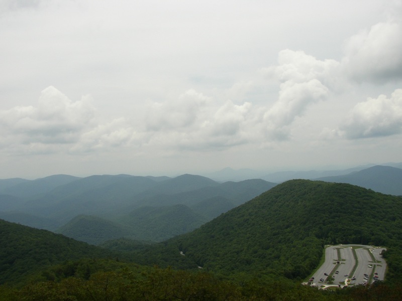
Since the weather for Sunday now looks very bad and the weather for Saturday looks acceptible to good, I have moved the hike forward to Saturday in preference to cancelling it altogether. This hike starts with a steep one-and-a-half-hour climb, comparable to hiking from Unicoi Gap to the top of Rocky and then half again. But the climb is richly rewarded with a 360 degree view from the highest peak in GA. We'll stay at least an hour to have a good look and lunch. Then it is back to the cars and across Hwy 180 to hike the second part of Jack's Knob Trail. At the cars you can pick up another bottle of water, if you wish. Now we hike up and down and up and down again to reach Chattahoochie Gap. A short side trail takes us to the headwaters of the "mighty" Chattahoochie River, which flows to Atlanta and thence to the Gulf of Mexico. Then up and down and up and down again to return to the cars. Technical description: We start at Jack's Gap on Hwy 180 and hike to Brasstown Bald parking lot, gaining 1500 ft of elevation in 2.2 miles. From there we take the Summit Trail to the top, which adds another 500 ft of elevation gain in .6 mile. The return to Jack's Gap is mainly downhill but does involve another 200 ft in elevation gain, leading to a total of 2200 ft of elevation gain over 5.6 miles. Starting again at Jack's Gap and going the opposite direction, we cross Hwy 180 and hike to Chattahoochee Gap. To the gap and back entails a total of 1600 ft elevation gain (1000 ft out and 600 ft back) over 4.6 miles. Hiking the entire trail both ways involves 10.2 miles and 3800 ft elevation gain. If we start hiking at about 10:00, we should finish by no later than 5:00. We'll make a dinner stop at the Nacoochee Tavern in Helen, and we should be back in Atlanta by 8:00-8:30. Anyone needing to return to Atlanta directly after the hike should probably drive separately or arrange to carpool with other hikers who cannot stay for dinner. There can't be many hikes in Georgia or south North Carolina where one doesn't see Brasstown Bald at some point, but surprisingly, I do not have a photo of it. The best I have shows the parking lot that we will be crossing. Beth will be coordinating the carpool at the park-and-ride. I'll join the group at the Cleveland Ingles. | |||||||
| |||||||
| How to Get There: | |||||||
| Event Directions: | From Indian Trail Park & Ride to Cleveland (60 miles): Take 85N, then 985N, then just before Gainesville take 129/11N. Stay on that road to Cleveland and drive right through the town to the intersection with 75 (going to Helen). The Ingles is at the NE corner of the intersection. Dorothea will be waiting behind the gas pumps. There are restrooms and a Starbucks in the Ingles store for those wishing to make a pit stop. From Ingles we take 75, detouring around Helen via Asbestos Rd, drive up the mountain past Unicoi Gap and down the other side to where the road begins to level off; turn left on 180 and continue for about 10 minutes to Jacks Gap parking area. Travel time: 1 hour to Cleveland plus 45 minutes to Jack’s Gap. | ||||||
| Carpool to Event Distance (round trip): | 175Mile(s) | ||||||
| Carpool Departure Time: | 8:00 am | ||||||
| Carpool Location: | Log in for location | ||||||
| Carpool Directions: | Log in for directions | ||||||
| Carpool Cost: | Estimated cost per vehicle for this event is $70.00 using a reimbursement rate guideline of $0.400 per mile. The total amount should be divided by the number of people in the vehicle, including the driver. This is a guideline, not a rule, for drivers but the cost should not be higher unless there are extenuating circumstances. | ||||||
| Notes: | |||||||
|
I will be contacting anyone who has not done at least a D4 hike with the AOC to determine whether this is an appropriate hike for you. * We encourage all members to follow our Etiquette Guidelines while participating in AOC events. | |||||||
Cancellation/Partial Attendance: Please review the AOC cancellation policy. | |||||||
 Calendar of Events
 Event Places