 Print-Friendly Version Print-Friendly Version
|
|
Get to Know East Palisades | |||||||
| The Basics: | |||||||
| Event Type: | Hike | ||||||
| Event Location: |
Atlanta, GA


| ||||||
| Date(s) & Time: | Sat, Jun 1 2013 9:00 am >> Sat, Jun 1 2013 12:00 pm | ||||||
| Registration Opens: | Wed, May 29 2013 8:30 pm | ||||||
| Registration Cut Off: | Sat, Jun 1 2013 7:00 am | ||||||
| Event Duration: | 3 Hours | ||||||
| Difficulty Rating: | D4: Moderate to Difficult | ||||||
| Distance: | 7.5 Miles | ||||||
| Pace: | Fast | ||||||
| Trip Leader(s): | Eric P Email Trip Leader(s) Email Trip Leader(s)
You must be logged in to get the Trip Leader contact information. | ||||||
| Member Cost: | None | ||||||
| Participant Info: | |||||||
| Who's Invited: | Members Only, 21 And Older Only | ||||||
| Maximum Group Size: | 8 | ||||||
| Minimum Group Size: | 2 | ||||||
| Number Registered So Far: | 5 / 0 (To see who's signed up, log in to the Member Area) | ||||||
| Are Dogs Permitted: | No | ||||||
| Itinerary: | |||||||
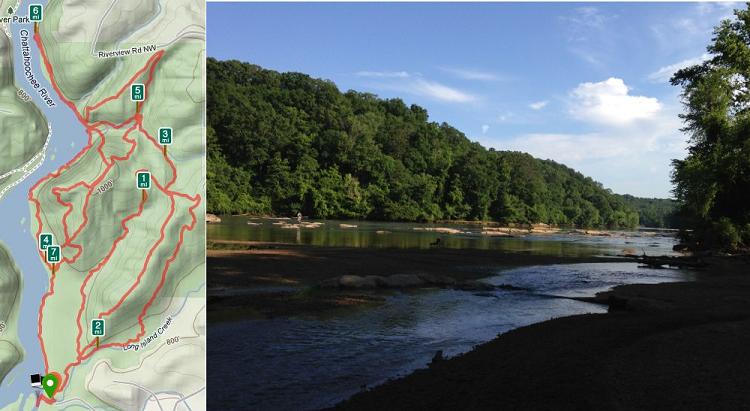
Have you ever wanted to check out all of East Palisades? Well then this is the perfect opportunity. We will be meeting at the Whitewater Creek entrance of East Palisades and then will be hitting almost every main official and unofficial trail through the park. This is a very difficult event at 7.5 miles and roughly 1300 ft of elevation gain and is not recommended for beginners. The hike will be fairly fast paced but not a fitness hike as we make our way around hitting all the best parts of the park such as the bamboo forest, cliffs,"cave", and riverside. We will generally be keeping a pace between 3 and 3.5 miles per hour everywhere other than in the technical section along the river and during brief stops at points of interest. You should be aware that the cliff section along the river includes doing some easy scrambling and walking on narrow ledges. This is probably not advisable to anyone that is truly afraid of heights. In general we will try to stay along the riverside but in places it will be necessary to go up the cliffs which may include the need to pull yourself up steep sections holding onto rocks or trees. Additionally be aware that your feet may get wet in this section depending on the route we choose to take and the water level. The pace in this section will be greatly reduced so that we can carefully make our way through some very technical terrain. | |||||||
| |||||||
| How to Get There: | |||||||
| Event Directions: | Directions from: From eastbound Interstate 285 From westbound Interstate 285 From northbound Interstate 75 From northbound U.S. 41 From southbound U.S. 41 | ||||||
| Notes: | |||||||
|
* We encourage all members to follow our Etiquette Guidelines while participating in AOC events. | |||||||
Cancellation/Partial Attendance: Please review the AOC cancellation policy. | |||||||
 Calendar of Events
 Event Places