 Print-Friendly Version Print-Friendly Version
|
|
Ready for a Challenge? Rocky and Tray in the Same Day | |||||||
| The Basics: | |||||||
| Event Type: | Hike | ||||||
| Event Location: |
Unicoi Gap near Helen GA


| ||||||
| Date(s) & Time: | Sun, Jun 30 2013 9:15 am >> Sun, Jun 30 2013 5:00 pm (Carpool Departure: 7:30 am *log in for location*) | ||||||
| Registration Opens: | Thu, Jun 13 2013 9:00 pm | ||||||
| Registration Cut Off: | Sat, Jun 29 2013 6:00 pm | ||||||
| Event Duration: | Per Itinerary | ||||||
| Difficulty Rating: | D5: Difficult | ||||||
| Distance: | 11 Miles | ||||||
| Pace: | Moderate | ||||||
| Trip Leader(s): | Andrea Nunn Chris H  Email Trip Leader(s) Email Trip Leader(s)
You must be logged in to get the Trip Leader contact information. | ||||||
| Member Cost: | None | ||||||
| Participant Info: | |||||||
| Who's Invited: | Members Only, 21 And Older Only | ||||||
| Maximum Group Size: | 12 | ||||||
| Minimum Group Size: | 4 | ||||||
| Number Registered So Far: | 11 / 0 (To see who's signed up, log in to the Member Area) | ||||||
| Are Dogs Permitted: | Yes | ||||||
| Itinerary: | |||||||
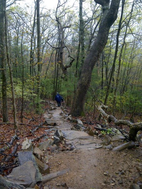
Tray Mountain, with an elevation of 4,430 ft, is the seventh highest peak in Georgia and is within the borders of the Chattahoochee National Forest. The mountain is referred to by some as the grandstand for viewing the Nantahala Mountains in North Carolina and the rest of the Blue Ridge Mountains in Georgia. We will begin our hike at 9:15 am at Unicoi Gap, which is north of Helen, GA. We will ascend 1,125 feet to the top of Rocky Mountain, descend 975 feet to Indian Grave Gap, and then ascend 1,400 feet to the top of Tray Mountain, where we will stop for a 30-minute lunch and take a detour to one of the best overlooks in Georgia. We will then descend Tray and ascend Rocky Mountain again. We should return to the carpool location no later than 5:00 pm. NOTE: This event is intended for people who have recent D5 hiking experience. For beginner hikers, unless you have completed a half marathon, this is NOT the hike for you.
| |||||||
| |||||||
| How to Get There: | |||||||
| Event Directions: | North on GA 400 from the park and ride. When GA 400 ends at Chevron station. continue on GA 115. Go 4.8 miles where GA 115 meets GA 52. Turn right. Continue on GA 115 for 12.5 miles and turn left on Wilford Ash Parkway. After 0.4 miles, Wilford Ash Parkway becomes GA-75. Stay on GA-75 thru Helen. From Helen it is about six miles to Unicoi Gap, where you will see hiker crossing signs. This means the AT is coming up. You will see the parking lot on the right. If you start going much downhill, you have gone too far. On the way back, you do not want to go thru Helen due to the congestion. Before Helen take a right on Alt-75 and follow that to US 129. Take a left there and follow that back to Wilford Ash Parkway and take a right. This takes you to GA-115 where you take another right. From there, you can follow the way you came back to Alpharetta. | ||||||
| Carpool to Event Distance (round trip): | 140Mile(s) | ||||||
| Carpool Departure Time: | 7:30 am | ||||||
| Carpool Location: | Log in for location | ||||||
| Carpool Directions: | Log in for directions | ||||||
| Carpool Cost: | Estimated cost per vehicle for this event is $56.00 using a reimbursement rate guideline of $0.400 per mile. The total amount should be divided by the number of people in the vehicle, including the driver. This is a guideline, not a rule, for drivers but the cost should not be higher unless there are extenuating circumstances. | ||||||
| Notes: | |||||||
|
Rain or shine unless thunderstorms. * We encourage all members to follow our Etiquette Guidelines while participating in AOC events. | |||||||
Cancellation/Partial Attendance: Please review the AOC cancellation policy. *Note: Late cancellations, particularly within 24 hours of the event make it difficult for those on the wait list to attend. Please be courteous to your fellow AOC members and cancel with as much notice as possible. | |||||||
 Calendar of Events
 Event Places