 Print-Friendly Version Print-Friendly Version
|
|
Last Minute Hiking! - Desoto Scout Trail + Desoto Falls + Little River Falls | |||||||
| The Basics: | |||||||
| Event Type: | Hike | ||||||
| Event Location: |
Fort Payne, AL 35967-8016


| ||||||
| Date(s) & Time: | Sun, Jul 28 2013 9:00 am >> Sun, Jul 28 2013 6:00 pm (Carpool Departure: 7:00 am *log in for location*) | ||||||
| Registration Opens: | Fri, Jul 26 2013 3:00 pm | ||||||
| Registration Cut Off: | Sat, Jul 27 2013 8:00 pm | ||||||
| Event Duration: | 9 Hours | ||||||
| Difficulty Rating: | D4: Moderate to Difficult (Exploratory) | ||||||
| Distance: | 9.2 Miles | ||||||
| Pace: | Moderate | ||||||
| Trip Leader(s): | John L Amy  Email Trip Leader(s) Email Trip Leader(s)
You must be logged in to get the Trip Leader contact information. | ||||||
| Member Cost: | None | ||||||
| Participant Info: | |||||||
| Who's Invited: | Members Only, 21 And Older Only | ||||||
| Maximum Group Size: | 12 | ||||||
| Minimum Group Size: | 3 | ||||||
| Number Registered So Far: | 3 / 0 (To see who's signed up, log in to the Member Area) | ||||||
| Are Dogs Permitted: | No | ||||||
|
Note: This is an "EXPLORATORY" trip. This means that there are parts of this trip, or perhaps the whole trip, that is new to your Trip Leader(s). However, they are confident that this will not be an issue. This note is here so that you can make an informed decision. When a Trip Leader isn't personally familiar with a trip, there is an increased chance of things not going as planned and you need to be prepared. The Trip Leader may have additional details in the itinerary. | |||||||
| Itinerary: | |||||||
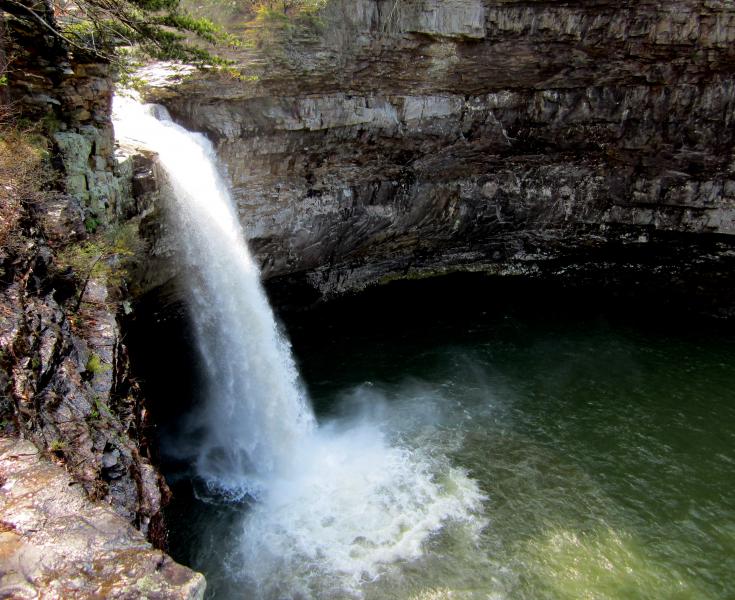
This is an exploratory hike for me since I've never been on the Desoto Scout Trail, although I have been to Desoto Falls. If you Google the Desoto Scout Trail, many sites still list the distance as 4.6 miles (it's an out and back, so a total of 9.2 miles). However, recent work and revitalization has made it a 16-mile scenic trail that follows the West Fork of Little River. The DST starts at Comer Scout Reservation in the North, goes through DeSoto State Park and into Little River Canyon National Preserve, where the majority of the trail is located. It traverses a varied terrain of ridges, valleys, fern glades, rock formations, waterfalls, beside deep pools, riffles, through rhododendron tunnels, creek crossings, swimming holes, and sandy stretches. The DST is moderately difficult. I'd like to hike at least 9 miles. From the reports I've read, it is rocky in places and appropriate footwear is recommended. Due to all the rain we've had, it might be a good idea to bring either waterproof shoes or some solid hiking sandals in case there are water crossings. We will go as far as we can. If the group wants to move farther and we are hiking at a good pace, we'll get in some bonus miles. If time permits and if everyone wants to, we can grab dinner in the Ft. Payne area or maybe Rome, which has a lot of options. Previous and recent D4 hiking experience is mandatory. | |||||||
| |||||||
| How to Get There: | |||||||
| Event Directions: | From Kennesaw the Park n Ride: Take I-75 N for 34.4 mi Continue to end of road near cabin 19 for the trailhead. | ||||||
| Carpool to Event Distance (round trip): | 180Mile(s) | ||||||
| Carpool Departure Time: | 7:00 am | ||||||
| Carpool Location: | Log in for location | ||||||
| Carpool Directions: | Log in for directions | ||||||
| Carpool Cost: | Estimated cost per vehicle for this event is $72.00 using a reimbursement rate guideline of $0.400 per mile. The total amount should be divided by the number of people in the vehicle, including the driver. This is a guideline, not a rule, for drivers but the cost should not be higher unless there are extenuating circumstances. | ||||||
| Notes: | |||||||
|
* We encourage all members to follow our Etiquette Guidelines while participating in AOC events. | |||||||
Cancellation/Partial Attendance: Please review the AOC cancellation policy. | |||||||
 Calendar of Events
 Event Places