 Print-Friendly Version Print-Friendly Version
|
|
Walls of Jericho (An AOC First!) | |||||||
| The Basics: | |||||||
| Event Type: | Hike | ||||||
| Event Location: |
Jackson County, Alabama and Tennessee


| ||||||
| Date(s) & Time: | Sat, Aug 10 2013 10:30 am >> Sat, Aug 10 2013 7:30 pm (Carpool Departure: 7:30 am *log in for location*) | ||||||
| Registration Opens: | Thu, Aug 1 2013 9:00 pm | ||||||
| Registration Cut Off: | Fri, Aug 9 2013 12:00 pm | ||||||
| Event Duration: | 12 Hours (6 hours hiking, 6 hours driving) | ||||||
| Difficulty Rating: | D4: Moderate to Difficult (Exploratory) | ||||||
| Distance: | 11 Miles | ||||||
| Pace: | Moderate | ||||||
| Trip Leader(s): | John L Amy  Email Trip Leader(s) Email Trip Leader(s)
You must be logged in to get the Trip Leader contact information. | ||||||
| Member Cost: | None | ||||||
| Participant Info: | |||||||
| Who's Invited: | Members Only, 21 And Older Only | ||||||
| Maximum Group Size: | 14 | ||||||
| Minimum Group Size: | 4 | ||||||
| Number Registered So Far: | 10 / 0 (To see who's signed up, log in to the Member Area) | ||||||
| Are Dogs Permitted: | Yes | ||||||
|
Note: This is an "EXPLORATORY" trip. This means that there are parts of this trip, or perhaps the whole trip, that is new to your Trip Leader(s). However, they are confident that this will not be an issue. This note is here so that you can make an informed decision. When a Trip Leader isn't personally familiar with a trip, there is an increased chance of things not going as planned and you need to be prepared. The Trip Leader may have additional details in the itinerary. | |||||||
| Itinerary: | |||||||
Note: this event has been edited from it's previous posting as a D3. Additional mileage and ascent was added to visit other attractions resulting in a change of difficulty. Please note, we have never done this hike. It's only rated as a D3 hike, but it is very steep with almost 1100 feet of descent and ascent over a short distance. It's a borderline D3-D4 hike. Please do not sign up if you do not have recent D3 experience or if steep elevation changes are a challenge for you. ** About the Walls of Jericho ** The gorge is just one piece of The Walls of Jericho tract, which was purchased by the State of Alabama’s Forever Wild Land Trust, with the help of The Nature Conservancy in 2004, as part of its mandate to acquire land for public use. The entire tract of land is comprised of 21,453 acres- 12,510 acres inAlabama and 8,943 acres in Tennessee. The only public access to the land is in Jackson County, Alabama. The property adjoins the Skyline Wildlife Management Area. A 100-mile trail system is presently in the planning stages, expanding future opportunities to enjoy the tract's many features.
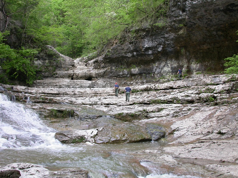
** Hike Details ** This is a shuttle hike, which means we start at one trailhead and end up at another. The 2 trailheads are less than 3 miles apart. After passing a field clearing (a popular campsite area for overnighters) the trail continues on the south side of Turkey Creek on an often muddy and slippery path. At mile 3.7, we'll reach the Walls of Jericho natural amphitheater, take a break and have lunch. Feel free to take a swim if the water is suited for it. We will relax and wander around the amphitheater and neighboring falls. After enjoying the sights and sounds, we will return to the Mill Creek log bridge and begin the 1,000+ foot difficult ascent through rock outcroppings up to the Alabama trailhead. On the way back, we can go back the way we came, or alternatively head to Chattanooga for a relaxing dinner. ** Note about Dogs ** | |||||||
| |||||||
| How to Get There: | |||||||
| Event Directions: | From the Chastain Road Park n Ride: ** Note, Google Maps prefers to send you through Chattanooga (few minutes faster but longer). We are going through Adairsville and Summersville which is over 30 miles shorter. After the hike, we might follow Google Maps on the trip home if we stop for dinner in Chattanooga, hence the total mileage reflects that. ** Take I-75 North to exit 306 for GA-140 W | ||||||
| Carpool to Event Distance (round trip): | 315Mile(s) | ||||||
| Carpool Departure Time: | 7:30 am | ||||||
| Carpool Location: | Log in for location | ||||||
| Carpool Directions: | Log in for directions | ||||||
| Carpool Cost: | Estimated cost per vehicle for this event is $126.00 using a reimbursement rate guideline of $0.400 per mile. The total amount should be divided by the number of people in the vehicle, including the driver. This is a guideline, not a rule, for drivers but the cost should not be higher unless there are extenuating circumstances. | ||||||
| Notes: | |||||||
|
* We encourage all members to follow our Etiquette Guidelines while participating in AOC events. | |||||||
Cancellation/Partial Attendance: Please review the AOC cancellation policy. | |||||||
 Calendar of Events
 Event Places