 Print-Friendly Version Print-Friendly Version
|
|
Wayah Bald NC via Appalachian Trail | |||||||
| The Basics: | |||||||
| Event Type: | Hike | ||||||
| Event Location: | Wayah Gap, near Franklin, NC | ||||||
| Date(s) & Time: | Sat, Jan 5 2008 10:45 am >> N/A (Carpool Departure: 8:15 am *log in for location*) | ||||||
| Registration Opens: | Wed, Dec 19 2007 12:00 am | ||||||
| Registration Cut Off: | Fri, Jan 4 2008 11:59 pm | ||||||
| Event Duration: | ten hours, total hiking and drive time | ||||||
| Difficulty Rating: | D4: Moderate to Difficult | ||||||
| Trip Leader(s): | John Weatherman Gary Babiarz  Email Trip Leader(s) Email Trip Leader(s)
You must be logged in to get the Trip Leader contact information. | ||||||
| Member Cost: | None | ||||||
| Participant Info: | |||||||
| Who's Invited: | Members Only, 21 And Older Only | ||||||
| Maximum Group Size: | 30 | ||||||
| Minimum Group Size: | 4 | ||||||
| Number Registered So Far: | 26 / 0 (To see who's signed up, log in to the Member Area) | ||||||
| Are Dogs Permitted: | Yes | ||||||
| Itinerary: | |||||||
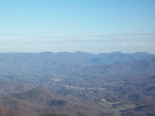
This is an in and out hike, for nine miles total, with about 1500 feet in elevation gain. We will go at a moderate, deliberate pace. If you have resolved to do more hiking in 2008, this is one of your first chances. This hike on the Appalachian Trail in North Carolina involves high elevation and features some outstanding winter views. This is one of the most beautiful sections of the trail in southern North Carolina. The drive from the park-and-ride to the trailhead is just over two hours. This is a two bald hike, including Wine Spring Bald, and our destination, Wayah Bald. At Wayah Bald we will have a 360 degree view of the North Carolina mountains, including the Great Smokey Mountains. We will visit a two-story stone tower built by the Civilian Conservation Corps there in the 30’s. The top of the tower has labeled etchings of the horizon that will show us the names of the mountains we are seeing. Winter offers us the chance for crisp and clear long distance views. The picture above is the view from the Wayah tower towards Franklin. As far as the hike itself, we will start at Wayah Gap at 4200 feet, and go about two and a half miles to the top of Wine Spring Bald at 5300 feet. Then we lose and gain about 400 feet over two more miles to Wayah Bald, also at around 5300 feet. Then we turn around and come back. For those of you who have been to Siler Bald, this is a similar hike to that one, with a similar, if not better, view. In fact, Wine Spring Bald is the mountain with all the antennas on it that you see from Siler. In case you are wondering what balds are, they are a feature unique to the Southern Appalachians. The early settlers found the mountaintops here free of trees and called them balds. To this day there is still no definitive explanation for this, and we don’t intend to come up with one. We are just going to hike. Please join us. | |||||||
| |||||||
| How to Get There: | |||||||
| Event Directions: | From the Indian Trail park and ride, take I-85 North. After 11 miles bear
left to take I-985 North. This road will change to GA 365, US 441, and US
23. Stay on it for 96 miles all the way to Franklin NC. (However, we will make the traditional pit stop at the Burger King in Clayton GA at 75 miles. Burger King will be on the right. From there it is 21 miles to Franklin.) Once outside of Franklin, make a left onto US 64 West. Go 3.7 miles on US 64 and make a right onto Patton Road, then an immediate left onto Wayah Road. (There should be signs for Wayah Bald.) From there it is 8.9 miles to the Appalachian Trail. All of it is paved. Look for the hikers crossing sign at the top of Wayah Gap and there will be a small parking lot on the left. | ||||||
| Carpool to Event Distance (round trip): | 242Mile(s) | ||||||
| Carpool Departure Time: | 8:15 am | ||||||
| Carpool Location: | Log in for location | ||||||
| Carpool Directions: | Log in for directions | ||||||
| Carpool Cost: | Estimated cost per vehicle for this event is $96.80 using a reimbursement rate guideline of $0.400 per mile. The total amount should be divided by the number of people in the vehicle, including the driver. This is a guideline, not a rule, for drivers but the cost should not be higher unless there are extenuating circumstances. | ||||||
| Notes: | |||||||
|
* We encourage all members to follow our Etiquette Guidelines while participating in AOC events. | |||||||
Cancellation/Partial Attendance: Please review the AOC cancellation policy. | |||||||
 Calendar of Events
 Event Places