 Print-Friendly Version Print-Friendly Version
|
|
Exploring Laurel Snow Pocket Wilderness | |||||||
| The Basics: | |||||||
| Event Type: | Hike | ||||||
| Event Location: |
Dayton, TN


| ||||||
| Date(s) & Time: | Sat, Sep 7 2013 7:30 am >> Sat, Sep 7 2013 8:00 pm (Carpool Departure: 7:30 am *log in for location*) | ||||||
| Registration Opens: | Sun, Sep 1 2013 8:20 pm | ||||||
| Registration Cut Off: | Fri, Sep 6 2013 4:00 pm | ||||||
| Event Duration: | Per Itinerary | ||||||
| Difficulty Rating: | D4: Moderate to Difficult | ||||||
| Distance: | 12 Miles | ||||||
| Pace: | Moderate | ||||||
| Trip Leader(s): | Beth H Melanie Marks  Email Trip Leader(s) Email Trip Leader(s)
You must be logged in to get the Trip Leader contact information. | ||||||
| Member Cost: | None | ||||||
| Participant Info: | |||||||
| Who's Invited: | Members Only, 21 And Older Only | ||||||
| Maximum Group Size: | 12 | ||||||
| Minimum Group Size: | 4 | ||||||
| Number Registered So Far: | 9 / 0 (To see who's signed up, log in to the Member Area) | ||||||
| Are Dogs Permitted: | Yes | ||||||
| Itinerary: | |||||||
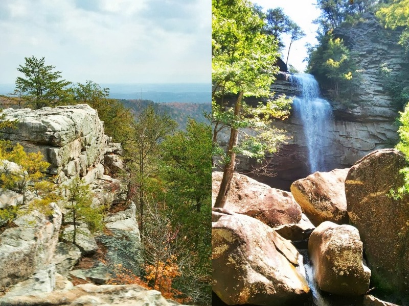
Back on the trail, a 150 ft bridge takes us over Richland Creek, where we will climb up the other side of the gorge to Buzzard Point. If you are really adventurous you can climb the chimneys or just enjoy the view from several overlooks. True to the name, there usually are birds circling above your head. Traveling down a flat trail takes us to Morgan Creek. You have to cross the creek to get to the top of Snow Falls. You will get wet. If you don't bring water shoes you will need to go across barefoot. The water is usually ankle deep. You can climb some roots down to the bottom of falls & walk under it or explore along the top. Some of this trail is not well marked, so be prepared for a little "Trail Hunting" in places. This is going to be a long day because we are going to spend time exploring at all 3 stops. We will stop somewhere in Dayton or outside Chattanooga for dinner before getting back to Atlanta. Dogs are welcome, but be advised there are usually rangers in this wilderness area & they are strict about leashes. | |||||||
| |||||||
| How to Get There: | |||||||
| Event Directions: | I-75 North for 85 miles Merge onto I-24 West toward Chattanooga After 6.2 miles & take the right fork to exit onto US-27 North Travel 41 miles & turn left onto Walnut Grove Rd. Between the Rite Aid & Walgreens. Drive 1.4 miles until you see a white church on the left & the sign for Laurel Snow Pocket Wilderness on the Right. Turn Right onto the gravel Rd & travel .9 miles to the parking lot. | ||||||
| Carpool to Event Distance (round trip): | 269Mile(s) | ||||||
| Carpool Departure Time: | 7:30 am | ||||||
| Carpool Location: | Log in for location | ||||||
| Carpool Directions: | Log in for directions | ||||||
| Carpool Cost: | Estimated cost per vehicle for this event is $107.60 using a reimbursement rate guideline of $0.400 per mile. The total amount should be divided by the number of people in the vehicle, including the driver. This is a guideline, not a rule, for drivers but the cost should not be higher unless there are extenuating circumstances. | ||||||
| Notes: | |||||||
|
This event will be rescheduled in the event of rain. * We encourage all members to follow our Etiquette Guidelines while participating in AOC events. | |||||||
Cancellation/Partial Attendance: Please review the AOC cancellation policy. | |||||||
 Calendar of Events
 Event Places
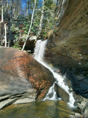 Join me at one of my favorite places to spend the day. The trail starts with a beautiful walk along scenic, boulder-strewn Richland Creek. Climbing out of the gorge, it's on to Laurel Falls. You can navigate the boulders to the base of the falls or just sit on rock & enjoy it from a slight distance.