 Print-Friendly Version Print-Friendly Version
|
|
Cumblerland Trail - Signal Point, Edwards Point and Mushroom Rock | |||||||
| The Basics: | |||||||
| Event Type: | Hike | ||||||
| Event Location: |
Signal Mountain, TN


| ||||||
| Date(s) & Time: | Sun, Oct 27 2013 10:00 am >> Sun, Oct 27 2013 6:00 pm (Carpool Departure: 7:45 am *log in for location*) | ||||||
| Registration Opens: | Thu, Oct 10 2013 8:00 pm | ||||||
| Registration Cut Off: | Sat, Oct 26 2013 8:00 pm | ||||||
| Event Duration: | 8 Hours | ||||||
| Difficulty Rating: | D5: Difficult (Exploratory) | ||||||
| Distance: | 14 Miles | ||||||
| Pace: | Moderate | ||||||
| Trip Leader(s): | Chris L John Christopher  Email Trip Leader(s) Email Trip Leader(s)
You must be logged in to get the Trip Leader contact information. | ||||||
| Member Cost: | None | ||||||
| Participant Info: | |||||||
| Who's Invited: | Members Only, 21 And Older Only | ||||||
| Maximum Group Size: | 14 | ||||||
| Minimum Group Size: | 4 | ||||||
| Number Registered So Far: | 12 / 0 (To see who's signed up, log in to the Member Area) | ||||||
| Are Dogs Permitted: | Yes | ||||||
|
Note: This is an "EXPLORATORY" trip. This means that there are parts of this trip, or perhaps the whole trip, that is new to your Trip Leader(s). However, they are confident that this will not be an issue. This note is here so that you can make an informed decision. When a Trip Leader isn't personally familiar with a trip, there is an increased chance of things not going as planned and you need to be prepared. The Trip Leader may have additional details in the itinerary. | |||||||
| Itinerary: | |||||||
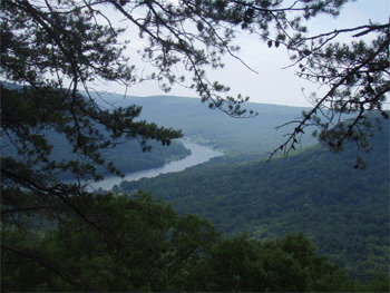
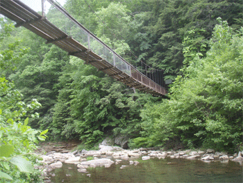
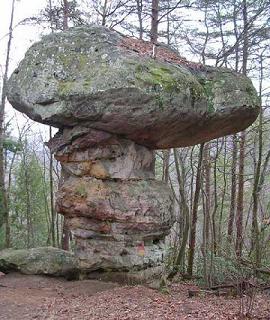
This is an out and back hike mainly along the top of the gorge above the Tennessee River. The strenuous sections are short, but there are several miles of rocky footing along the sides of some of the branch gorges. We will have several spots with outstanding views of the gorges, the Tennessee River and Chattanooga. We also have some rock formations, nice streams and waterfalls, and a couple of swinging bridges. We start at Signal Point, at the beginning of the Cumberland Trail (which stretches north-south across east Tennessee from Chattanooga to the Cmberland Gap). We go up the Middle Creek gorge for a just over a mile, descend, cross and come back the other side. There we will stop for lunch at Edwards Point, which is a big flat rock over the Tennessee River where we can look back across to Signal Point where we started. Then we go along the top of the Suck Creek gorge for just over three miles to Mushroom Rock. We descend from there for a half mile to visit the 225 foot long swinging bridge over North Suck Creek. This is our turn around point and we go back the way we came. We will go at a moderate pace, with stops along the way for photographs. That said, this is by no means an easy hike, and the trip leaders may remove people who do not have recent D-5 experience.
Write up courtsey of John Weatherman | |||||||
| |||||||
| How to Get There: | |||||||
| Event Directions: | Use 100 Signal Point Rd, Signal Mtn TN 37377 if you have a GPS. Your destination is Signal Point National Park in the town of Signal Mountain, TN Go North on I-75 (crossing into TN) for 85 miles. Merge left onto I-24 West at Exit 2 toward Chattanooga. After six miles merge right onto US-27 North at exit 178 toward Downtown. After four miles merge onto Signal Mtn Rd US-127 North toward Signal Mtn. Make a pit stop at the Burger King about a half mile on the right at 676 Signal Mtn Rd, Chattanooga. After another half mile or so turn slightly left onto Signal Mtn Blvd to stay on US-127 North. This is the road that will take us up the mountain to the town of Signal Mountain. After one mile make a hard left off of US-127 North to stay on Signal Mountain Blvd. Following the signs to Signal Point National Park, stay on Signal Mtn Blvd for about a mile as it winds thru the town of Signal Mountain until it becomes Signal Point Road, at the end of which, you will find the parking lot. | ||||||
| Carpool to Event Distance (round trip): | 210Mile(s) | ||||||
| Carpool Departure Time: | 7:45 am | ||||||
| Carpool Location: | Log in for location | ||||||
| Carpool Directions: | Log in for directions | ||||||
| Carpool Cost: | Estimated cost per vehicle for this event is $84.00 using a reimbursement rate guideline of $0.400 per mile. The total amount should be divided by the number of people in the vehicle, including the driver. This is a guideline, not a rule, for drivers but the cost should not be higher unless there are extenuating circumstances. | ||||||
| Notes: | |||||||
|
* We encourage all members to follow our Etiquette Guidelines while participating in AOC events. | |||||||
Cancellation/Partial Attendance: Please review the AOC cancellation policy. | |||||||
 Calendar of Events
 Event Places