 Print-Friendly Version Print-Friendly Version
|
|
Standing Indian | |||||||||
| The Basics: | |||||||||
| Event Type: | Hike | ||||||||
| Event Location: | Tallulah and Nantahala Wilderness Areas | ||||||||
| Date(s) & Time: | Sat, Nov 2 2013 9:30 am >> Sat, Nov 2 2013 10:00 pm (Carpool Departure: 7:30 am *log in for location*) | ||||||||
| Registration Opens: | Wed, Oct 23 2013 8:00 pm | ||||||||
| Registration Cut Off: | Thu, Oct 31 2013 9:02 pm | ||||||||
| Event Duration: | 12 Hours 30 Minutes | ||||||||
| Difficulty Rating: | D5: Difficult | ||||||||
| Distance: | 10 Miles | ||||||||
| Pace: | Moderate | ||||||||
| Trip Leader(s): | Andrea Nunn Ann  Email Trip Leader(s) Email Trip Leader(s)
You must be logged in to get the Trip Leader contact information. | ||||||||
| Member Cost: | None | ||||||||
| Participant Info: | |||||||||
| Who's Invited: | Members Only, 21 And Older Only | ||||||||
| Maximum Group Size: | 10 | ||||||||
| Minimum Group Size: | 6 | ||||||||
| Number Registered So Far: | 9 / 0 (To see who's signed up, log in to the Member Area) | ||||||||
| Are Dogs Permitted: | No | ||||||||
| Itinerary: | |||||||||
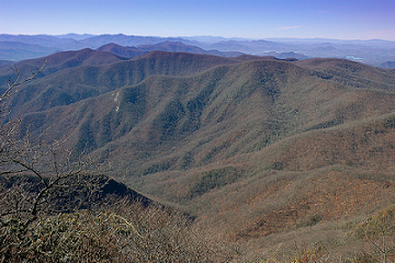
At 5,500 feet, Standing Indian is a strenuous 10-mile loop hike with a breathtaking panoramic view at the top. So why is this mountain called "Standing Indian"? According to Cherokee myth, the peak is the stone remains of an actual watchman, an Indian warrior sent to the mountaintop to keep a lookout for the winged monster that had stolen a village child. When the Great Spirit answered the village's prayers and destroyed the monster with a furious lightning storm, the mountain was shattered and the lone scout was turned to stone. The legend also "explains" the treeless heath or shrub bald summit, covered primarily with purple rhododendron. We start out just north of Tate City, at about 2,900 feet. We take the Beech Creek trail up to Case Knife Gap. From there, we do a very steep bushwhack straight up the side of the mountain to the AT, which will take us to the top of Standing Indian at 5,500 feet. We will eat our well-deserved lunch and then we will head down the AT to Deep Gap. There we pick up the Deep Gap trail, which goes along a stream back to where we started. This hike is approximately 10 miles with a total ascent of approximately 2,600'. The overall pace for this hike will be considered moderate, but we will be slowing down for the steep inclines and bushwhack section. If you are looking for a fast paced fitness hike, this is not the hike for you. Please be aware that you still need to be in excellent shape to attempt this hike. If you have not completed any D5 hikes recently, the trip leaders will contact you to determine your hiking experience and reserve the right to remove any registrants that they feel may not be able to keep pace with the group. After the hike on our way back to Atlanta, we will stop for dinner. If you do not intend to have dinner with the group, then plan on driving separately unless you can coordinate with others at the carpool who will need to return to Atlanta early. Thank you to Dean for initiating this hike within the AOC and for Stefan, who has taken many groups to this beautiful place! | |||||||||
| |||||||||
| How to Get There: | |||||||||
| Event Directions: |
| ||||||||
| Carpool to Event Distance (round trip): | 218Mile(s) | ||||||||
| Carpool Departure Time: | 7:30 am | ||||||||
| Carpool Location: | Log in for location | ||||||||
| Carpool Directions: | Log in for directions | ||||||||
| Carpool Cost: | Estimated cost per vehicle for this event is $87.20 using a reimbursement rate guideline of $0.400 per mile. The total amount should be divided by the number of people in the vehicle, including the driver. This is a guideline, not a rule, for drivers but the cost should not be higher unless there are extenuating circumstances. | ||||||||
| Notes: | |||||||||
|
We'll be traveling for several miles on windy gravel/dirt roads to the trailhead. Please keep this in mind when volunteering to drive. * We encourage all members to follow our Etiquette Guidelines while participating in AOC events. | |||||||||
Cancellation/Partial Attendance: Please review the AOC cancellation policy. | |||||||||
 Calendar of Events
 Event Places