 Print-Friendly Version Print-Friendly Version
|
|
Vineyard Mountain Eagle Scout Trail Early Afternoon Hike | |||||||
| The Basics: | |||||||
| Event Type: | Hike | ||||||
| Event Location: | Cartersville , GA 30121 | ||||||
| Date(s) & Time: | Wed, Nov 20 2013 3:30 pm >> Wed, Nov 20 2013 5:30 pm (Carpool Departure: 3:30 pm *log in for location*) | ||||||
| Registration Opens: | Tue, Nov 5 2013 7:00 pm | ||||||
| Registration Cut Off: | Tue, Nov 19 2013 7:00 pm | ||||||
| Event Duration: | 2 Hours | ||||||
| Difficulty Rating: | D3: Moderate | ||||||
| Distance: | 6 Miles | ||||||
| Pace: | Moderate | ||||||
| Trip Leader(s): | Isa Jimmy  Email Trip Leader(s) Email Trip Leader(s)
You must be logged in to get the Trip Leader contact information. | ||||||
| Member Cost: | None | ||||||
| Participant Info: | |||||||
| Who's Invited: | Members Only, 21 And Older Only | ||||||
| Maximum Group Size: | 10 | ||||||
| Minimum Group Size: | 4 | ||||||
| Number Registered So Far: | 9 / 0 (To see who's signed up, log in to the Member Area) | ||||||
| Are Dogs Permitted: | No | ||||||
| Itinerary: | |||||||
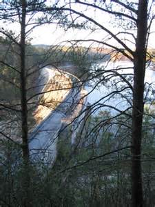
We will start this trail off of the red top mnt rd, the trailhead is on left before Bethany Bridge. A system made up of three different trails. The yellow blaze that leads through the mature wooded shoreline of lake Allatoona and on to some great views of the dam below from the ridge. The red blaze trail which ascends to the highest point of the trail system at Vineyard Mountain (Elevation: 1,354 Feet - Latitude: 340931N Longitude: 0844343W) and the blue blaze which leads up Vineyard Mountain from the 2nd trailhead at the Etowah River to quickly intersect with the yellow and red trails. We will head back to our car once we reach the end. I suggest bringing a flashlight or headlamp as it is getting darker earlier. | |||||||
| |||||||
| How to Get There: | |||||||
| Event Directions: | Heading northbound on I75. Exit 285 for Red Top Mtn Rd and make a right. Trailhead on left before Bethany Bridge. | ||||||
| Carpool to Event Distance (round trip): | 30Mile(s) | ||||||
| Carpool Departure Time: | 3:30 pm | ||||||
| Carpool Location: | Log in for location | ||||||
| Carpool Directions: | Log in for directions | ||||||
| Carpool Cost: | Estimated cost per vehicle for this event is $12.00 using a reimbursement rate guideline of $0.400 per mile. The total amount should be divided by the number of people in the vehicle, including the driver. This is a guideline, not a rule, for drivers but the cost should not be higher unless there are extenuating circumstances. | ||||||
| Notes: | |||||||
|
* We encourage all members to follow our Etiquette Guidelines while participating in AOC events. | |||||||
Cancellation/Partial Attendance: Please review the AOC cancellation policy. | |||||||
 Calendar of Events
 Event Places