 Print-Friendly Version Print-Friendly Version
|
|
Albert Mountain Backpack (Long Branch Shelter) | |||||||
| The Basics: | |||||||
| Event Type: | Backpacking | ||||||
| Event Location: |
Appalachian Trail Near Albert Mountain


| ||||||
| Date(s) & Time: | Sat, Jan 18 2014 10:30 am >> Sun, Jan 19 2014 5:00 pm (Carpool Departure: 8:00 am *log in for location*) | ||||||
| Registration Opens: | Mon, Dec 23 2013 8:00 pm | ||||||
| Registration Cut Off: | Fri, Jan 17 2014 4:00 pm | ||||||
| Event Duration: | Per Itinerary | ||||||
| Difficulty Rating: | D4: Moderate to Difficult (Exploratory) | ||||||
| Distance: | 12 Miles | ||||||
| Pace: | Moderate | ||||||
| Trip Leader(s): | Matthew Ballard Email Trip Leader(s) Email Trip Leader(s)
You must be logged in to get the Trip Leader contact information. | ||||||
| Member Cost: | None | ||||||
| Participant Info: | |||||||
| Who's Invited: | Members Only, 21 And Older Only | ||||||
| Maximum Group Size: | 8 | ||||||
| Minimum Group Size: | 4 | ||||||
| Number Registered So Far: | 8 / 0 (To see who's signed up, log in to the Member Area) | ||||||
| Are Dogs Permitted: | Yes | ||||||
|
Note: This is an "EXPLORATORY" trip. This means that there are parts of this trip, or perhaps the whole trip, that is new to your Trip Leader(s). However, they are confident that this will not be an issue. This note is here so that you can make an informed decision. When a Trip Leader isn't personally familiar with a trip, there is an increased chance of things not going as planned and you need to be prepared. The Trip Leader may have additional details in the itinerary. | |||||||
| Itinerary: | |||||||
Note: This posting has been updated to reflect the closing of the Big Spring Shelter and the opening of the New Long Branch Shelter. For this trip we will start from Standing Indian Campground and take Long Branch Trail up to Glassmine Gap on the Appalachian Trail. From Glassmine Gap we will follow the AT south toward Albert Mountain, once we arrive at Long Branch Shelter we will set up camp. Everyone is welcome to stay in the shelter if space is available, however I have marked a tent, hammock, or tarp as a requirement in the event the shelter is full. We will then continue to follow the AT south to the Albert Mountain bypass trail which we will use to loop to the south side of Albert. After scrambling up the south side of Albert if the weather is clear we will enjoy the view from the overlook and the stairs of the fire tower before returning to camp. We will break camp between 9:30am and 10:00am Sunday morning and return from Long Branch Shelter back to Standing Indian Campground. Approximately 8 miles of this trip will be with our full packs (~4 Miles in on Saturday and ~4 Miles out on Sunday) and approximately 4 miles of this trip will be pack less or with a light pack up to the top of Albert Mountain. The trip leader has hiked this section of the Appalachian Trail however the Long Branch Trail and the Albert Mountain Bypass Trail will be new to the trip leader as such this trip has been marked as exploratory. If you have not recently completed a D5 event with the AOC I will contact you to see if this event is appropriate for you. We will allow up to 2 well behaved dogs on this trip however you will be expected to bring appropriate winter weather gear to care for your dog. The event will go ahead rain or shine but not in severe weather. | |||||||
| |||||||
| How to Get There: | |||||||
| Event Directions: | Take I-85 N 10.8 miles to I-985 N Follow I-985 23.7 miles to GA-365 N / US-23 N After 28.9 miles take a slight left and continue to follow US-23 N / US-441 N toward Clayton After 43.7 miles turn left onto US-64 W After 11.9 miles turn left onto State Rd 1448 / Allison Creek Rd / W Old Murphy Rd After 1.9 Miles turn right onto National Forrest Service Rd Standing Indian Campground will be 1.6 Miles in on your right GPS Cordinates 35.076616 , -83.528391 | ||||||
| Carpool to Event Distance (round trip): | 248Mile(s) | ||||||
| Carpool Departure Time: | 8:00 am | ||||||
| Carpool Location: | Log in for location | ||||||
| Carpool Directions: | Log in for directions | ||||||
| Carpool Cost: | Estimated cost per vehicle for this event is $99.20 using a reimbursement rate guideline of $0.400 per mile. The total amount should be divided by the number of people in the vehicle, including the driver. This is a guideline, not a rule, for drivers but the cost should not be higher unless there are extenuating circumstances. | ||||||
| Notes: | |||||||
|
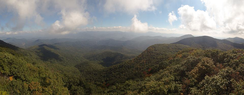
Thanks to Greg Pries for the wonderful promo picture from the top of the stairs on the Albert Mountain fire tower. * We encourage all members to follow our Etiquette Guidelines while participating in AOC events. | |||||||
Cancellation/Partial Attendance: Please review the AOC cancellation policy. | |||||||
 Calendar of Events
 Event Places