 Print-Friendly Version Print-Friendly Version
|
|
GA Pinhoti Trail - From Rt 136 going north | |||||||
| The Basics: | |||||||
| Event Type: | Hike | ||||||
| Event Location: | Near Resaca GA in Walker County | ||||||
| Date(s) & Time: | Sun, Mar 2 2008 11:30 am >> N/A (Carpool Departure: 10:15 am *log in for location*) | ||||||
| Registration Opens: | Tue, Feb 26 2008 12:00 am | ||||||
| Registration Cut Off: | Sat, Mar 1 2008 11:59 pm | ||||||
| Event Duration: | 5.5 hours, hiking and drive time | ||||||
| Difficulty Rating: | D3: Moderate | ||||||
| Trip Leader(s): | John Weatherman Email Trip Leader(s) Email Trip Leader(s)
You must be logged in to get the Trip Leader contact information. | ||||||
| Member Cost: | None | ||||||
| Participant Info: | |||||||
| Who's Invited: | Members Only, 21 And Older Only | ||||||
| Maximum Group Size: | 18 | ||||||
| Minimum Group Size: | 4 | ||||||
| Number Registered So Far: | 8 / 0 (To see who's signed up, log in to the Member Area) | ||||||
| Are Dogs Permitted: | Yes | ||||||
| Itinerary: | |||||||
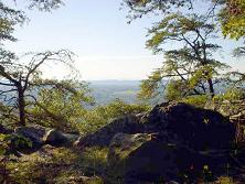
This is a six- to eight-mile, medium difficulty, in-and-out hike. Most of it is pretty flat. The Pinhoti Trail is a long trail that connects the base of the Appalachians in Alabama with the Benton McKaye Trail in the Cohuttas in Georgia, or at least it will if it is ever all connected up. There are long sections of it complete in Georgia. We will be doing a piece of that. This is in the ridge-valley section of Georgia, so the terrain is a little different from the Blue Ridge. Here the ridges here are low, long and straight. The forest is newer and there is more pine. The rocks are different. We will make a short ascent from the parking lot to the top of Mill Creek Mountain. From there we will follow the low flat ridge top north. We will have long winter views to the east and west all along the way. At the end of the ridge we will make a short descent into a little valley and go back up to another ridge top, this time, Hurricane Mountain. After a bit on this, we will have done enough for the day, and turn around and go back the same way we came. | |||||||
| |||||||
| How to Get There: | |||||||
| Event Directions: | Get on I75-North. Go 49 miles to exit 320. Make pit stop at Flying J truck stop on the right. Go left on GA 136 out of truck stop. Go about eight miles to Pinhoti parking lot on the right. There should be a sign there. | ||||||
| Carpool to Event Distance (round trip): | 116Mile(s) | ||||||
| Carpool Departure Time: | 10:15 am | ||||||
| Carpool Location: | Log in for location | ||||||
| Carpool Directions: | Log in for directions | ||||||
| Carpool Cost: | Estimated cost per vehicle for this event is $46.40 using a reimbursement rate guideline of $0.400 per mile. The total amount should be divided by the number of people in the vehicle, including the driver. This is a guideline, not a rule, for drivers but the cost should not be higher unless there are extenuating circumstances. | ||||||
| Notes: | |||||||
|
* We encourage all members to follow our Etiquette Guidelines while participating in AOC events. | |||||||
Cancellation/Partial Attendance: Please review the AOC cancellation policy. | |||||||
 Calendar of Events
 Event Places