 Print-Friendly Version Print-Friendly Version
|
|
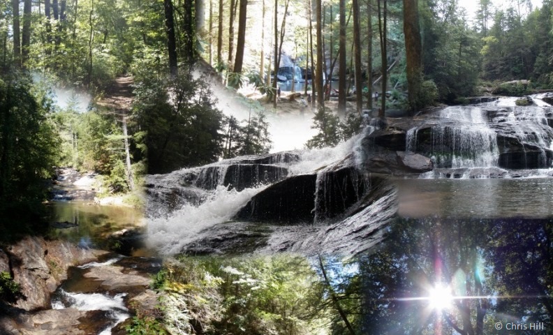
Panther Creek Falls: Waterfall Hike (Optional Swim) | |||||||
| The Basics: | |||||||
| Event Type: | Hike | ||||||
| Event Location: |
Turnerville, GA


| ||||||
| Date(s) & Time: | Sun, May 18 2014 9:30 am >> Sun, May 18 2014 3:30 pm (Carpool Departure: 8:00 am *log in for location*) | ||||||
| Registration Opens: | Wed, May 7 2014 9:11 pm | ||||||
| Registration Cut Off: | Sat, May 17 2014 12:34 pm | ||||||
| Event Duration: | 6 Hours | ||||||
| Difficulty Rating: | D5: Difficult | ||||||
| Distance: | 12 Miles | ||||||
| Pace: | Moderate | ||||||
| Trip Leader(s): | Chris H Hilke Neuerburg  Email Trip Leader(s) Email Trip Leader(s)
You must be logged in to get the Trip Leader contact information. | ||||||
| Member Cost: | None | ||||||
| Participant Info: | |||||||
| Who's Invited: | Members Only, 21 And Older Only | ||||||
| Maximum Group Size: | 12 | ||||||
| Minimum Group Size: | 2 | ||||||
| Number Registered So Far: | 4 / 0 (To see who's signed up, log in to the Member Area) | ||||||
| Are Dogs Permitted: | No | ||||||
| Itinerary: | |||||||
Overview: Flowing southeasterly, the Panther Creek Recreational Area's namesake, Panther Creek winds through stands of white pine and hemlock south of Tallulah Gorge. From the parking area just north of Turnerville, GA, the blue blazed trail descends to the journey's feature attraction, Panther Creek Falls, and then continues a few miles (or so) to Davidson Creek. Details: Our 12 mile hike will descend approximately 3.3 miles past rocky shoals from the parking area to the falls, where we will pause to soak in nature and have an early lunch (or a snack for the less peckish). This portion of the trail can be steep at times and has a few narrow areas. From there we will continue an additional 2.7 miles (or so) to the bridge across Davidson Creek. Please note that the part of the trail below the falls has some very steep, rocky climbs, with the potnetial need to climb around or over fallen trees. However, this part of the trail is different than the initial portion, in a good way, as it involves more elevation change and the forest service has given it a special designation of "Panther Creek Botanical Area" for its unique flora and fauna. This area of the forest also contains larger, more mature, forest species of Oak, Tuliptree, Basswood, and American Beech. On our return we will include a longer stop at the falls for a second snack (or lunch) and swimming for those who so choose. While this trail is challenging at times, we plan to take a moderate to fast pace on this hike (minimum average of 3 mph), which is a faster pace than past hikes on this route. Due to the combination of the technical nature of the trail and our planned pace, the Trip Leaders will be contacting you if you do not have an established reputation as a strong D4/D5 hiker to determine if this is the right event for you. There is a very steep ascent of approximately 650' between Davidson Creek and the bottom of the falls. In this one mile section, it will be roughly the equivalent of a Stone Mountain ascent. Members should expect to cover at least 2000' of total ascent on this trail. Those who might opt to swim should bring appropriate swimming attire. There is a $4 fee to park at the Panther Creek Recreation Area. | |||||||
| |||||||
| How to Get There: | |||||||
| Event Directions: | Travel north on GA 400 until it ends in Dahlonega. Continue north onto GA 115 (straight at the Waffle House). Turn right onto GA 115/GA 52 at the stop light. Follow GA 115 through Cleveland and into Clarkesville. At the light in downtown Clarkesville, turn left onto US 441 Historical/Washington Street. This road takes a sharp right turn on GA 385/GA 441 Historical almost immediately. Follow GA 385/US 441 Historical (you'll see a Kangaroo gas station ahead on your right). Turn right onto GA 385 and take the next left onto GA 441 at the stop light. Drive ~3.5 miles north on US 441 and turn left onto Travis Smith Road. Turn right onto US 441-Historical and the parking area will be ahead on the left within a mile. Printed Directions will be supplied to the drivers at the carpool. | ||||||
| Carpool to Event Distance (round trip): | 160Mile(s) | ||||||
| Carpool Departure Time: | 8:00 am | ||||||
| Carpool Location: | Log in for location | ||||||
| Carpool Directions: | Log in for directions | ||||||
| Carpool Cost: | Estimated cost per vehicle for this event is $64.00 using a reimbursement rate guideline of $0.400 per mile. The total amount should be divided by the number of people in the vehicle, including the driver. This is a guideline, not a rule, for drivers but the cost should not be higher unless there are extenuating circumstances. | ||||||
| Notes: | |||||||
|
Do not forget to bring cash for your driver and to help with the $4 (cash only) parking fee.
* We encourage all members to follow our Etiquette Guidelines while participating in AOC events. | |||||||
Cancellation/Partial Attendance: Please review the AOC cancellation policy. *Note: This is a rain or shine event, but lightning and tornadoes just might lead to a cancellation. Your Trip Leaders will notify registrants as quickly as possible. | |||||||
 Calendar of Events
 Event Places