 Print-Friendly Version Print-Friendly Version
|
|
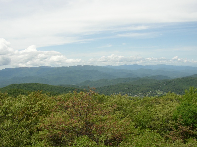
Rabun Bald and Bartram Trail lookout rock | |||||||
| The Basics: | |||||||
| Event Type: | Hike | ||||||
| Event Location: |
nr Clayton, Ga


| ||||||
| Date(s) & Time: | Sun, Jun 1 2014 7:30 am >> Sun, Jun 1 2014 8:00 pm (Carpool Departure: 7:30 am *log in for location*) | ||||||
| Registration Opens: | Wed, May 28 2014 9:00 pm | ||||||
| Registration Cut Off: | Sun, Jun 1 2014 6:00 am | ||||||
| Event Duration: | per itinerary | ||||||
| Difficulty Rating: | D5: Difficult | ||||||
| Distance: | 12 Miles | ||||||
| Pace: | Moderate | ||||||
| Trip Leader(s): | Dorothea Clay White  Email Trip Leader(s) Email Trip Leader(s)
You must be logged in to get the Trip Leader contact information. | ||||||
| Member Cost: | None | ||||||
| Participant Info: | |||||||
| Who's Invited: | Members Only, 21 And Older Only | ||||||
| Maximum Group Size: | 12 | ||||||
| Minimum Group Size: | 4 | ||||||
| Number Registered So Far: | 12 / 0 (To see who's signed up, log in to the Member Area) | ||||||
| Are Dogs Permitted: | No | ||||||
| Itinerary: | |||||||
Rabun Bald is the second highest mountain in Georgia. There are several ways of climbing it; this is the toughest, but it is pretty. We ascend via the Three Forks Trail, which climbs 2200 ft in three miles, with the last half mile inclined at the pitch of a staircase. The reward is a spectacular 360-degree view from the summit lookout tower. From the tower we descend south on the Bartram Trail, through Flint Gap and Saltrock Gap, then up and around Flat Top Mountain, and down again to the lookout rock, just before Wilson Knob. There we will have lunch and turn around. The total distance is 12 miles with 3800 ft of elevation gain. With stops the hike should take about 7 hours. Clay will coordinate the carpool at the Indian Trail park-and-ride and Dorothea will join the group at the Burger King in Clayton, where we will make a brief pit-stop. | |||||||
| |||||||
| How to Get There: | |||||||
| Event Directions: | From the Indian Trail park & ride, take I-85 North. After 11 miles bear left to take I-985 North. This road will change to GA 365, US 441, and US 23. Stay on it for 75 miles, then stop for a break at the Burger King in Clayton. From Clayton take Warwoman Rd east for 10.3 miles, turn left on the Hale Ridge Rd/Forest Service Rd 7 (note the sign: “Hale Ridge cemetery 3.5 miles”) and drive 5.7 miles to the trailhead. | ||||||
| Carpool to Event Distance (round trip): | 200Mile(s) | ||||||
| Carpool Departure Time: | 7:30 am | ||||||
| Carpool Location: | Log in for location | ||||||
| Carpool Directions: | Log in for directions | ||||||
| Carpool Cost: | Estimated cost per vehicle for this event is $80.00 using a reimbursement rate guideline of $0.400 per mile. The total amount should be divided by the number of people in the vehicle, including the driver. This is a guideline, not a rule, for drivers but the cost should not be higher unless there are extenuating circumstances. | ||||||
| Notes: | |||||||
|
* We encourage all members to follow our Etiquette Guidelines while participating in AOC events. | |||||||
Cancellation/Partial Attendance: Please review the AOC cancellation policy. *Note: Since this is a strenuous hike, I will be contacting anyone who has not done at least a D4-level AOC hike to determine whether this is a suitable hike for you. | |||||||
 Calendar of Events
 Event Places