Backpacking Joyce-Klimer Wilderness / Wildcat Falls
|
|
The Basics: |
| Event Type: |  | Explorer | |
|
Event Location: | |
Joyce-Kilmer Slickrock WIlderness
| |
| Date(s) & Time: | | Sat, Sep 13 2014
10:00 am >> Sun, Sep 14 2014 5:00 pm (Carpool Departure: 6:30 am *log in for location*)
| |
| Registration Opens:
| |
Mon, Sep 1 2014 9:00 pm
| |
| Registration Cut Off:
| |
Thu, Sep 11 2014 12:00 pm
| |
| Event Duration: | | Overnight backpack trip | |
| Difficulty Rating: | | D6: Advanced (Exploratory) | |
| Distance: | | 18 Miles | |
| Pace: | | Fast | |
Trip Leader(s):
| | John L
Paula Schubert
 Email Trip Leader(s) Email Trip Leader(s)
You must be logged in to get the Trip Leader contact information.
| |
| Member Cost: | | None |
|
| Participant Info: |
| Who's Invited: | |
Members Only, 21 And Older Only
| |
| Maximum Group Size: | | 8 |
| Minimum Group Size: | | 4 |
| Number Registered So Far: | |
4 / 0 (To see who's signed up, log in to the Member Area)
|
| Are Dogs Permitted: | |
No
|
|
Note: This is an "EXPLORATORY" trip. This means that there are parts of this trip, or perhaps the whole trip, that is new to your Trip Leader(s). However, they are confident that this will not be an issue.
This note is here so that you can make an informed decision. When a Trip Leader isn't personally familiar with a trip, there is an increased chance of things not going as planned and you need to be prepared. The Trip Leader may have additional details in the itinerary.
|
| Itinerary: |
Are looking for a challenging backpacking adventure? Want to see something new and different? We've got one for you.
We'll be spending 1 night in the wonderful Joyce Kilmer Wilderness. This trip is rated a D6 because of total distance (18+ miles, elevation gain and the fact we are attempting to squeeze into 2 days / 1 night what is normally done in 3 days / 2 nights.
Joyce Kilmer Wilderness is a virgin forest with many trees that are over 200 years old.
http://www.wilderness.net/NWPS/wildView?WID=280
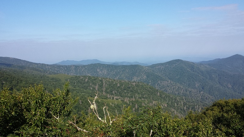
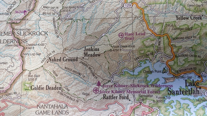
We'll park at the remote Wolf Laurel trailhead in the Wolf Laurel Basin and hike a clockwise loop. We will make quick work of a 700'+ climb to Bob Stratton Bald. From there we will trek along a ridgeline through Cherry Log Gap, Chestnut Knob, Rockstack and Big Fodderstack. There should be plenty of scenic views along the way and we'll stop to eat when the group needs to. Since we have a lot of distance to cover, we will then hike quickly along Big Stack Gap Branch Trail and work our way down to Slickrock Creek trail and Wildcat Falls, our campsite destination for the night. Total Distance for Day 1 is about 9 miles.
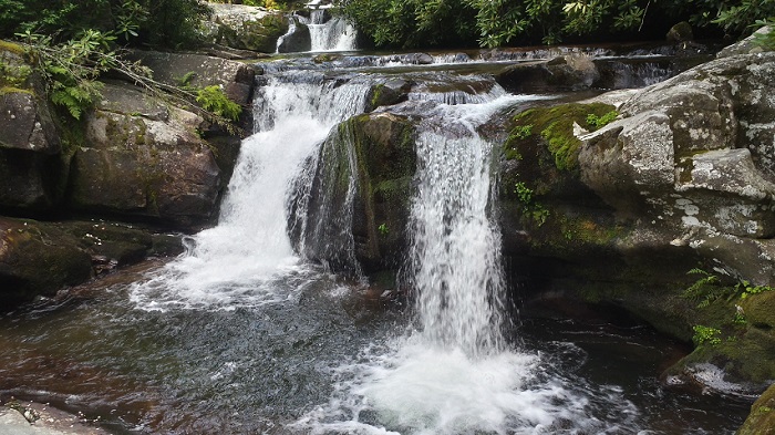
Wildcat Falls has a series of 4 cascading falls and is breathtaking. There are a few creek crossings here so bring water shoes. The water is cold, but it's a great spot to swim and cool down. We will clean up, eat dinner, relax and settle in for the night.
The next morning we will break camp early and make a difficult hike out up of the basin. We will backtrack just a little to Big Fat Trail and hike up to Big Fat Gap Trailhead. From there we continue up to the famous "Hangover" which offers 360 views all around.
Finally, from Hangover we will hike to Naked Ground, then back to Wolf Laurel Basin to our vehicles. I estimate the total distance to be 18+ miles (9 miles each day) and over 2500+ feet in elevation gain. You must have previous backpacking experience and be able to hike a brisk pace. Trip leaders will contact you if you have not completed any recent D5 hikes. Dogs will not be permitted.
If time permits, we will stop for dinner on the way home. It will be a group decision. |
|
Required Items to Bring:
Tent
Sleeping bag / pad
Sturdy boots
Water shoes
Food / Snacks (Sat. Lunch /Dinner, Sunday Breakfast / Lunch)
Bear Bag / Cannister / Ropes
Water / Drinks (you should carry at least 3 liters)
Water Filter
Headlamp
| | Recommended Items to Bring:
Use our Event Checklists to make sure you have everything you need.
Bug spray
Stove / Jetboil
Long pants / gators (lots of brush to walk through)
Towel
Treking poles
Camera
Rain gear (just in case)
Warm clothing (if it does get cool) | |
|
| How to Get There: |
| Event Directions: | | Head north on GA-5 N/I-575 N (27.9 mi)
Continue onto GA-515 E (41.2 mi)
Turn left onto W 1st St (295 ft)
Continue onto GA-5 N/Blue Ridge Dr
Continue to follow GA-5 N (Entering Tennessee - 10.2 mi)
Turn left onto Toccoa Ave (289 ft)
Continue onto TN-68 N/Ocoee St
Continue to follow TN-68 N (36.4 mi)
Turn right onto Cherohala Skyway (Entering North Carolina - 25.5 mi)
Follow National Forest Rd to Wolf Laurel Rd (6.5 mi)
Turn left onto Old Santeetlah Rd (0.1 mi)
Continue onto National Forest Rd (3.9 mi)
Sharp left onto Wolf Laurel Rd (2.5 mi)
Park at Wolf Laurel Basin trailhead | |
| Carpool to Event Distance (round trip): | | 330Mile(s) |
| Carpool Departure Time: | |
6:30 am
|
| Carpool Location: | |
Log in for location
|
| Carpool Directions: | |
Log in for directions
|
| Carpool Cost: | |
Estimated cost per vehicle for this event is $132.00 using a reimbursement rate guideline of $0.400 per mile. The total amount should be divided by the number of people in the vehicle, including the driver. This is a guideline, not a rule, for drivers but the cost should not be higher unless there are extenuating circumstances.
|
|
| Notes: |
|
We hope to get a selfie with a live bear. That is the ultimate goal of this trip.
Seriously, this area is known to have bears and wild boar. I have been there once and did not see any, and for the most part they are afraid of us since they are hunted there. That being said, be prepared. This is a Wilderness hike. The trails are very rugged and not maintained.
|
|
Cancellation/Partial Attendance: Please review the AOC cancellation policy. |
 Print-Friendly Version
 Calendar of Events
 Event Places