 Print-Friendly Version Print-Friendly Version
|
|
For the most Gorge-ous Fall Colors in Georgia...Hike Cloudland Canyon! | |||||||
| The Basics: | |||||||
| Event Type: | Hike | ||||||
| Event Location: |
NW GA near Chattanooga


| ||||||
| Date(s) & Time: | Sun, Nov 2 2014 10:00 am >> Sun, Nov 2 2014 3:00 pm (Carpool Departure: 8:00 am *log in for location*) | ||||||
| Registration Opens: | Wed, Oct 29 2014 10:00 pm | ||||||
| Registration Cut Off: | Sat, Nov 1 2014 6:00 am | ||||||
| Event Duration: | 5 Hours | ||||||
| Difficulty Rating: | D4: Moderate to Difficult | ||||||
| Distance: | 10 Miles | ||||||
| Pace: | Moderate | ||||||
| Trip Leader(s): | Charlie Cottingham Email Trip Leader(s) Email Trip Leader(s)
You must be logged in to get the Trip Leader contact information. | ||||||
| Member Cost: | None | ||||||
| Participant Info: | |||||||
| Who's Invited: | Members Only, 21 And Older Only | ||||||
| Maximum Group Size: | 15 | ||||||
| Minimum Group Size: | 2 | ||||||
| Number Registered So Far: | 13 / 0 (To see who's signed up, log in to the Member Area) | ||||||
| Are Dogs Permitted: | No | ||||||
| Itinerary: | |||||||
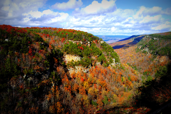
IN A NUTSHELL: Known for its beautiful vistas, brilliant fall foliage, spectacular waterfalls, and incredible hiking trails, Cloudland Canyon State Park is perhaps the #1 "crown jewel" of Georgia's parks and natural areas. An easy 2-hour drive from Atlanta, it's just south of Chattanooga, where over the millennia powerful streams have cut steep-walled canyons and waterfalls into the western side of Lookout Mountain. On this fall day trip we'll enjoy a series of hikes to vista points along the canyon rim - also to the waterfalls deep inside the canyon via an amazing trail network and stairway. ARTS & CRAFTS & MUSIC CELEBRATION (Sat & Sun, 10A-5P, in the Park): Caution! Cars backed up at the Park entrance for this big 2nd annual event could possibly delay our ~9:30-ish entry into the Park, so don't dilly-dally en route up! It will be in the Group Picnic Shelter area near the Park entrance and several thousand visitors may attend as they did last year. Let's all do our best to be on time for our 10:00 AM AOC group gathering time (by the restroom building a mile north of the Park entrance) but if necessary we can delay beginning our hike a bit due to the possible vehicle backup. (If you - or we - are running late we'll try to reach you by cell phone.) In any case, before returning home some of our carpool groups may wish to check out the "Celebration" (between 3PM and 5PM) esp. since it will also offer various FOOD items or sale. Festival Admission is just $5 per carload of visitors, payable at the Group Shelter entrance. Click here for more info in case you're interested: Mountain Arts, Crafts & Music Celebration Website MORE about CLOUDLAND CANYON STATE PARK: Founded in 1938 it now boasts 3485 acres of amazing terrain with 1100 feet of vertical elevation between its lowest and highest points The steep twin canyons cut by Daniel Creek and Bear Creek join one another hundreds of feet below the mesa-like mountaintop, forming the deeper, wider "Sitton Gulch Creek" canyon and numerous scenic waterfalls, cascades and pools. (The photo above was shot from the Park's central overlook looking northward into the main canyon.) For an excellent color Trail Map click this link: http://gastateparks.org/Parks/images/cloudland/CloudlandCanyon-2013.pdf For dozens of great Cloudland Canyon photos click this link: | |||||||
| |||||||
| How to Get There: | |||||||
| Event Directions: |
GPS and GOOGLE MAPS USERS: You may wish to augment the above written directions by entering the following Lat/Lon coordinates (as you would a street address) as your destination for our 10:00 AM meetup spot: 34.83473,-85.47988 | ||||||
| Carpool to Event Distance (round trip): | 200Mile(s) | ||||||
| Carpool Departure Time: | 8:00 am | ||||||
| Carpool Location: | Log in for location | ||||||
| Carpool Directions: | Log in for directions | ||||||
| Carpool Cost: | Estimated cost per vehicle for this event is $80.00 using a reimbursement rate guideline of $0.400 per mile. The total amount should be divided by the number of people in the vehicle, including the driver. This is a guideline, not a rule, for drivers but the cost should not be higher unless there are extenuating circumstances. | ||||||
| Notes: | |||||||
|
* We encourage all members to follow our Etiquette Guidelines while participating in AOC events. | |||||||
Cancellation/Partial Attendance: Please review the AOC cancellation policy. | |||||||
 Calendar of Events
 Event Places