 Print-Friendly Version Print-Friendly Version
|
Cooper Creek WMA and Georgia’s Champion Poplar Tree | |||||||
| The Basics: | |||||||
| Event Type: | Hike | ||||||
| Event Location: |
Near Suches, Ga


| ||||||
| Date(s) & Time: | Sun, Dec 7 2014 8:00 am >> Sun, Dec 7 2014 5:00 pm (Carpool Departure: 8:00 am *log in for location*) | ||||||
| Registration Opens: | Tue, Dec 2 2014 8:48 pm | ||||||
| Registration Cut Off: | Sat, Dec 6 2014 10:10 am | ||||||
| Event Duration: | 9 Hours | ||||||
| Difficulty Rating: | D5: Difficult (Exploratory) | ||||||
| Distance: | 12 Miles | ||||||
| Pace: | Moderate | ||||||
| Trip Leader(s): | Mark Laura V  Email Trip Leader(s) Email Trip Leader(s)
You must be logged in to get the Trip Leader contact information. | ||||||
| Member Cost: | None | ||||||
| Participant Info: | |||||||
| Who's Invited: | Members Only, 21 And Older Only | ||||||
| Maximum Group Size: | 14 | ||||||
| Minimum Group Size: | 4 | ||||||
| Number Registered So Far: | 13 / 0 (To see who's signed up, log in to the Member Area) | ||||||
| Are Dogs Permitted: | Yes | ||||||
|
Note: This is an "EXPLORATORY" trip. This means that there are parts of this trip, or perhaps the whole trip, that is new to your Trip Leader(s). However, they are confident that this will not be an issue. This note is here so that you can make an informed decision. When a Trip Leader isn't personally familiar with a trip, there is an increased chance of things not going as planned and you need to be prepared. The Trip Leader may have additional details in the itinerary. | |||||||
| Itinerary: | |||||||
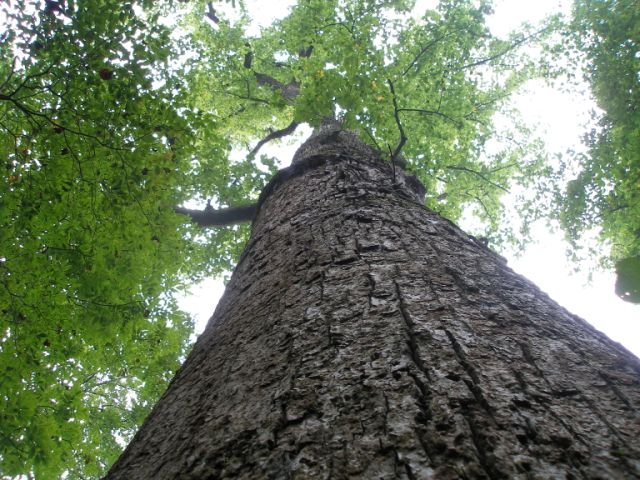
Please read this ENTIRE event description prior to signing up for this event. The 1,240-acre Cooper Creek Scenic Area, which ranges between 2,000 and 3,000 feet in elevation, is surrounded by more than 34,000 acres of the Cooper Creek Water Management Area and the slightly larger, overlapping Cooper Creek Wildlife Management Area. Cooper Creek, a cold mountain trout stream, runs approximately 2 miles down the center of the scenic area. There are stands of large hemlock, yellow poplar, oak, and white pine, reaching 3 and 4 feet in diameter, along its tributaries. Additionally, Georgia's Champion Tulip Poplar, measuring nearly 20 feet in circumference is located in the area. The trails in this wildlife management area offer many miles of hiking. Itinerary: We will begin our hike on the east end of the Old Growth Forest Trail. This trail will lead us through some stands of very large hemlocks, oaks, white pines, and tulip poplars - near the end of this trail, we will visit the Georgia's Champion Tulip Poplar tree. We will then continue off-trail for about 1.25 miles until we near the Mulky Campground. After crossing the road, we will hike the 1.6 mile Eyes On Wildlife Trail, which is a loop trail. We will then go to the other side of the campground and hike the Yellow Mountain Trail, Cooper Creek Connector Trail, Mill Shoals Trail, Shope Trail, until we connect back into the Yellow Mountain Trail. We will then continue on the Yellow Mountain Trail to its end. At this point we will hike down a forest service road for a short distance and then make our way into the woods "off-trail." We will hike approximately a half mile through the woods, cross Cooper Creek, and then approximately another ¼ mile until we reach the Old Growth Forest Trail, which we will take back to our autos. The hike will be about 12 miles and have roughly 2,300 feet of ascent. This hike will entail hiking on approximately 9 miles of marked trails, 1 mile of FS road, and 1.5 - 2 miles off-trail. We will also have to cross the ice-cold Cooper Creek in the last 1/2 mile of the hike. The crossing is no more than shin deep, but you will probably want to remove your shoes/boots and dry your feet on the other side. Here's a photo album from the previous time I did this hike. Disclosure: Although your TLs have hiked about 90% of these trails, it has been a few years ago, so there's a slight chance that things could have changed a bit. There is also one off-trail section we have not hiked. Therefore we have listed this hike as exploratory and you should have a sense of adventure and a flexible attitude.
| |||||||
| |||||||
| How to Get There: | |||||||
| Event Directions: | Directions to be provided at carpool | ||||||
| Carpool to Event Distance (round trip): | 134Mile(s) | ||||||
| Carpool Departure Time: | 8:00 am | ||||||
| Carpool Location: | Log in for location | ||||||
| Carpool Directions: | Log in for directions | ||||||
| Carpool Cost: | Estimated cost per vehicle for this event is $53.60 using a reimbursement rate guideline of $0.400 per mile. The total amount should be divided by the number of people in the vehicle, including the driver. This is a guideline, not a rule, for drivers but the cost should not be higher unless there are extenuating circumstances. | ||||||
| Notes: | |||||||
|
* We encourage all members to follow our Etiquette Guidelines while participating in AOC events. | |||||||
Cancellation/Partial Attendance: Please review the AOC cancellation policy. | |||||||
 Calendar of Events
 Event Places