Fri, Jan 8 2010 - Linville Gorge Southern End (View Original Event Details)
| Trip Leader(s): |  |
Matt Tichenor, Rob Garner
|
| Participants: | | Rob Garner, Matt Tichenor, Dirk, Jason Kotz, Jeff Price, Logan Ballesteros, Pavan |
| 
Click for Album |
Write Up:Rob, Matt, Jeff, Jason, and Dirk left ATL around 6:20 am on Friday, the day that a quarter inch of snow paralyzed Atlanta. Surprising the snow dissappears very soon as we head north on I-85. We reach Asheville, pick up Logan, hit REI, and drive through a few flurries before ascending on the ice covered road to the Pinch In trailhead. Temperature at our 11:30 backpacking adventure departure is 13 degrees.
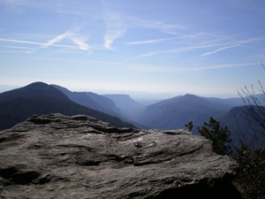
We head out on the Pinch In trail and quickly start heading down.. and quite rapidly. Since a fire had burned through the area years before, we have an unobstructed view of the Gorge, with its famous 2000 walls on the east and west dropping to the rugged Linville River. We reached the floor commenting to each other that we would not want to climb up that trail since it seemed incredibly steep and long (See Interest fact 1 below). We head north up the gorge toward the only walking bridge within the park boundary. This "flat" section does offer a few brief flat sections but in reality you do quite a few up and downs as you ascend along with the river from 1450 to 2100 feet in elevation. These elevation changes make the Linville River the epitome of a rugged, wilderness river and is a place that you simply must visit. We arrive at the lone bridge to our warmest temperatures on the trip, maybe 25. We filter water from a creek, and begin the ascent up the east side of the gorge.
Sometimes you go straight instead of taking a left and end up on a slightly different route. Most days that would not really be a big deal, unless of course it leads to a unexpected climb, post-holing up a steep slope on what may or may not be an actual trail. This is the first backpacking trip I have been on where "post-holing" was one of the challenges. Post-holing occurs when you are walking on an icy crust and you break through into the soft snow below, in our case up to our knees in some cases. The 2 feet of snow Linville Gorge had received 2 weeks prior had mostly melted in the lower elevations near the river, but above 3000 feet and along the northern exposed ridges, the snow was still 6 to 18 inches deep covered with and icy crust. Winter days are short, so we are also battling rapidly dropping temperature and depleted energy levels. We finally make it to the top as twilight sets in, connect with the MST (Mountains to Sea Trail) and follow that to the Table Rock parking lot. This lot was not our scheduled destination but it had one thing we were were not going to turn down at that point, an enclosed shelter. We huddle in the shelter that was still bitter cold, but at least out of the now gusting winds. We eat, warm up, and 3 of us (Matt, Jason, Dirk) set up our tents on top of the thick icy crust while the other 3 (Rob, Logan, and Jeff) decide to sleep in the enclosed shelters, AKA the pit toilets! Luckily the pits must have been recently cleaned or the goods were just frozen solid! Jason and Matt set their tents up next to the sign stating "Do not block road" in the parking lot. Of course the parking lot was not accessible by car thanks to the 75 mph winds that occurred a few weeks earlier and had littered the area with downed trees and broken branches. Luckily the ice was thick enough to support our tents and firmly held the stakes as well.
Friday night was just crazy cold. That night Matt, Jason, and Dirk endured loud, gusty winds that shockingly did not destroy our tents. In the pits, Rob decided that Jeff was snoring too loudly so he switched from the Womans to the Mens room, much to the surprise of Logan. Saturday morning my thermometer said 9 degrees, but that was actually partially inside my disheveled tent, so it may have been closer to 5. Wind chill was well below zero no doubt. When we woke up Saturday morning several of us we still were a bit shell shocked from everything, so we made a decision to head back north, so we would cross on a bridge rather than risk a very frigid and gusty ridgeline hike with a potential river crossing. You really need temps above freezing to attempt a river crossing, or the frostbite danger is too high.
We began to hike and first we took the MST around Table Rock and took a 0.3 mile side trail to the top on a very icy trail. Rob slipping and almost sliding down a cliff was pretty cool; just kidding a few trees would have likely caught him. We then continued north on the MST and post-holed for about a half mile until we finally got below the snow pack. This section was especially challenging since the sidehill was completely filled in with snow and covered with ice at times. We passed what would have been our nearly ideal, wind-protected, campsite if we had not taken our slight detour. We soon arrived at the Spence trailhead, which is by far the easiest way down to the Spence bridge (probably a D2/D3 hike) and took the well graded trail back to the Linville River and hiking bridge. After stopping for lunch and filtering more water, we crossed the bridge and proceeded south in search of a campsite. We found a great site along the river, and finally built a much needed fire. By this time the temperature was probably around 20, and after freezing up 3 filters in a row, we resorted to boiling our water. We chatted, listened to a few tunes, and hit the sack by 9:00.
Sunday morning was cold with calm winds. Jason and Matt departed early for the short hike back to the cars. We felt fortunate to have the GPS since the trail was pretty difficult to follow at times. We arrived at the bottom of the Pinch In trail knowing it was going to be beast, but thankful it was all we had left. We trudged up the west gorge wall at 1 mph, and completed our modified yet satisfying journey. The temp at the parking lot was 21 degrees. Our 3 day adventure in Linville Gorge was below 25 degrees in its entirety meaning pizza and beer were in order. Barleys in Asheville was excellent, and we were back in ATL by 5:00pm.
Stats:
Day 1: 7.8 miles 3100 ascent
Day 2 6.7 miles 1400 ascent
Day 3: 2.5 miles 2000 ascent
Trip: 17.0 miles 6500 ascent (and of course 6500 descent as well). It would be interesting to know how many blowdowns we had to climb over/under as well (I would guess 50).
Interest facts:
1) The initial descent (final ascent) was 1800 vertical in 1.2 miles including an impressive 1000 foot drop in 0.57 miles (rate of 1754 vertical/mile). For comparison, the steepest 300 foot section of the AT Albert Mountain ascent rate is 1665 vert/mile and part of that is hand over hand climbing. Stecoah Gap has a similar steepness that is 1600 vert/mile on its steepest 400 foot section. I know of no other mapped trail in the southest that is that steep over 1000 feet of actual vertical. if anyone else does, I'd love to hike it!
2) The last climb at the end of Day 1 was 857 vertical in 0.63 miles (rate of 1360 vertical/mile). Combine that rapidly dropping temps and postholing into a thin icy crust on top of 6 to 18 inches of snow.
 Calendar of Events
 Event Places