Sat, Jun 19 2010 - Shining Rock Wilderness backpacking (View Original Event Details)
| Trip Leader(s): |  |
Michael J, Bob Bunner
|
| Participants: | | Michael J, Bob Bunner, Jason C, steve, Gordon D, Kim Abrams, Helena F, Brian Clements |
| 
Click for Album |
Write Up:When we needed a break from the hot summer in Atlanta, what better way to do that than to head to the mountains in the Shining Rock Wilderness and specifically, the namesake for the wilderness, Shining Rock. We began our backpacking loop at the Big East Fork trailhead on US 276. For the first 3-4 miles, we hiked along the Pigeon River. Usually the river was within our sight, but if not, we could hear the roar of the river in the background. The water in the river is crystal clear, but the bottom of the river bed has a copper like color, suggesting that "there's gold in there hills." Or maybe not.
At the junction of the Grassy Cove Prong, we ate lunch on the rocks. This made us laugh later on, because we sat next to the cairns marking the necessary crossing we needed to make to ascend up the Grassy Cove ridge, but we didn't see the trail across the way and proceeded, after lunch, along the Pigeon before turning around and getting on the right path. This is not unusual in the Shining Rock Wilderness. With a vast network of trails, it is common for hikers to have to retrace their paths to find the right trail. If you go in the future, make sure you bring a compass and a map.
Now we began our ascent, where we gained around 2,000 feet in the next 3 miles. There were lots of downed trees and another river crossing, as we encountered bloody arms and legs while making our way (a/k/a bushwhacking) through blackberry vines that were not even close to being ripe yet. But our luck would change as we proceeded up to Grassy Cove Top (love these names). By God, whoever named this place knew what he was talking about. For about a mile, we traveled through tall green grass with an occasional tree here and there. The grass was lush and beautiful and made us all glad that Mike picked this route because none of us had seen anything quite like this before.
Eventually, we made it to the Art Loeb Trail, which runs along the ridge in the heart of the Shining Rock Wilderness, primarily in a North-South direction. We headed North, across Flower Gap, which looked like a nice place for a campsite in the tall grass and above the trees. But Mike convinced us to continue on because there was water ahead and we would be camping closer to Shining Rock. We found a nicely wooded campsite just beyond Shining Rock Gap. The area in general resembles a crowded campground, as lots of campers converge to this area to be near Shining Rock. But our little camping area gave us a little isolation from the masses. I should also point out that the water source is little more than a trickle, so make sure you bring a filter so you can get the water out of a hole if need be.
We set up camp, with Gordon, Brian and Steve setting up hammocks to sleep in, while the rest of us felt old-fashioned as we erected our tents. Kim took a long nap. The rest of us fetched water and made dinner.
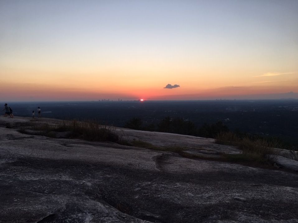
After dinner was the highlight of our trip. We climbed Shining Rock to an exposed quartz face of rock on the Southwest portion of Shining Rock, looking primarily to the West. Note that this is not the top of Shining Rock, but it does provide the best views. We were in for a treat this evening, because the skies had cleared somewhat, but enough clouds remained to make for a fantastic sunset. For entertainment, Bob stepped onto the rock and immediately fell backwards, where he desperately saved himself by clinging to a tree. As the breeze blew on us and the temperature dropped at our exposed lookout, all of us eventually dawned a light jacket, something we were not used to doing lately in Atlanta. The breeze felt especially good as we looked to the West at the sun, as it alternatively made it's way behind the clouds and then peaked out at us as it made its way below the horizon. Our cameras were clicking away steadily for about an hour as we traced the sun for as long as we could see it. I've seen a lot of the pictures that different people took and they really do justice to the brilliant sunset we were able to witness that evening.
We headed back to our campsite for the obligatory fire. We were joined by a lone backpacker looking for company and a fire. Turns out our new friend was from Michigan and he and Mike exchanged stories about their adventures in the "UP" and various other places, while the rest of us listened intently about adventure possibilities in a distant location.
The next morning started out overcast. We broke camp around 9:30 and continued North along the Art Loeb trail to the infamous, and it turns out, hard to find Old Butt Knob trail. The name along makes it worth checking out. Here, we saw remnants of old orchards of cherry trees and blueberry bushes planted by our predecessors before the wilderness was turned back to nature. There are lots of views near the top and the clouds largely disappeared. Of course, as descended from the heights of 5,500 feet, it got hotter and muggier as we made our way down the path. Mike had intimidated us when he put on his long pants and gaiters as he warned us about potential overgrowth of blackberry bushes - to which we responded, "now you tell us." But the path was fine for about 3 miles, whereupon we made an incredibly steep descent back to the trailhead. Be forewarned, if you want a challenge, try going up Old Butt Knob. We could not believe the 4-5 backpackers we saw going in the other direction up one of the most challenging climbs I've ever seen.
On the way home, Brian told us about the Carolina Smokehouse in Cashiers, which turned out to be our lunch destination. It was inexpensive and we had some good barbecue. We arrived back in Atlanta in the early evening, satisfied that we had enjoyed another great AOC adventure.
 Calendar of Events
 Event Places